
Tringg-tringg!! Our cell-phone keeps buzzing all through the day. Right from official calls to promotional ones, and calls from friends & family, cell phone has made our lives easily connected. However, it is the telecom providers we should be grateful to, for giving us an ‘almost’ seamless service.
India has seen a huge surge in demand for mobile phones in recent years. This has created a lot of pressure on the telecom service providers in terms of planning their network, providing seamless services, offering competitive rates, and handling humongous amounts of data. In such a scenario, GIS has proven to be a friend in need for the service providers, a friend who can effectively help in telecom asset management.
So, what exactly is Telecom Asset Management system? It is a system for data conversion, migration, and integration into an application that can manage the network of telecom operators in terms of planning, design, and as built assets on the ground. Majority of the global telecom operators choose to use some of the universally accepted asset management applications to manage their work efficiently.
In recent years, deregulation has opened up the communications market, hence, exerting pressure on existing companies to become more efficient, or else, lose customers. Over time, newer and more efficient technologies such as fiber optic cables are available, and even satellites are offering larger bandwidth. There has been a substantial change in the external plant networks, with fiber-optic cables replacing copper wire, and microwave or satellite links replacing fixed, long-distance landlines. This change in technology has played a crucial role in companies adopting GIS enabled applications for achieving higher efficiency in all aspect of their services.
GIS (Geographic Information Systems) is now a standard technology adopted by the communications industry. Almost all telecom service providers use GIS to plan, design, and build their telecommunications network & associative services. GIS has replaced their old manual management system that had become costly & inefficient to manage.
Initially, many telecommunication companies implemented GIS purely to simplify the task of maintaining up-to-date records, whereas now, information is recognized as the most valuable resource. The process of maintaining, and updating records, has become extremely essential for a company’s continued success within the communications industry.
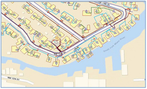
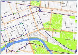
The sheer volume of data generated by planning, designing, building, and altering communications infrastructure, coupled with the pressure to operate efficiently, makes the job of data upkeep impossible, without a certain level of automation. Standard fiber management systems with GIS, enable operators to reduce or eliminate the need for paper documents, easily update cadastral & network information, and produce maps at a variety of scales to show any part of the infrastructure.
GIS enabled telecom asset management applications, help the service providers in many ways:
- Planning and engineering process supported by digital mapping
- Network asset modeling including inside and outside (ISP and OSP)
- Customization of GIS application to speed up and simplify the network design process
- Creating physical and logical connectivity
- Efficient fault management
- Quick asset maintenance and management
- Exact network routing information
GIS has certainly played a transformational role for the communications industry by helping the providers to expand their services in the remotest of areas. In the current cut-throat competition, it is imperative that the Telecom companies adopt GIS tools, not only to excel, but also to be sustainable in the long run.