
For over a century, gas pipeline organizations have been dedicated to enhancing their construction documentation methods. Traditionally, they utilized a process known as the “construction packet,” which was crucial for maintaining accurate as-built data essential for their ongoing Operations Maintenance activities and future planning endeavors. They needed precise information about the location of their infrastructure and the condition of their assets on the ground.
Recognizing the limitations of this older method, modern gas utilities have embraced recent technological advancements. These innovations, which include high-precision GPS antennas, mobile computing devices, and advanced mobile data collection applications, have brought about a remarkable era of efficiency, cost savings, and streamlined business operations. The shift from paper-based documentation to digital field as-built using GIS tools such as Esri ArcGIS is revolutionizing the industry, bringing about positive changes in utility asset management practices.

Many owners already use GIS as a record system for their assets – and more will be heading in this direction. But right now, they generally have to pass along the PDF, CSV, or CAD files of as-built information they receive at the close of a project to a back-office GIS to create that system of record.
Digital as-builts are living records of an asset’s as-built condition and are critical for the utilities. They take shape over the course of a construction project through real-time collection and sharing of as-built data. They can be updated to document changes in the asset management phase so they always reflect the asset as it exists.
A Brief Evolution of As-Built Documentation:
Traditionally, gas pipeline organizations used paper documentation for construction purposes. With the advent of digital technology, the industry saw three distinct generations of solutions:
- First-generation solutions focused on digitizing construction drawings.
- The second generation incorporated high-accuracy GPS units and barcode scanners to document newly installed assets while leaving other construction packet elements in paper format.
- The third generation, represented by the Digital Field As-Builting, introduces configurable maps, forms, and business rules to capture all construction documentation digitally.
Digital as-builts result from a continuous process of gathering and sharing information in real-time throughout construction – rather than a task relegated to the end of a project like their paper counterparts.
Challenges with Traditional As-Built Documentation:
Historically, the process of documenting gas pipe construction involved two distinct steps: design and as-built documentation. Designers created infrastructure sketches and construction drawings and handed them to field crews or contractors for construction. After construction, field staff documented the new infrastructure, and these edits were sent to the GIS team for updating the GIS database. This process incurred redundancy and additional costs due to duplicated efforts in both CAD and GIS systems.

Why is maintaining Digital As-Builts crucial?
Maintaining digital as-builts offers a multitude of indispensable advantages that prove invaluable not only during construction but also throughout the lifecycle of an asset. These benefits stem from several critical attributes inherent to digital as-built documentation.
- Firstly, the flexibility of cloud-based or on-premise storage ensures secure data sharing, granting all stakeholders easy access and retrieval capabilities. This feature enhances collaboration and data management, fostering efficient project oversight.
- Digital as-builts excel in providing real-time information. They furnish insights into ongoing work, enabling stakeholders to promptly access the latest project data, especially when uploaded to the cloud. This real-time access aids decision-making, project tracking, and swift response to developments.
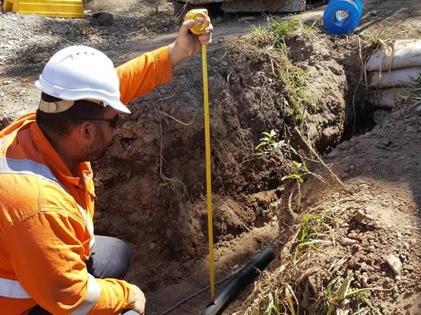
- The mobility aspect of digital as-builts is essential, as they capture data at the construction site, where the action occurs. Using mobile devices facilitates field data collection, ensuring that accurate and up-to-date information is incorporated into the documentation.
- Furthermore, digital as-builts stand out for their multi-dimensional nature, which includes various data types such as digital forms, photos, videos, GPS coordinates, geographic information systems (GIS), drone imagery, and as-built surveys. These diverse data elements collectively create a comprehensive, context-rich record of the asset, accurately representing its real-world existence.
- Finally, digital as-builts are inherently location-based, a crucial attribute in asset documentation. They record an asset’s location, often incorporating GPS coordinates for precise positioning. For assets lacking this metadata, location information and GIS mapping tools offer literal visibility of the asset and its associated documentation. This location-centric approach is instrumental in asset management and maintenance and ensures that the asset’s physical whereabouts are readily accessible and well-documented.
Benefits of digital as-builts
Digital as-built drawings are pivotal in utility construction, providing real-time visibility and streamlining project management. This digital transition allows immediate access to ongoing fieldwork on a single platform, empowering project managers to make informed decisions. It creates a digital thread connecting construction phases, enabling efficient planning while minimizing errors and standardizing data transfer. The resulting cost and time savings come from reduced manual data entry and streamlined information flow, enhancing overall project efficiency.
Furthermore, the real-time accuracy of digital as-builts helps identify issues promptly, minimizing the need for costly project revisions. In operations and maintenance, these drawings facilitate precise material traceability and efficient asset location within the utility sector, contributing to seamless infrastructure management.

The Secret Sauce – Configuration and Automation:
The successful deployment of a Digital Field As-Builting solution hinges on expertise in configuring GPS systems, mobile devices, and software to work seamlessly together. Effective configuration and automation are key to unlocking the full potential of this technology.
How can RMSI Help?
RMSI’s Digital Design and As-Built solution is a specialized GIS application designed for the gas utility sector, revolutionizing infrastructure design and documentation processes. It significantly reduces turnaround time and ensures consistent standards across departments. The Digital Design aspect offers a flexible ESRI-based drafting tool, simplifying network design, automating tasks like Bill of Material (BoM) generation, and expediting construction drawing creation. In contrast, the As-Built component empowers field staff with a versatile mobile app for collecting real-time data during construction, even in disconnected environments. This innovative solution eliminates the need for multiple technologies, avoids redundant work, and streamlines data transition from the field to GIS, enhancing efficiency and accuracy in gas utility operations.
As more gas organizations embrace Digital Field As-Builting with ArcGIS, the industry is on the cusp of a revolution in efficiency, cost-effectiveness, and data quality. Transitioning from paper-based documentation to digital workflows is pivotal for maintaining safe and reliable gas pipe networks. By harnessing the power of modern technology and embracing innovative solutions like ArcGIS Field Maps, gas utilities are positioning themselves for a more efficient and sustainable future, setting the stage for a paradigm shift in utility asset management.