Next Gen Mapping Solutions
RMSI (www.rmsi.com) is one of the world’s leading providers of navigation map development, maintenance, and enhancement services. We have over two decades of experience and have worked with most of the large global navigation map data providers.
We have an in-house team of over 3,800 mapping specialists, and have a demonstrable experience of working on large map data projects that required significant ramp up and training within a short turnaround time. RMSI is currently implementing one of the largest ongoing green-field map data initiative.
We invite you to visit our booth # 310 to demonstrate how we’ve helped our clients in their mapping journey.
TALK TO US. TAKE A DEMO.
Booth #310
GIVE US THE OPPORTUNITY TO UNDERSTAND YOUR NEEDS AND OFFER YOU INNOVATIVE SOLUTIONS.
Write to amit.rishi@rmsi.com


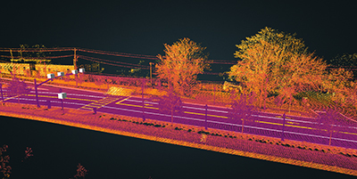 HD Map Creation & Maintenance
RMSI offers end to end HD map data development, from specifications to final product. RMSI has developed a proprietary framework catering to each stage of the HD map data development process – from user specification, vehicle data integration, attribute conflation for semantic 3D map creation to map validation. Our mapping framhome_map_03ework is based on Open Lane Model (OLM) and ADASIS (Advanced Driver Assistance Systems) standards.
Another value add to our HD maps are ‘AI assisted’ updates that enhance the efficiency of these maps. These updates are generated from collateral data that is obtained using various sensors and cameras.
AI Assisted Updates include:
Roadworks – Construction zones, Lane closures, Crowd, Heavy Machinery
Road Signage – Speed limits, Traffic lights, Hazards, Rumbles, Pedestrian crossings
Traffic Updates – Accidents, Delays, Road pricing, Road closures, Slippery road, Traffic diversions
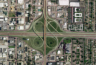 Map Data Development & Maintenance
RMSI is a leading global provider of navigation map data development, maintenance and enhancement services. We offer customized solutions for new map creation to our clients with value added services, such as modifying a geo-database for a specific country to enable provision of wall, fold, or flip maps, or regional and country map products.
RMSI helps clients develop, update, and maintain high quality map data products, points of interest (POI) databases, 3D landmarks and models that support in-car navigation, web and mobile applications, emergency management, and location-based services.
We have a ready to deploy, workflow driven proprietary navigation map prodiction toolkit – RMSI MapPro. RMSI MapPro has a suite of integrated tools for each stage of the the map data development life-cycle from input preparation, network data capture, attribution, video data capture, to POI integration. RMSI Map Pro has been successfuly deployed on multiple large map production engagements.
Key solutions include:
Map Data Development – Creating map databases involving creation of RAW GDB, Maplex and Structure GDB
Cartographic Refinement – Geometry cleanup, styling, text tidy, annotation and placement
Layout Design and Indexing – Custom layout creation and preparation of map indexes
Other services include: LiDAR data processing, satellite/aerial images sourcing and auto extraction, AI/ML based annotation & labelling, survey data acquisition, and map platform development.
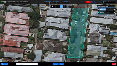 Data Annotation & Labeling
RMSI has developed an end-to-end platform for annotating and labeling large scale data. We help our customers to accelerate and scale their training data requirements. RMSI’s in-house annotator workforce is extremely experienced at performing high quality labeling tasks while delivering accurate annotated data using satellite imagery, aerial imagery, pictures & videos.
Our experts work closely with clients to understand their project needs and configure bespoke annotation workflows. These workflows transparently provide progress, quality and performance of annotations to achieve customer’s requirements at scale and on budget.
SOLUTION
Our solution uses multiple tools mentioned below to annotate and label data based on the input specifications. The geospatial label annotation can be exported in multiple format like geojson, shape file and bounding box labels can be exported in json and xml format.
2D Bounding Boxes
• Creating Bounding Boxes for Object Detection in images & videos
Polygons
• Drawing Polygons by identifying exact shape of the object in aerial and satellite imagery
Polylines
• Used for drawing lane and road line labels in aerial and satellite imagery
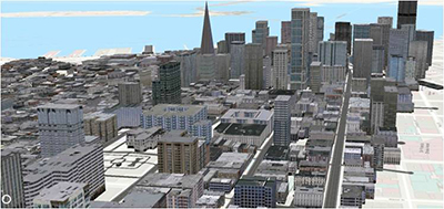 3D Landmarks & City Models
3D CREATION
RMSI has expertise in creating geographically accurate 3D models using photogrammetric technologies and in-house developed customized tools. Our experts create 3D Maps from high-resolution most up-to-date stereo pair’s satellite imageries with varied accuracy details.
Complementing the 3D image view is the accurate overlay of data layers on the stereo model. Superimposition techniques are used to facilitate the manual compilation of land base layers and vector data with desired possible accuracy.
Application Areas include Wireless Telecom, Urban Planning, Insurance, Disaster management, Defense and Security, Real state and Navigation etc.
3D CITY MODELS
The 3D city model is created using best available software applications that support the use and visualization of very large DEM (Digital elevation Model) and aerial images. Building models are created from building footprints in conjunction with height information using photogrammetric technologies.
Besides this, multiple layers of vector and raster data are added as terrain textures and labels or (3D)-symbols are added manually or based on point information. Users can interactively navigate through the 3D city model and attribute information attached to buildings or vector data can be queried.
Success Stories
- Implementing the largest greenfield navigation map data product in the world
- Enhancement & enrichment of global map data using aerial imagery, video data & field survey reports
- Geometry creation & attribute updates using high resolution aerial imagery
- Maintaining the currency & accuracy of OS mastermap for entire Great Britain
- House level geocoding for 36 Indian cities for building last mile connectivity
- Update and maintenance of navigation map data for Italy, North America and ANZ regions