
Volume - IV, 2016
<< backIn Focus
Building Climate and Disaster Resilience in Timor-Leste through Hazard, Vulnerability and Risk Assessment (HVRA)
Timor-Leste is a Southeast Asian nation, surrounded by coral reefs. It has mostly narrow coastal plains and a rocky northern coast. The country’s location and its mountainous topography make it highly susceptible to seismic activity and hydro-meteorological hazards.Historically, the nation has been vulnerable to a range of natural hazards including floods, strong winds, landslides, earthquakes and tsunamis. These hazards have caused significant damages in the past and it is essential to evaluate them, to reduce their impact and understand associated risks.
Recently, RMSI undertook a study in Timor-Leste with the objective of building climate and disaster resilience in the country by analyzing the various risks associated with these natural hazards, and using that information for effective disaster risk reduction. The study was supported by the ACP-EU Natural Disaster Risk Reduction Programme, an initiative of the African, Caribbean and Pacific group, funded by the European Union and managed by the Global Facility for Disaster Reduction and Recovery (GFDRR).
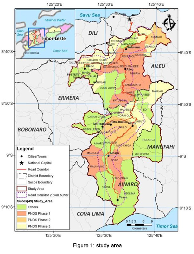
The primary objective of the study was to assess and analyze the risks from flooding, landslides and strong winds at Suco (village) level in the districts. Forty nine sucos of four districts (Ainaro, Aileu, Ermera, and Manufahi), which intersect Dili-Ainaro and linked road corridors, were selected for the Hazard, Vulnerability, and Risk Assessment (HVRA) modeling. Socio-economic vulnerability of communities was another component to be analyzed based on relevant indicators (poverty, access to markets, health and education indicators). Additionally, exposure data was developed to identify potential losses and included settlements, sites of cultural heritage, infrastructure and crops.
The secondary goal of the study was to build the technical capacity of the National Disaster Management Directorate (NDMD) and relevant stakeholders in collecting, managing and using risk information, and in conducting risk assessment. To achieve all the above objectives, RMSI’s team worked closely with the NDMD and the district Administrations of Aileu, Ermera, Manufahi, and Ainaro.
RMSI put together a multi-disciplinary team comprising hydrologists, meteorologists, seismologists, geologists and remote sensing professionals. The team undertook probabilistic hazard assessment based on historical data, and scientific models. An exposure database was developed constituting all the susceptible assets including buildings, demography, transport, agriculture, and critical facilities like educational institutes and health facilities.
In addition, our experts developed a Social Vulnerability Index to identify people, households, groups, and communities with different levels of susceptibility to disasters and drive their ability to respond to the various types of hazards that Sucos face. The next step was risk modeling which generated risk matrices by hazard - Probable Maximum Loss (PML), Loss Exceedance Curve (LEC), and Average Annualized Loss (AAL). Extensive training sessions including field exercises were conducted for the key stakeholders within NDMD and other ministries.
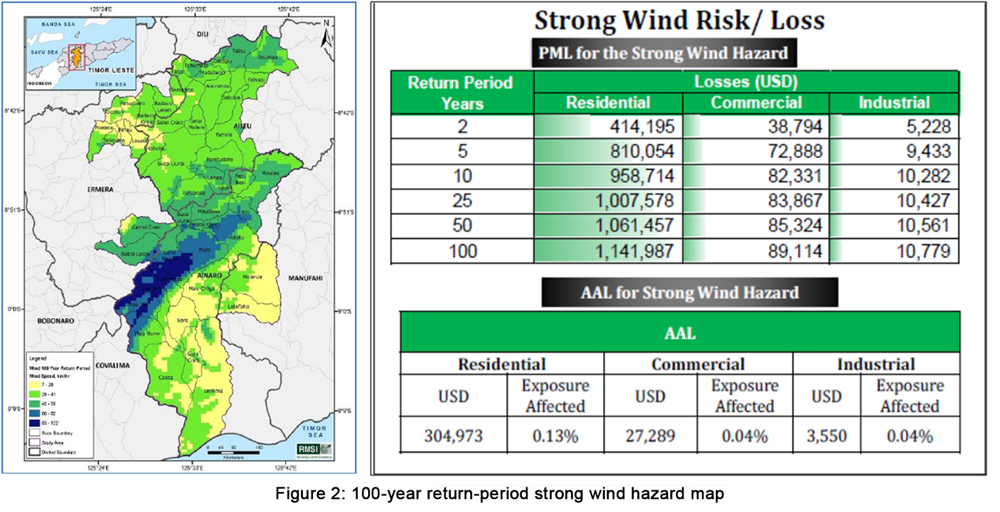
As per the study outputs “strong wind” was identified as one of the most damaging hazards in the study area. Strong wind events normally occur in the country during March-April and September-October. The country experienced about 19 strong wind events, between 2002 and 2011, affecting 2015 individuals and damaging 1,863 houses.
Simulation results of strong wind hazard for 100-year return period (RP) show that Ainaro district is likely to have 15 sq. km of area affected by high wind speeds of 100 km/h’
Considering 25, 50, and 100-year return periods, the analysis indicated that the north-western part of Ainaro district was prone to strong winds (>75 km/hr).
The higher wind speeds could be attributed to local topography, and the presence of mountain ranges in these districts. The wind speed increases over the mountainous region due to positive pressure gradient, i.e., the pressure decreases with increase in altitude.
The study results clearly indicated that the high-resolution WRF model with spatial grids of 500 m x 500 m could efficiently resolve the impacts of local topography and orography on wind fields.
Similarly, study and analyses for other hazards including floods and landslides were also conducted. Flood hazard analysis was conducted to understand the frequencies, extent and depth of flooding. It was observed that Letefoho, Riheu, Poetete, Leolima, and Ainaro were the most flood affected sucos while Acumau and Fahisoi were the least affected ones.
For landslide susceptibility mapping, various factors were considered viz. Slope angle, Geology/ Lithology, Soil, and Land use/Land cover, Rainfall, and Seismicity. It was found that impact-wise Letefoho Suco of Manufahi district, and Ainaro, Aitutu, Mulo, Nuno-Mogue, Leolima Sucos of Ainaro district were most susceptible to landslide hazard.
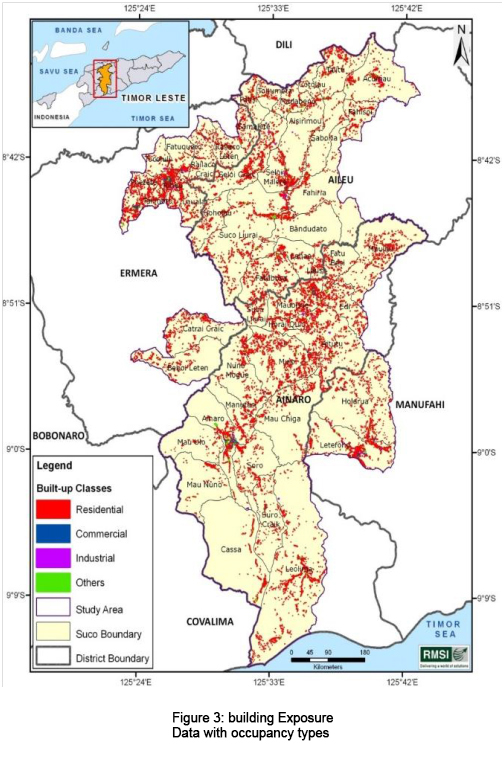
GIS played a crucial role in this study as it helped in spatial analysis, visualizing the hazard and exposure data (Figure 3), and generating final outputs of the analyses.
Finally, the outputs were integrated into a hazard and risk data-sharing platform with an easy to use, customized user interface (UI).
Conclusion
The outputs of this assignment are supporting the development objectives of World Bank’s Timor-Leste Road Climate Resilience Project (RCRP, P125032) which aims to deliver sustainable climate resilient road infrastructure on the Dili-Ainaro corridor through its rehabilitation. This initiative is expected to significantly improve the rural population’s accessibility to better opportunities of livelihoods, making them more resilient to disaster and climate risks.At a larger level, the study will help improve the understanding of hazard risks, and minimize the losses to infrastructure assets and livelihoods of communities through risk-informed planning and community-based action. The extensive capacity building of the national stakeholders can be further utilized by replicating the initiative in other parts of the country.
Click Here to view the Synthesis Report of this study.
Recent Wins
Developing Flood Forecast and Inundation Mapping Model for Rapti River Basin in Uttar Pradesh (UP), India
Climate Adaptation in Vennar Sub basin in Cauvery Delta Project (CAVSCDP), India
Current Development Projects
Climate-Resilient Coastal Protection and Management , India
NAT CAT Risk Analysis in Morocco
Events
9th India Rendezvous Jan 20-22, 2016, Mumbai, India
Expert in Focus
Dr. Indu Jain
Oceanographer