
Volume - V, 2017
<< backIn Focus
Developing a Cyclone Hazard and Risk Atlas for India
Hazard, Risk and Vulnerability Assessment (HRVA) For 13 Coastal States & UT’s in India
Out of the 7,500 km total coastline of India, approx. 5700 is exposed to severe cyclones, and an estimated 40% of the total population lives within 100 km of the coast. On an average, between one third to one half of the tropical cyclones affecting this region hit the Indian coastline, which by nature is susceptible to storm surge due to shallow coastal bathymetry and tidal characteristics. Other factors such as low-lying terrain, high population density and limited community awareness further make the population in these coastal States/Union Territories (UTs) extremely vulnerable.
The Orissa super-cyclone of 1999 killed over 10,000 people and millions suffered severe physical and financial losses. In subsequent cyclones, Phailin in 2013 and Hudhud in 2014, the death toll reduced significantly because of timely evacuation of a large number of populations in both the cyclone events, however, there were significant physical and financial losses. Hence , the Government of India conducted risk assessment and vulnerability study to mitigate the adverse effects of future disasters.
RMSI undertook a Hazard, Risk and Vulnerability Assessment Study for 13 States and UT’s in India which was a part of the National Cyclone Risk Mitigation Project (NCRMP) project. Conducted by - Ministry of Home Affairs (MHA), Government of India (GOI) and implemented through NDMA, with the financial support from the World Bank.
The aim of NCRMP is to create suitable physical infrastructure to mitigate/reduce the adverse effects of cyclones.
This innovative project involved setting up a web-based Cyclone Risk Atlas called the Composite Risk Atlas (CRA) that would provide a risk management framework for decision makers in the 13 States/UTs and the Central Government to take mitigation steps to protect the people and assets of the country.
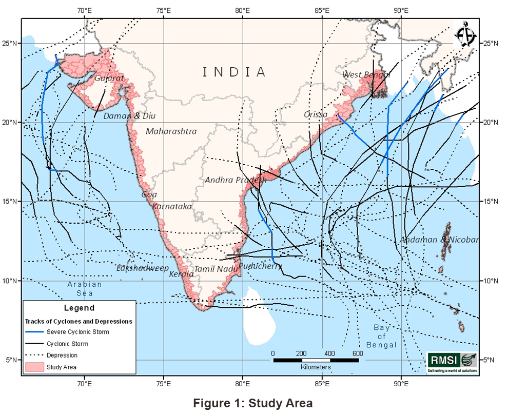
The study area included the coastal stretches that lie up to 10 m above Mean Sea Level (MSL) in the districts of the 13 coastal States/UTs, which could be vulnerable to cyclone winds, surge and cyclonic rainfall induced flooding. Total number of talukas/mandals selected for the study having geographical extent up to the 10 m MSL limit, were 617 and these selected talukas are shown in Figure 1. The total geographical area covered by these talukas/ mandals considered was around 2,55,000 sq km.
These 13 States/UTs were further classified into two categories, based upon the frequency of cyclone occurrence, size of population and the existing institutional mechanisms for disaster management. The category-I included higher vulnerability coastal States/UTs, i.e., Andhra Pradesh, Gujarat, Odisha, Tamil Nadu, and West Bengal, whereas category-II included lower vulnerability coastal States/UTs, i.e., Maharashtra, Goa, Karnataka, Kerala, Daman & Diu, Puducherry, Lakshadweep, and Andaman & Nicobar Islands.
The overall objective of the study was to provide a robust scientific and practical basis for assessing hazard, vulnerability and risks involved with cyclone, storm surge, and rainfall induced flooding associated with cyclones for the 13 coastal States/UTs of India.
The primary objective of this study was to develop standardized spatial databases, maps and a decision support framework for assessing the cyclone and related hydro-meteorological hazards, exposure, and vulnerability.
Additionally, the government wanted to identify critical ‘hotspots’ of high vulnerability coastal areas for communities at-risk and detailed planning/mitigation measures and emergency response decision support mechanisms.
Another objective of this study was to develop a platform for dynamic risk assessment modeling functionalities and a web-based GIS Risk Atlas to help decision makers in the States/UTs and Central Government to make informed decisions regarding mitigation measures to protect the people and assets in these coastal regions.Solution
RMSI put together a multi-disciplinary team of professionals on this project. The team undertook development of probabilistic hazard assessment models based on historical data, and other scientific data. An exposure database was developed constituting all the susceptible assets including buildings (residential, commercial, and industrial); demography; infrastructures such as transport; and critical facilities like fire stations, police stations, health facilities, educational Centers, Cyclone shelters and power plants.
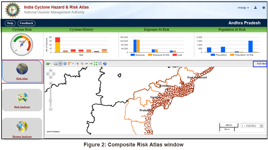
The Web-CRA provides users with the functionality to view various layers such as administrative boundaries, base layers, transportation layer etc. These layers can be used in conjunction with one another (Figure 2).
This module has a functionality that enables users to update the aggregated and site-specific exposure and vulnerability details. It also enables users to carry out risk analysis and loss estimation for three hazards including cyclone, flood and storm surge, individually as well as composite.
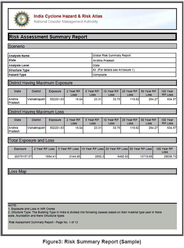
The Web-CRA comes with several ready reports such as summary and detailed exposure reports, risk analysis summary reports, and detailed hot-spot report. These are canned reports that allow the user to view exposure and losses at different admin levels for the State/UT for which they hold the access rights. The risk summary report can be generated for cyclone, flood, surge, and composite losses for all the three hazards (Figure 3) at different admin levels.
The hotspot analyzer (Figure 4.) module enables users to update the aggregated and site specific exposure details for hotspot locations only. The module enables users to carry out hotspot buffer analysis and risk analysis for loss estimation due to three hazards and a hotspot analysis report gets generated. The layers include hotspot locations, building, essential facilities, transportation, utilities, and administrative boundaries.
Conclusion
At a larger level, the final product- a Web-CRA will help the decision makers in various States/UTs and Central Government in informed planning for cyclone risk mitigation. This will also support in providing a framework for specific decision-support needs (evacuation planning, and shelter requirement, etc) at village level.
Recent Wins
Climate Change Scenario Modeling and Risk Assessment, Lesotho
Multi-Hazard Risk and Vulnerability Assessment (HRVA) for the Cities - Shillong (Meghalaya), and Cuttack (Odisha)
Current Development Projects
Development of an Electronic Database & Information Management System, Uganda
Development and Launch of the Philippine Statistics Authority (PSA) Open Data Portal

Events
14th Insurance & Reinsurance Carthage Meeting, 26 - 28 March 2017, Tunis
FICCI 10th India Climate Policy and Policy Business Conclave, 23 - 24 March 2017, New Delhi
Expert in Focus
Pratul Srivastava
Hydrologist