In Focus
Building Climate Resilient Livelihood in Gambia Using Geospatial Technology
Client: Ministry of Environment, Climate Change, and Natural Resources, Republic of the Gambia with support from African Development Bank (AfDB)
Start Date: August 2019 | End Date: April 2020
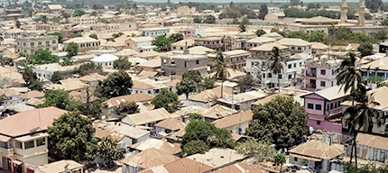
The vulnerability of climate change is complex and diverse in West Africa. One such country experiencing climate extremes (such as drought & flood) is Gambia, a small country located along the Gambian river. The Atlantic Ocean surrounds Gambia to the west and Senegal along all other borders. Gambia is one of the densely populated countries in Africa. The city is built on a small peninsula between mangrove-lined estuaries and the Gambia River, which rises out of the Fouta Djallon Highlands of Guinea. With its natural port, Banjul is an important trading post between West Africa and the world.
Recent Wins
Study on Issue of Flood and Siltation in River Ganga and its Tributaries due to Farakka Barrage, Bihar
Client: Central Water Commission
In India, flood is a major concern due to loss of life and infrastructure. The primary cause of flooding is excess of flood in river than its carrying capacity. Generally, in the hydrologic process of draining the rainfall from the catchment, sediments generated from eroded uplands & channel boundaries also get tagged in the natural channels. These sediments carried along get settled when the driving velocity of flow is unable to carry their weight, resulting in siltation and sedimentation.
Flood Plain Zoning in Meghalaya
Client: Water Resources Department, Government of Meghalaya
Meghalaya is the wettest region of India recording an average of 3,000 mm of rainfall in a year. While the northern part of this plateau merges with the plains of Assam, the southern portion drops down abruptly to meet the plains of Bangladesh.
Current Development Projects
Study on Risk Management & Resilient Infrastructure Development of Inland Water Transport (IWT), Assam
Client: The World Bank
Assam is vulnerable to climate change due to its location in the Eastern Himalayan periphery. The State is characterized by high rainfall with annual floods whose severity has risen due to adverse climatic conditions. With very few bridges and an underdeveloped road network, the rivers act as lifelines for the physical movement of people and goods across the state. Accessible and affordable public inland water transport (IWT) is thus extremely vital for the lives and livelihoods of the predominantly rural communities in Assam.
Hazard Mitigation & Resilience Plan, U.S. Virgin Islands
Client: University of Virgin Islands, U.S.
Rain induced flooding is one of the most common and disrupting events in the U.S. Virgin Islands. This impacts the critical infrastructure and interrupts daily life and economic activities.
Events
RMSI acknowledged as 'Partner of the Year - ISV Solution' by Esri India
RMSI Webinar on Flood Forecasting & Early Warning Systems, June 2021
International Conference on Disaster Risk Management, July 2021
Expert in Focus
Dr. Pratap Singh
Water Resources Expert & VP - Sustainability, RMSI