<< backIn Focus
Major Coastal Cities of India are under threat due to the rise in sea level by 2050
As per the IPCC report, India is highly vulnerable to sea-level rise and will see a shift in the entire coastline. Mumbai ranked second to incur significant economic losses due to submergence due to sea-level rise. As per our analysis, around 14.4 km of the road network and approximately 571 key buildings are potentially at risk from inundation due to rising sea levels. Areas around Mithi river, parts of Colaba including Sagar Mata Temple, Priyadarshani Park, the area behind Shree Mahalakshmi Temple, the area behind Breach Candy Hospital, Haji Ali Durgah, Coastal areas around Worli, including all the clusters next to Mahim Fort, will be submerged. Juhu airport is at risk as water may cross the road after high tides and enter the airport. The area around Jawahar Lal Nehru Port Trust will also be submerged. The low-lying regions will see a direct and immediate impact compared to the elevated regions. It will potentially damage the fish breeding in the coastal areas impacting local fishing livelihoods.
In light of the new sea-level rise forecasts for 2050, the Government of India should initiate a project towards creating India's new coastline, inundation mapping, and disaster preparedness along the entire Indian coastline. Once the new coastline is prepared, all the areas located to the left of the new coastline (towards the ocean), whether residential, industrial, or infrastructure, have to be relocated. Additionally, the increase in the water level of all rivers and creeks should be modeled, and areas permanently underwater should be marked. Furthermore, inundation mapping for Mumbai and other cities at risk due to rising sea levels becomes a very high priority with this new reality.
"All this should be incorporated into a Decision Support System to guide the planners to relocate the assets to the left of the new coastline, plan new development in light of the recent flood risk maps, decide on plinth levels, basements, etc. This DSS will also support forecasting the risk in extreme rainfall and cyclone events," says Pushpendra Johari, SVP, Sustainability, RMSI.
A study conducted by RMSI, a Noida-based IT consulting firm (based on IPCC reports) for key coastal cities of India, reveals that due to the rising sea levels by 2050, a significant number of population, property, and infrastructure will be underwater. Some critical properties and road networks are at risk of being submerged by 2050, including Breach Candy Hospital, Haji Ali Durgah, Jawahar Lal Nehru Port Trust, Western Express Highway on Bandra-Worli Sea-link, and Queen's Necklace on Marine Drive in Mumbai and Napier's Bridge Road in Chennai.
The Intergovernmental Panel on Climate Change (IPCC) Assessment Report indicates that India's sea level will rise significantly by 2050. Also, the findings of "Assessment of climate change over the Indian region: A report of the Ministry of Earth Sciences (MoES), Government of India," indicated a significant increase in the rate of sea-level rise. Sea-level rise in the North Indian Ocean (NIO) occurred at a rate of 1.06–1.75 mm per year from 1874 to 2004 and has accelerated to almost double to 3.3 mm per year in the last two and a half decades (1993–2017). The RCP4.5 scenario projects that the steric sea level of the NIO will rise by approximately 300 mm relative to the average values from 1986 to 2005. The corresponding projection for the global mean rise is approximately 180 mm.
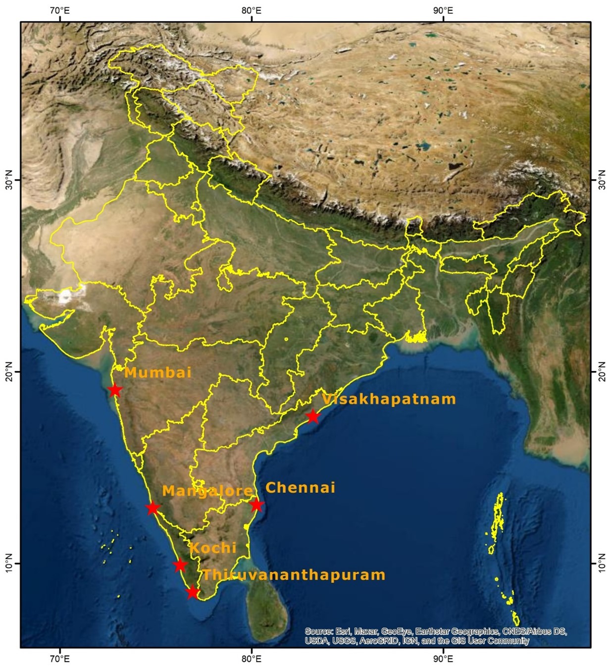
RMSI did a deep dive into the IPCC findings and various publications based on the IPCC report by coupling its numerical models with the latest climate change data to find out possible repercussions for India. Six major coastal cities of India viz. Mumbai, Chennai, Kochi, Vizag, Mangalore, and Thiruvananthapuram were considered for this analysis. RMSI's experts created a high-resolution Digital Terrain Model (topography) at sub-meter accuracy for the coastline of the identified cities. Further, RMSI used its coastal flood modeling capabilities to map the cities' inundation (submergence) levels based on various sea-level rise forecast studies.
RMSI tried to identify and quantify the impact on the above six key cities under high threat. Based on the inundation RMSI conducted a detailed analysis to identify the number of buildings and key infrastructure that could be potentially submerged in each of these cities. (Refer: Figure 1: Location map of six major coastal cities of India)
Figure 1: Location map of six major coastal cities of India
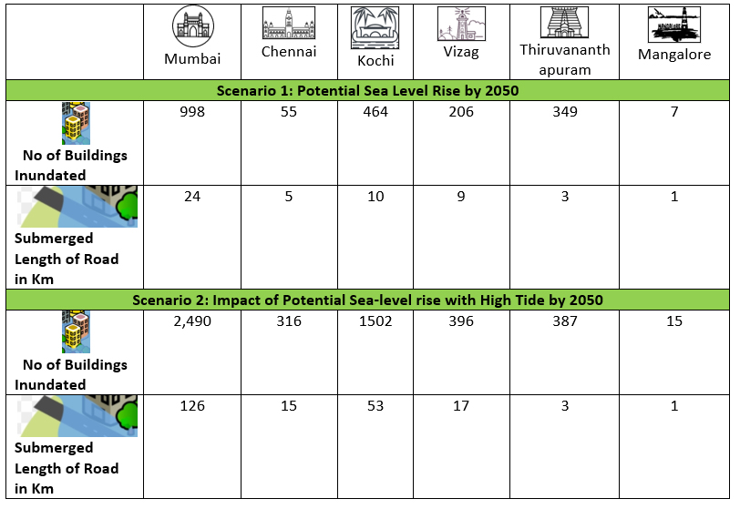
Along with the sea level rise scenario, RMSI also performed a what-if scenario to see the potential inundation level combined with a sea-level rise by 2050 with high tide. The two scenarios together will help to understand which areas are permanently submerged against the ones that would be inundated at the time of high tides.
Agriculture in Malawi is dominated by maize and tobacco followed by other food and cash crops such as cassava, sweet potatoes, sorghum, tea, sugarcane, cotton, and coffee. More than 80 percent of the total arable land is cultivated by smallholder farmers. Most of these farmers are dependent majorly on the production of maize grown on 70 percent of the arable land.
This led to increased imports of legume production such as soybean, pigeonpea, and groundnut causing a massive burden on the government’s exchequer. Hence, the government decided to diversify the production by distributing agri-inputs to grow the legumes.
KEY FINDINGS
The findings of this analysis provide a worrying picture, as summarized below:
Is action being taken to prepare for climate change impacts?
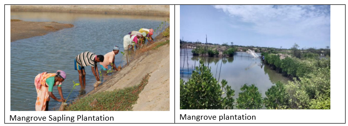
The Government of India has prepared State Action Plan on Climate Change (SAPCC) for thirty-three states in line with the 2008 National Action Plan on climate change (NAPCC), considering the State's specific issues relating to climate change. SAPCCs have studied the present and future climate change scenarios and their likely impacts on the climate. As part of the SAPCCs, multiple projects have been conducted, such as Integrated Mangrove Fish Farming, Shoreline Management Plans for five coastal stretches, namely, Gulf of Kutch (Gujarat), Gopalpur to Chilika (Odisha), Paradip to Dhamra (Odisha), Digha to Sankarpur (West Bengal) and Sagar Island (West Bengal), Shoreline protection projects in Tamil Nadu and Pondicherry for beach restoration. In addition, the Government has also initiated projects across the States of Andhra Pradesh, Maharashtra, and Odisha to enhance the climate resilience of India's coastal communities in these States.
Source: M.S. Swaminathan Research Foundation (MSSRF)
Key challenges to be addressed
Our understanding of how the SAPCCs is being implemented is that most climate change-related issues are currently being addressed in silos. There is a strong need to integrate them at the national level because climate change aggravates hydrometeorological hazards. Secondly, the scope is limited to the state authorities without a clear delegation of activities and strategies at the decentralized level. Integrating the district authorities and localizing the State Action Plan will better implement the projects. Thirdly, a proper methodology needs to be built for up-scaling the pilot projects.Based on our study of these cities with limited resources, we believe a detailed analysis of India's entire coastline is essential. We understand that the required datasets are already available as part of the coastal zonation project initiated by the Government of India (GoI). With increasing climate-related impact, it is high time for the Government to engage and exchange high-quality topography data with the key stakeholders, professionals, and local communities to address these issues.
Key focus areas
- Identify sea level rise in 2050 and 2100 (will be different at different locations)
- Use of a High-resolution inundation model to identify the areas at risk with higher accuracy
- Create a list of high-risk areas by sector so that respective authorities can work on the mitigation options (e.g., There can be a potential impact on a lot of fisheries along the coast of India)
This exclusive RMSI study has garnered significant media attention from leading national and global publications.
Click here to access media coverage
Recent Wins
Resource management and disaster resilience on Kopili river, Assam
Assessment and development of investment plans for strengthening hydrometeorological networks in Cambodia and Lao PDR
Current Development Projects
The Lesotho Highlands Water Project (LHWP) climate change vulnerability assessment and development of an adaptation and mitigation strategy
River-Basin Planning for Water Management for Konkan Bhasin
Events
Visit of Scientists and Technologists from IIPA, by the Department of Science & Technology to RMSI
9th Annual CAT RISK Management and Modeling summit 2022
International Conference on Climate and Weather-related Extremes (ICCWE 2022)
Expert in Focus
Dr. Murari Lal
Climate Change Practice Head, RMSI