In Focus
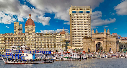
Major Coastal Cities of India are under threat due to the rise in sea level by 2050
As per the IPCC report, India is highly vulnerable to sea-level rise and will see a shift in the entire coastline. Mumbai ranked second to incur significant economic losses due to submergence due to sea-level rise. As per our analysis, around 14.4 km of the road network and approximately 571 key buildings are potentially at risk from inundation due to rising sea levels. Areas around Mithi river, parts of Colaba including Sagar Mata Temple, Priyadarshani Park, the area behind Shree Mahalakshmi Temple, the area behind Breach Candy Hospital, Haji Ali Durgah, Coastal areas around Worli, including all the clusters next to Mahim Fort, will be submerged. Juhu airport is at risk as water may cross the road after high tides and enter the airport. The area around Jawahar Lal Nehru Port Trust will also be submerged. The low-lying regions will see a direct and immediate impact compared to the elevated regions. It will potentially damage the fish breeding in the coastal areas impacting local fishing livelihoods.
In light of the new sea-level rise forecasts for 2050, the Government of India should initiate a project towards creating India's new coastline, inundation mapping, and disaster preparedness along the entire Indian coastline. Once the new coastline is prepared, all the areas located to the left of the new coastline (towards the ocean), whether residential, industrial, or infrastructure, have to be relocated. Additionally, the increase in the water level of all rivers and creeks should be modeled, and areas permanently underwater should be marked. Furthermore, inundation mapping for Mumbai and other cities at risk due to rising sea levels becomes a very high priority with this new reality.
"All this should be incorporated into a Decision Support System to guide the planners to relocate the assets to the left of the new coastline, plan new development in light of the recent flood risk maps, decide on plinth levels, basements, etc. This DSS will also support forecasting the risk in extreme rainfall and cyclone events," says Pushpendra Johari, SVP, Sustainability, RMSI.
Recent Wins
Resource management and disaster resilience on Kopili river, Assam
Client: Government of Assam
The Kopili River is the largest south-bank tributary of the Brahmaputra River. It originates in the Meghalaya State's Borail Hill range and drains an area of about 16,421 sq km. Given the topography of the Kopili River basin, rainfall during monsoon periods, conversion of wetlands for other purposes due to increasing population pressure, and increased backwash where the Kopili River meets the Brahmaputra River, the downstream areas of the Kopili are prone to flooding events.
Assessment and development of investment plans for strengthening hydrometeorological networks in Cambodia and Lao PDR
Client: The World Bank
The Southeast Asia (SeA) region is highly vulnerable to the impacts of natural hazards. Hydrometeorological hazards, such as strong winds, floods, or droughts, and subsidiary hazards, such as landslides, pose a direct threat to lives and impact livelihoods by damaging and destroying infrastructure, assets, and land. In addition, underlying processes, including climate change impacts, population growth, land use change, and urbanization patterns, are resulting in an increase in the number of people, infrastructure systems and services, livelihoods, and assets in Cambodia and Lao PDR at risk from hydrometeorological hazards.
Current Development Projects
The Lesotho Highlands Water Project (LHWP) climate change vulnerability assessment and development of an adaptation and mitigation strategy
Client: The Lesotho highlands development authority, Kingdom of Lesotho
Climate change is already a measurable reality. Along with other developing countries, the Kingdom of Lesotho (Lesotho) is extremely vulnerable and exposed to the impacts of climate change due to its socio-economic and environmental context. Climate change's effects are already reflected in reduced rainfall, which negatively affects catchment yields, surface and groundwater resources, springs, and rivers.
River-Basin Planning for Water Management for Konkan Bhasin
Client: Ministry of Water Resources, River Development & Ganga Rejuvenation, India
West Flowing River Basins is a set of 42 rivers originating in the Maharashtra state's western region(Sahyadri) and flowing along the western slope to meet the Arabian Sea. A large number of major, medium and minor water resource projects have been constructed in the West Flowing River basin of Maharashtra.
Events
Visit of Scientists and Technologists from IIPA, by the Department of Science & Technology to RMSI
9th Annual CAT RISK Management and Modeling summit 2022
International Conference on Climate and Weather-related Extremes (ICCWE 2022)
Expert in Focus
Dr. Murari Lal
Climate Change Practice Head, RMSI