This project – Assam Forest Biodiversity Conservation Society (APFBC) initiative was an initiative by the client – Assam Government – to use drone technology and supported payloads for various forest and wildlife conservation purposes.
The client aimed to enhance the conservation efforts in preserving the state’s rich natural heritage along with addressing the growing challenges of wildlife management.
The Challenge
To address its wildlife and forest management challenges, the department required a more efficient, accurate, and cost-effective approach to forest monitoring and protection. The existing reliance on manpower-intensive field operations limited coverage, increased response time, and constrained data accuracy. The client sought to reduce dependence on manual surveys, improve operational efficiency through rapid data acquisition, and enable high-precision monitoring of forests, including tracking the movement of iconic wildlife species and supporting remote surveillance for faster response to deforestation, encroachment, surveillance, and human–wildlife conflict situations.
The Solution
The Government of Assam pioneered the adoption of drone-based technologies to modernize forest and plantation management—marking a first-of-its-kind initiative by a State Government in India. RMSI, as System Integrator to APFBC, implemented a proof-of-concept across five priority use cases to identify optimal drone and sensor payload combinations for operational deployment.
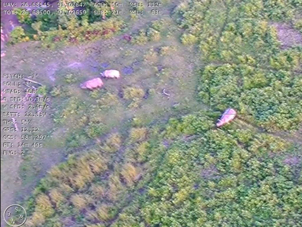
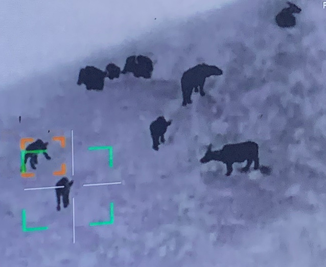
The solution deployed multirotor, VTOL, and tethered drones equipped with RTK/PPK-enabled RGB, multispectral, thermal, and LiDAR payloads for plantation monitoring, wildlife surveillance and conflict animal tracking (with target lock and auto-follow), encroachment detection, and forest resource assessment. Tethered drones were introduced to assess the capability for persistent aerial surveillance in high-risk zones, supporting anti-poaching, camp security, and conflict hotspot monitoring.
All drone-acquired data is processed through an enterprise geospatial platform and integrated with the Forest Management Information System (FMIS), enabling automated generation of orthomosaics, terrain models, and forest health layers to deliver automated analytics and AI/ML-based insights. The results are disseminated through centralized dashboards and mobile applications, enabling near real-time situational awareness, faster response, and evidence-based decision-making for forest protection, wildlife conservation, and disaster response. RMSI’s award-winning implementation was recognized at the Geosmart India Excellence Awards 2024 for its application, innovation and impact in forest and wildlife governance.
Tech Stack
UAV & Tethered Drones
ArcGIS Site Scan
Enterprise GIS Platform
AI/ML Feature Detection & Change Analytics
The Impact
The initiative undertaken by the Government of Assam represents a significant advancement in forest protection and conservation operations. It is expected to play a pivotal role in mitigating human–elephant conflict and strengthening wildlife rescue and response mechanisms, particularly through accurate and timely assessment of crop-raiding and conflict-related damage.
The project’s effectiveness is demonstrated through measurable outcomes from data analysis and field validation. Drone-based surveys have proven to be nearly five times more cost-effective than satellite-based methods while delivering 30–40% higher accuracy. Data processing and analytics turnaround time has been reduced from weeks/days to just hours, enabling near real-time decision-making. Additionally, drones provide ultra-high-resolution outputs—often better than 5 cm—far exceeding the typical 1–10 meter resolution of satellite imagery. When equipped with LiDAR payload, it further enables precise 3D digital twin and canopy structure mapping even under dense forest cover.