logo_RMSI
Global

Public Sector
Solutions and Tools

India Flood Risks

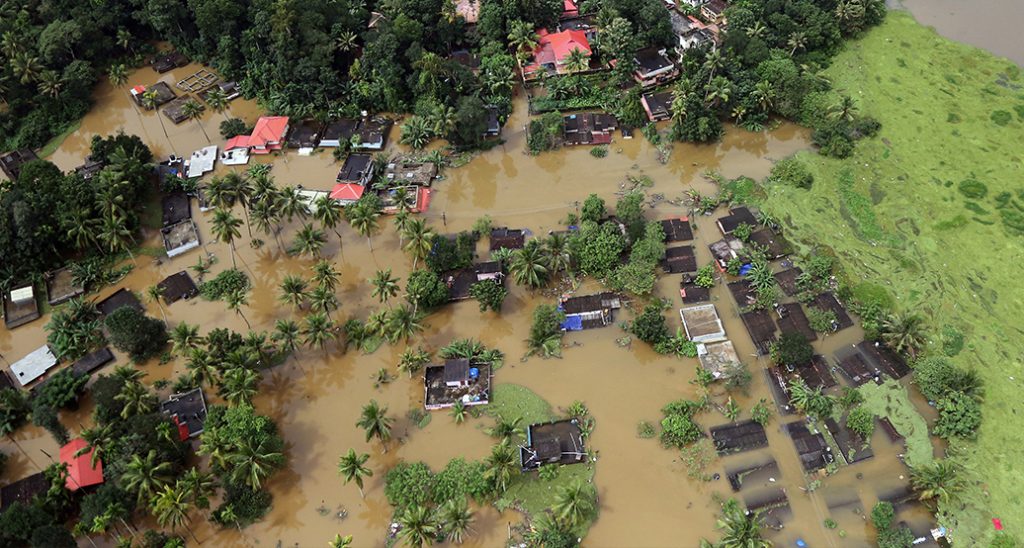
RMSI’s India Flood Risk solution provides detailed insights into riverine and pluvial flood hazards across the country. Using high-resolution geospatial data, hydrological modelling, and historical flood information, it supports floodplain mapping, exposure assessment, and impact analysis. The solution enables government agencies to strengthen flood mitigation planning, infrastructure resilience, and disaster preparedness at national and state levels.

Earthquake Risks

RMSI’s Earthquake Risk solution delivers seismic hazard and risk assessments to support disaster risk reduction and resilient infrastructure planning. By integrating hazard models, exposure data, and vulnerability analysis, it enables scenario-based impact assessment for buildings, lifelines, and communities. The solution supports evidence-based policymaking aligned with national seismic risk management frameworks.

India Cyclone Risks

RMSI’s India Cyclone Risk solution offers data-driven insights into cyclone hazards affecting coastal regions. It combines historical cyclone data, hazard modelling, and exposure assessment to evaluate potential impacts on infrastructure and populations. The solution supports preparedness planning, mitigation strategies, and response readiness for public-sector disaster management authorities.

Forest Management Information System (FMIS)

The Forest Management Information System (FMIS) enables government agencies to plan, monitor, and manage forest and wildlife sustainably through an integrated digital platform. It combines GeoAI, remote sensing, and field-based information to support forest inventory, land-use and change monitoring, biodiversity conservation, and resource planning. FMIS strengthens transparency, improves operational efficiency, and ensures evidence-based compliance with environmental regulations and conservation policies.

SirennX

SirennX is an AI-enabled emergency management and decision support platform delivering real-time situational awareness and multi-hazard impact forecasting. It integrates geospatial intelligence, early warnings, weather data, and field inputs to support coordinated disaster response. Deployable at state, district, city, and organizational levels, the platform enables authorities to assess impacts in advance, prioritize actions, and deploy resources effectively across response and recovery phases. Its scalable, API-ready architecture strengthens inter-agency coordination and emergency resilience.

SpatialVue

SpatialVue is a geospatial visualization and decision-support platform developed by RMSI to help organizations explore, analyze, and manage spatial data more effectively. The platform enables users to integrate geospatial and attribute data, visualize assets and networks on interactive maps, and support planning, monitoring, and operational workflows.

SAFIRE- Software Application Framework for Intelligent Risk Estimation

SAFIRE is an advanced decision support framework for multi-hazard risk assessment, combining a pre-built Risk Atlas with scenario-based analysis for risk-resilient planning. It enables deterministic and probabilistic risk evaluation through integrated modules for risk visualization, analysis, and hotspot identification. The platform supports disaster preparedness, response, and recovery by dynamically assessing impacts on assets and enabling ground-truthing. With “what-if” scenario modelling and reporting capabilities, SAFIRE helps authorities evaluate mitigation options and optimize investment decisions.

Let's Talk

Let’s Build Safer, Smarter, Resilient Communities Together. Tell us about your project and our experts will reach out.

En