
Today, one of the major challenges for utilities is understanding the legal rights on their transmission Right of Way (ROW) and accessing private properties to fulfill the maintenance cycles of the transmissions assets. In the course of this process, companies are ending up in conflicts with private property owners, and sometimes that leads to huge penalties due to incomplete information. Also retrieval of the corresponding documents such as deeds, court permissions, permits, purchase, etc. are further killing processing time.
Due to the legacy records available only in hard copies, retrieving the required information happens to be cumbersome and time-consuming. Some of the key challenges includes:
- Private landowner’s objections during asset maintenance
- Delay in retrieval of permission documents causes further delay in vegetation management
- Landowner queries are left unanswered
- Information is available but not spatially referenced (Legacy data is in hard copy format).
- No link between legacy data and current data
- A small mistake leads to huge penalties
To address these issues and fulfill the guidelines regarding vegetation management, it is more essential now for utility companies to transform the original corresponding documents like deeds/agreements, court permissions, permits, survey drawings, and purchase documents, etc. into digital format for easy retrieval.
Most easements are perpetual in duration. As such, when a property is sold or transferred to another, the easements remain in effect and are binding to the new owner.
For efficient ROW management, RMSI’s customised solutions helps utilities to transform original deeds, purchase reports, and survey drawings to a GIS database. This helps in fast retrieval of legal documents, clarifying landowner queries online within quick turnaround, vegetation management, and reduced survey time for planning & new construction, etc.
How does RMSI help?
A company needs to have expertise in the understanding of the Public Land Survey System (PLSS) and Contract Agreements (Deed Records) to undertake these requirements.
What is PLSS?
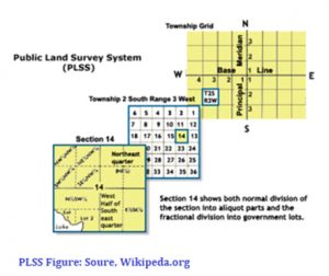
PLSS: The Public Land Survey System (PLSS) is the surveying method used historically over the largest fraction of the United States to survey and spatially identify land parcels before the designation of eventual ownership, particularly for rural, wild or undeveloped land. PLSS works on a grid-based Township Range and Section (TRS) details.
Township – Synonym for Survey Township, i.e., a square parcel of land of 36 square miles, or a measure of the distance north or south from a referenced baseline, in units of six miles.
Range: A measure of the distance east or west from a referenced principal meridian, in units of six miles.
Section: An approximately one-square-mile block of land. There are 36 sections in a survey township.
Contract Agreements (Deed Records): A contract between the property owner (grantor) and the party seeking the easement or right of way (grantee) on or across that property. This contains the strip information measured in meets and bounds and refers to the PLSS grid.
The right of way or easement can be for utilities, roads, trails, and pipelines. It contains the information about the egress or ingress that is granted on a property. The length of time or duration of the contract or right to use the easement is defined in the right of way agreement. Other determinants are set out in the contract that determines various conditions such as restricted access etc.
RMSI has a team of experts who can analyze and understand the legal documents in detail and the type of authorization by a utility company, identify the limits of the area taken into an agreement, etc. and build GIS with a graphical representation of the permit.
Automated Proprietary Applications:
RMSI has developed it’s proprietary and customized ROW-Mapping Applications which can cater to the requirement of mapping the ROW boundaries correctly by using the deed information more efficiently and effectively maintaining a high level of accuracy. The solution can be applied for Electric and Gas transmission networks.
How does the application help?
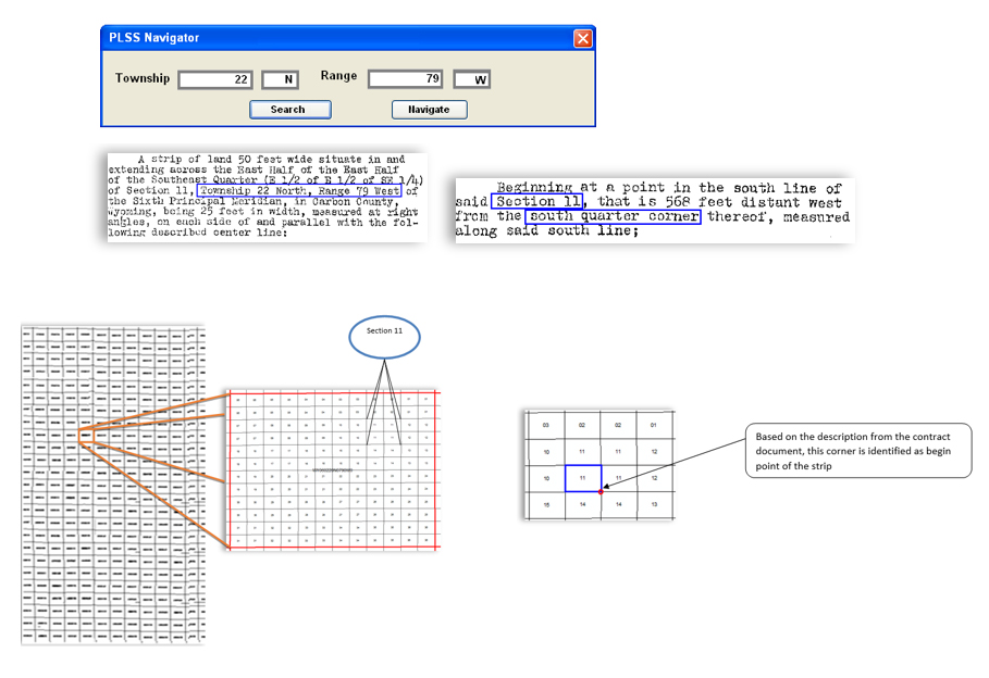
- Helps the users to accurately navigate to the correct Township section range grid
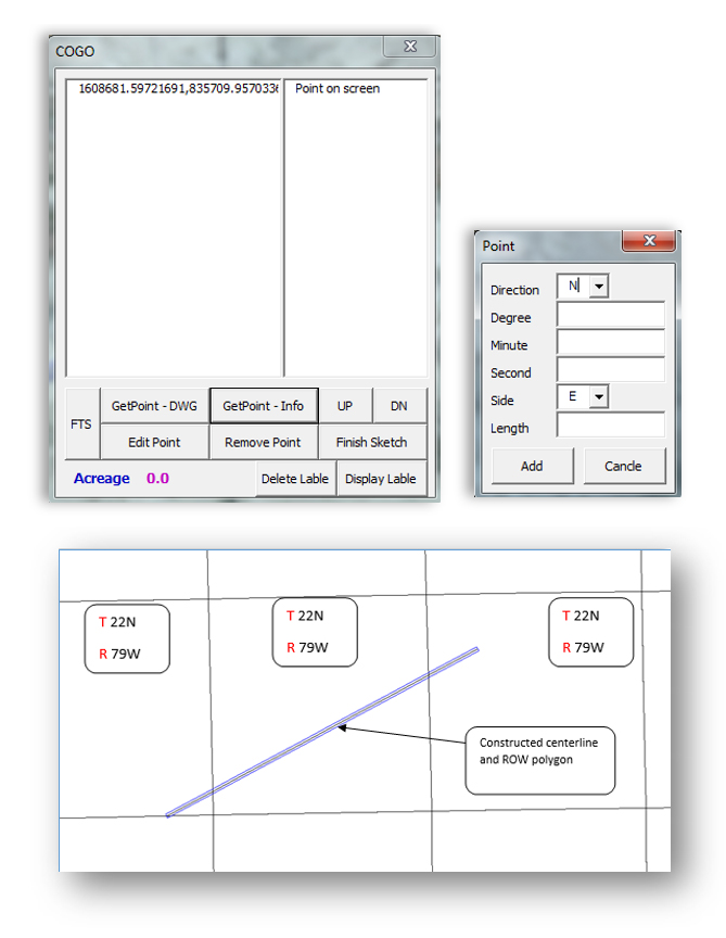
- Strip details (as shown on the contract agreement) can be directly entered into the application, which automatically creates the centerline
- The user just enters the strip width and the application automatically creates the strip polygon using the centerline and the width value
- As the centerline and the polygon are created by the customized tool, the error rate of the typo issue is less and the resulting data accuracy is more.
A brief overview of the applications is given below:
A. Navigation tools based on the Township range
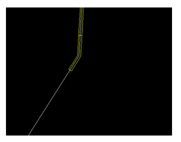
B. Centerline and ROW polygon digitization tool
A fully customized tool for the digitization of ROW centerline and permit polygon
C. Fully automated tool for the digitization of permit polygon from purchase report
Purchase report showing the parcel length to be created on the centerline (sample shown below) with information about the begin station and end station, row width.
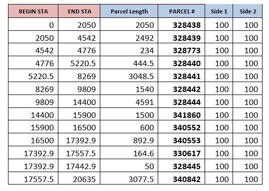
The tool created purchase polygons based on the above table
How does this solution help utility companies?
- Quick access to the records and fast retrieval of legal documents
- Accurate information for corporate real estate research with online system access for the parcel rights information with graphical representation
- Effective vegetation management
- Clarifying landowner queries online within a quick turnaround
- Reduced survey time for planning and new construction
A single digital source for researching right of way data and information, as well as, a method for displaying graphical representations of the data via mapping applications, promotes visualization techniques to communicate anticipated project impacts. It also helps in land acquisition for new constructions, reducing penalties due to insufficient or incorrect information and quick query clarification to various departments.
Parcels mapped from various sources like purchase reports, permit/easement/ agreement documents
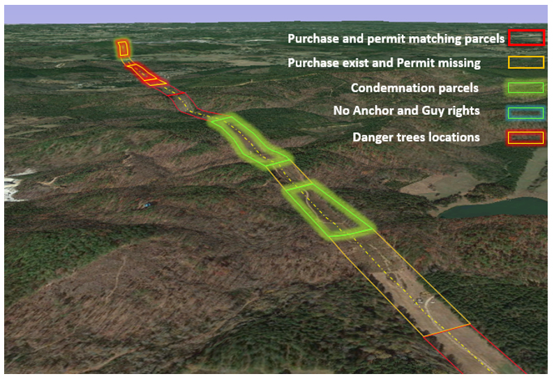
With more than two decades of experience, RMSI has helped a leading US-based electric utility company with an effective Right of Way (ROW) management. Our experts transformed the clients physical deeds and agreement records into digital intelligent records. The solution developed ROW database using ESRI GIS-based technology for about 11,000 miles of transmission network corridor.
RMSI undertook this project and helped the client in establishing a single GIS-based digital system that helped in:
- Consolidation of various permit level legal documents stored in different locations
- Analyze every document in detail for necessary rights such as adjacent guy rights, ingress/ egress, station details encroachment issues, etc.
- Bring in owner, beginning, and end station details with improved encroachments
- Identifying anomalies between various permission reports
- Developing a single digital source for right-of-way research with graphical representation