Looking through the news channels for information on the rain showers that occurred in Delhi NCR in the second week of June due to the wind circulation brought on by Cyclone Biparjoy, I came across images of extensive traffic jams and roadblocks. This heavy 2-to-3-hour jam resulted from 15-20 minutes of heavy showers. It makes me wonder why such seasonal and unseasonal-period rains bring havoc to the city. Are the towns not prepared for heavy rainfall? Why do they experience traffic jams and roadblocks even with a relatively short duration of heavy showers?
Delhi NCR regularly grapple with urban flooding and frequent flash floods after short rains. What’s happened in the city is nothing unique; most urban clusters face the same problem.
What is Urban Flooding?
Floods in urban areas are often caused by a combination of factors, including heavy and frequent rainfall, storm surges, sudden water release from dams in higher catchment areas, and excessive snow melting, leading to flash floods in lower catchment areas.
- In today’s time, urban flooding is generally a result of encroachments on natural drainage areas like lakes and wetlands, which reduces the flow of water along the drainage network causing floods. Bengaluru and Delhi are amongst the best example of such encroachments.
- Another common cause behind urban flooding is the excessive pollution of water bodies choking up the paths for the water to flow. Water bodies are filled with non-biodegradable waste, pointing to poor solid waste management of municipal bodies.
- Unplanned development and construction activities in floodplain areas are also major reasons behind urban flooding.
- Uninformed release of excessive water from the upper catchment
Urban flooding ranges from highly localized incidents to major incidents, resulting in cities being inundated from hours to several days. Therefore, its impact can also be widespread, including temporary relocation of people, infrastructure damage, risk of epidemics, shortage of water supplies, and long power cuts.
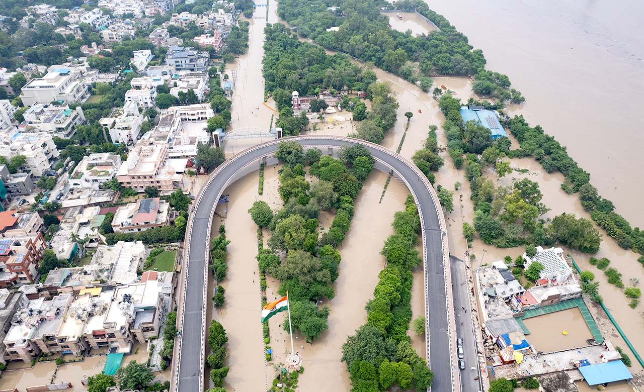
Recently Delhi Floods are another example, where the city was flooded for more than 4-5 days. Though there are multiple reasons behind Delhi being impacted by Urban floods, incessant rains in Himachal Pradesh and Uttarakhand led to increased water levels downstream of Haryana, releasing water from Hathnikund Barrage. This water release from Hathnikund led to a rise in water levels of the Yamuna River to 208.48 meters around Delhi. After reaching Delhi, Yamuna water led to overflooding at the Old Railway Bridge because of the natural drainage encroached by continuous development around the low-lying areas of Delhi. Figure 1 indicates the water discharges from Hathnikund and the simultaneous water level rise in Yamuna at Delhi.

After the water crossed the high flood level, all the low-lying areas near Pragati Maidan, Outer Ring Road, Delhi Civil Lane Zone, Purana Qila Maidan, Kashmiri Gate, and Monastery Bazar area were flooded for at least 5-7 days. In Garhi Mendu and Usmanpur villages of North-East Delhi, the water level has risen over 4 feet leading to forced power cut-off to avoid any casualties due to electrocution. This indicates an urgent need for planning to prevent future flooding. Rather than constraining the river, the government should explore ways to create space for the river to spread, and the easiest way is by de-silting the Yamuna and its tributaries and distributaries, especially around bridges, canals, and brooks. Moreover, seeing the frequency of urban flooding events in Delhi, there is a need to implement a flood forecasting system to monitor the flood situation.
Economic Impact of Flooding in Delhi
Our initial history lessons emphasized the importance of rivers in the development of a city and the economic activities around it. Delhi is bestowed with the River Yamuna, which has made it a major city since ancient times. As India gained Independence, the areas around Yamuna were the first to develop.
The low-lying areas of Model Town, Yamuna Bazaar, Mayur Vihar, Kashmere Gate, Monastery, Geeta Colony, and Wazirabad developed as central markets and trading hubs. In today’s time, as the water level in Yamuna is swelling, these areas are most impacted.
The situation this year has been aggravated due to two reasons (a) a record rainfall of 153 mm of rainfall between 8th and 9th July 2023 and breaking a 41-year record and (b) the record release of more than 12 lakh cusecs of water from Hathnikund.
Such flooding resulted in long traffic jams and roadblocks, damage to assets such as basement, contents, furniture, fixtures, and equipment, business interruption due to stoppage of production, assets being non-accessible & closure of marketplaces leading to loss of income.
Long traffic jams and roadblocks after a short period of heavy rain showers, flash floods, and urban flooding can be attributed to a combination of factors such as unplanned urban development by the local authorities, changing global climatic conditions, improper and inadequate drainage capacities, and improper waste management.
The most common sources of economic impact of flooding are:
- Inundation of stocks leading them as non-usable
- Damage to assets such as basements, contents, furniture and fixtures, and equipment
- Business Interruption losses due to production being stopped, non-accessible assets, and closure of markets leading to loss of income.
- Loss of productivity due to non-availability of infrastructure and factors of production, e.g., power supply, water supply, labor shortage
- Interruption in the movement of goods and services due to blockage of multi-modal transport options such as roads, national highways, and railways
- Drop in government revenues due to lower tax collection such as toll, excise, GST, etc.
What can we learn from Tokyo’s underground water reservoir gates created to halt urban flooding?

An exemplary example of resolving the issue of frequent urban flooding conditions in the country is Tokyo’s underground temple water gates. Tokyo had critical flooding issues, and the lower city’s shallow surface elevation was lower than the sea level. Tokyo City had already lost millions due to flooding and massive damage to buildings, infrastructure, and houses. Citizens had to relocate constantly every year. Thus, the authorities created vast underground water reservoir gates to protect the city from drowning during flash floods. It is the world’s largest underground floodwater diversion facility (Popularly known as Underground Temple) located in Showa in Tokyo. It aims to protect the city from floods during heavy rainfall and typhoons. This underground tunnel channels the overflowing flood waters from rivers to 5 concrete containment silos through tunnels that are 65 m deep and 32 m in diameter. Water from these connecting tunnels is then sent to the vast underground water storage tanks, when the silos reach capacity, and then pumped out into the Edogawa River at a lower altitude in the city’s outskirts. This facility is dry during the dry seasons, serves as a tourist spot, and can be accessed through staircases fixed to the silos.

The example of Tokyo suggests that tackling requires immaculate planning, coordination, and execution at various levels, from the top to the local city level. It involves coordination between urban planners, municipal corporations, public works departments, utility providers, and other key stakeholders. Post-execution also requires regular maintenance and upkeep of projects, along with strict adherence to SOP is the only way to prevent periodic catastrophes.
Conclusion
Urban flooding is a serious threat to the lives and livelihoods of millions of people in India. It causes damage to infrastructure, disruption of businesses, and loss of lives and property. The effects of climate change only worsen the situation as extreme rainfall events become more frequent and intense. Therefore, India must adopt innovative and effective solutions to prevent and mitigate the impacts of urban flooding.
India is now the third-largest economy in the world in PPP (purchasing power parity) terms; fifth largest in terms of the exchange rate; India has also jumped to 40th rank in the global innovation index. With a global positioning like this, India has the potential and the resources to become a global leader in tackling urban flooding. It has a strong economy, a vibrant innovation ecosystem, and a dedicated disaster management framework. It needs the government’s focus to make urban flooding a priority issue. By doing so, India can protect its people, environment, and future.
Some of the possible solutions are to emulate the example of Tokyo, which has built a massive underground reservoir system to divert excess water from the city; to invest in disaster management authorities and task forces that can monitor and maintain dams, levees, drains, and flood plains; and to enforce strict regulations on urban planning and development, especially in high flood hazard zones. These measures would reduce the risk of urban flooding and enhance the resilience and sustainability of India’s cities.
Impact and Flood Forecasting Systems should be encouraged in metro cities to help prepare for and reduce the effects of flooding on infrastructure. It provides information about the likelihood and severity of flooding, which can give people time to mitigate, plan, and prepare in advance.