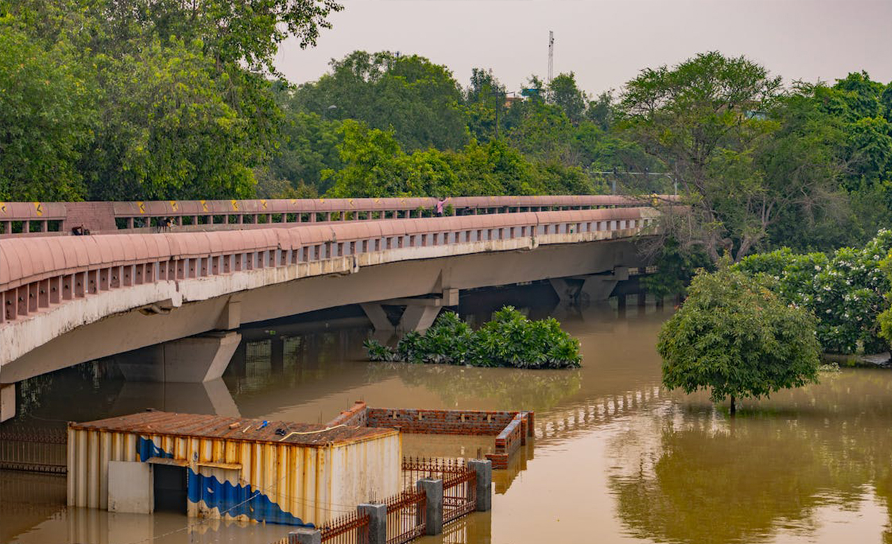
This monsoon in Delhi has witnessed a lot of unexpected chaos in the National Capital due to heavy rains and the release of water from upstream (i.e., Hathnikund Barrage), causing much suffering to Delhiites living near the Yamuna River banks. Some technical glitches in flood regulation gates (especially at the ITO barrage) also aggravated the flooding situation in the city.
Usually, I take the metro’s blue line route(Delhi NCR), which travels from Mayur Vihar to Yamuna Bank, giving a reasonably good view of the Yamuna River and its floodplain. Every year during the rainfall season, I see how the river swells up (reaching around 208.66m HFL mark) during the months of July and August 2023. The vast land, otherwise green and spotted with small huts, was now an extended span of muddy water with whirlpools flowing swiftly. The scene was a bit scary to see, though. While I glanced through the fast-moving metro window, I recalled some of the history lessons from school: many ancient civilizations were formed and flourished in the rivers and also became history due to the significant flood events.
The Yamuna’s floodplain in Delhi is around 97 square kilometers, or 7% of the city’s area, according to the Delhi Development Authority’s 2021 Master Plan for the town. But much of this has been encroached upon by settlements and large development projects, which have hindered its free flow; as a result, the runoff has increased in proportion to the urbanization of the watersheds, causing flooding in Delhi. Several low-lying areas in the city close to the river, including the Boat Club, Monastery Market, Yamuna Bazaar, Geeta Ghat, and the stretch from Majnu Ka Tilla to Wazirabad, were flooded with the river water.
Understanding floodplains and their management
The floodplains, otherwise the land relatively flat adjacent to the riverside, have a lot of significance in the river ecosystem. Floodplains are very important hydrologically and ecologically and perform many functions, including flood protection, erosion control, improved water quality, recharged aquifers, and improved wildlife habitat. However, land developers, city administrations, and even the general public often see the river floodplains as an easy-to-access resource for development, either legally or illegally. In the long run, the investment in floodplain construction only imposes a penalty instead of any dividend.
There are mainly two schools of thought when we look at floodplain management options – “Room for River” and “River training”.
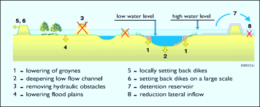
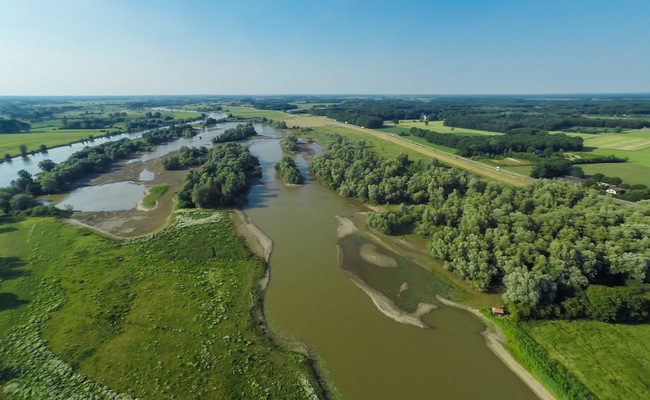
Room for the River is a government design plan intended to address flood protection, master landscaping, and improving environmental conditions in the areas surrounding the Netherlands’ rivers. Room for the River uses a ‘working with nature’ strategy. It advocates giving space for rivers to flow naturally, and the floodplains act as cushions to absorb the impact of floods. Eight different Room for the River measures (Silva et al., 2001) are:
Many countries, including the United States, Australia, United Kingdom, Denmark, Germany, and other Southeast Asian countries, are adopting the Room for the River concept for floodplain management. River training includes stabilizing a river channel for the river to run quickly and exit, particularly the human settlement areas. Some of the main components of river training works are – marginal embankment (dyke or levee), Guide bunds or banks, Afflux bunds, Groynes or Spurs, approach embankment, etc.
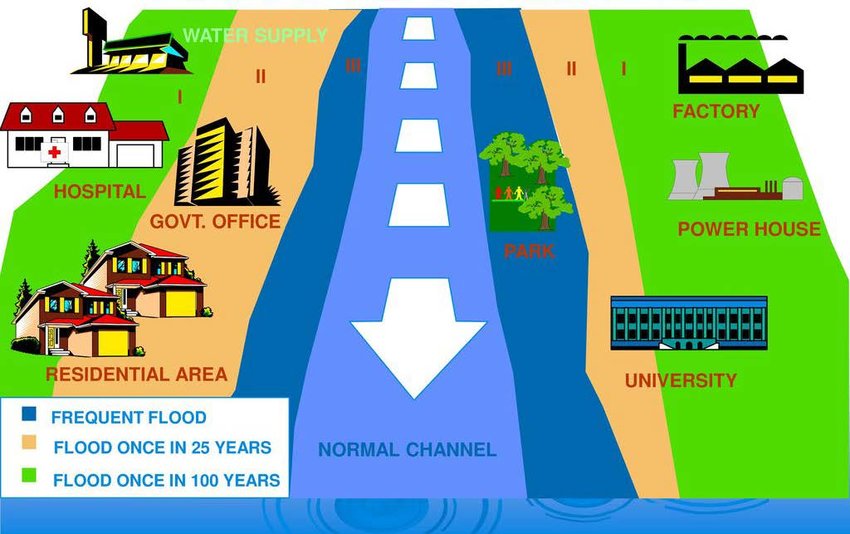
Floodplain zoning is another way to regulate land use and restrict construction activities in floodplains. India has national floodplain zoning guidelines (issued by the National Disaster Management Agency, NDMA) in place, and some states have taken initiatives to restrict the development of floodplains. The floodplain zoning policy advocates development zones and permissible activities in different flood-prone zones. Cities, in particular, find it challenging to implement this flood zoning due to community resistance and the high demand for land for construction work.
However, before recommending any option for floodplain management, understanding the river characteristics, including the quantity of water flows during different seasons and the adjacent land use, needs to be considered. For this, understanding flood behavior is essential. One needs to analyze the return period of different intensities of the river flood and advocate the right mix of interventions.
So how can we strike a mid-way between “room for the river,” “river training,” and floodplain zoning?
It is crucial to understand the flood characteristics of the river and develop high-quality flood hazard maps for different return periods. Under sustainability practices, RMSI models flood hazards for various return period events for other rivers of India and abroad. The flood hazard maps developed by RMSI are utilized by different agencies in flood mitigation and flood plain zonation.
An innovative approach to managing floodplains – A success story
RMSI recently completed a similar floodplain zoning project in Meghalaya State following the NDMA guidelines (2010) to demarcate areas in prohibitive, restrictive, and warning zones along the four river stretches. As part of the project flood mitigation plan, options for flood mitigation measures were also developed. The suggested measures will help the client minimize flood risk in the project areas and reduce the adverse effects of floods on nearby habitations to meet the objectives of the National Hydrology Project. The client can implement these measures on the ground in the project’s subsequent phases.
Conclusion
A balanced approach is crucial for our cities’ long-term sustainability and our communities’ well-being. By preserving floodplains and adopting sustainable practices, we can mitigate the risks associated with flooding while enjoying the benefits these valuable ecosystems offer.
City planners need to collaborate with environmental experts, engage in public consultations, and evaluate the prospective impacts before allowing any permanent floodplain development. Recognizing the importance of these areas in flood management, urban design, and biodiversity conservation is imperative to ensure a resilient and livable future for our cities.
Let us not repeat the mistakes of the past and instead pave the way for a sustainable and resilient future. By understanding and respecting the role of floodplains, we can strike a harmonious balance between urban development and environmental preservation. Together, we can create cities that thrive amidst the challenges of climate change while safeguarding natural resources and prioritizing economic growth.
In my next blog, I will share key strategies for urban floodplain management.