
Today, utilities face the challenge of improving spatial accuracy and data integrity of network assets when aligning them to real world systems. Quality and accuracy of geospatial datasets not only possess significant constraint at the time of modernizing or transforming utility commodity services such as increasing demand, generation, transmission, and distribution but also inherits serious consequences on reliability of the information when dealing with safety risks and take suitable operation actions to mitigate them.
Conflation – Aligning Datasets to Improve Spatial Accuracy
Thinking spatially, conflation or disambiguation is an approach that can be adopted whenever there is confusion in identities of two or more places, sharing similar characteristics of each other, until there seems to be only a single identity. The ultimate objective of conflation is to retain accurate data, minimize redundancy, and resolve data conflicts, by aligning geospatial datasets of different accuracy levels.
The conflation process involves a set of standard frameworks consisting of:
- Feature matching: Find a set of conjugate point pairs, termed as control point pairs, in two datasets,
- Match checking: Filter inaccurate control point pairs from the set of control point pairs for quality control, and
- Spatial attribute alignment: Use the accurate control points to align the rest of the geospatial objects (e.g., points or lines) in both datasets by using space partitioning techniques (e.g., triangulation) and geometric interpolation techniques.
Conflation Automation
When one talks about conflation automation (referred here as shifting technology in geospatial context), it includes employing cutting-edge conflation techniques for compilation or reconciliation of geographic information from two different geospatial datasets covering overlapping regions.
Fundamentally, conflation techniques can be categorized into three groups based on the types of geospatial datasets dealt within GIS (Geographical Information System) domain.
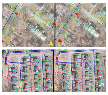
- Vector to vector: A typical example is the conflation of street centerline with respect to satellite / aerial images. Figure 1 shows another scenario of utility assets conflation; where conflation of ‘overhead (OH) and underground (UG) electric utility networks’ is achieved
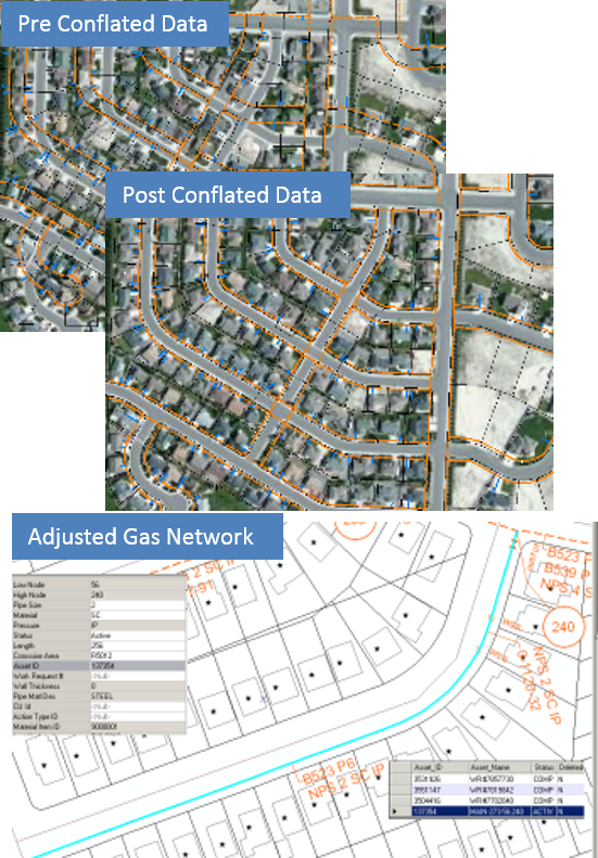
- Vector to raster data conflation: Figure 2 shows practical example of adjusted gas network as a result of conflation in street intersections of a facility (Gas) network from asset data and landbase image.
- Raster to raster data conflation: Involves warping maps pixels within each triangle to the corresponding pixels on imagery based on Delaunary triangles and rubber-sheeting techniques, as described by Ching-Chien Chen – 2005.
Advances in Automated Conflation Technology
First Saalfeld, in 1988 laid the foundation of conflation automation (vector to vector), by investigating the techniques to automatically construct the influence regions around the control points, to reposition other features into alignment by appropriate local interpolation techniques.
From then, various vector to vector conflation techniques have been proposed by Ware and Jones in 1998, Walter and Fritsch in 1999 and many GIS systems such as [Conflex (http://www.digitalcorp.com/conflex.htm)] and [MapMerger (http://mapmerger.com/)] have been developed to achieve the alignments of geospatial datasets.
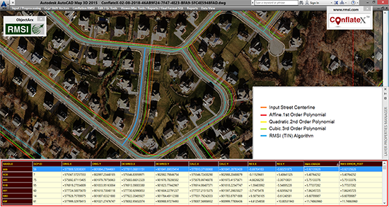
In year 2011, RMSI developed [ConflateX™ (https://www.rmsi.com/products/conflatex/)] an auto data conflation tool, which is a feedback driven solution envisioned to address the key business challenges of improving spatial accuracy and data integrity of network assets by aligning them to a more precise and accurate real world system. Figure 3 presents a synopsis of the result achieved during an automated street centerline conflation test by utilizing different algorithms.
Recently, Serguei Sokolov – 2017 filled a US patent for ‘’method and system for conflating raster and vector data’’ to preserve accurate relative location information between vector and raster data sources during non-linear transformation. In a method according to this invention, raster and vector data are received that corresponds to maps and conflated in a multi-step process (http://www.freepatentsonline.com/9558574.pdf).
Considering the above scenario, progressive utilities as part of their digital transformational journey, are taking up ambitious projects such as grid modernization programs, software infrastructure projects, where advanced automated conflation tools are playing a vital role by providing large volumes of spatially accurate datasets.
Very informative article