
Utilities tend to reduce the number and severity of vegetation-related outages and improve safety and network reliability to cut overall maintenance costs. Hence, vegetation management is evolving rapidly with emerging technologies such as LiDAR and satellite imaging, revolutionizing manual inspections and data collection tasks.
LiDAR Market Scope:
The global LiDAR market is witnessing rising revenues and is forecasted to reach USD 5.8 billion, growing at a compound annual growth rate of 22.1% by 2030. Also, Industrial Vegetation Management will grow at a CAGR of 4.52% by 2025, as per the report by SpendEdge. LiDAR technology is used in a wide range of geographic and environmental monitoring applications, like land management & planning efforts, geologic mapping, forestry, agriculture, hazard assessment (landslides, lava flows, tsunamis, floods, and more), and watershed & river surveys. In airplanes and helicopters, LiDAR platforms are predominantly used for acquiring LiDAR data over broad areas.
LiDAR market is segmented into –
- Technology segment – into1D, 2D, and 3D
- Product type segment – terrestrial LiDAR, airborne LiDAR, and others
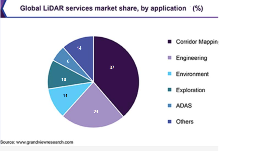
- Functional area segment – ADAS & driverless cars, cartography, corridor mapping for utilities and communications, meteorology, urban planning & environment, engineering
- Component segment – positioning and navigation systems, laser scanners
LiDAR for Utilities Management
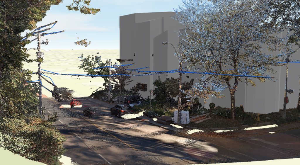
LiDAR technology has been used to manage utility asset data for over a decade. It has been proven to be a beneficial tool for identifying and extracting information pertaining to vegetation management along the utility infrastructure by providing an accurate geographical representation of objects on the earth’s surface.
RMSI offers processing of high-precision LiDAR managed services combining GIS and street-level Imagery with AI and ML technologies to automate data processing and visualization tasks. In addition, it delivers analytical outputs in computer-aided design (CAD) and geographic information system (GIS) formats.
RMSI LiDAR domain experts have been performing asset data extraction that involves capturing the overhead distribution assets, road infrastructure, and vegetation cover along the utility right-of-way by combining the 360o Imagery and LiDAR data with machine learning and AI algorithms. A few of the asset types we typically extract include:
- Assets on power poles
- Pad mount transformers and communication boxes
- Third-party attachments
- Vegetation near power lines
- Water Hydrants/valves
- Road infrastructure, including Signboards, Highway overpass heights
The data extraction process leverages complete automation and is proven at scale for utility networks encompassing thousands of miles, drastically reducing manual efforts. The extracted data also helps in assessing the condition of the assets and identifying locations of hazardous vegetation along the transmission or distribution network.
Vegetation Management Analytics
RMSI’s Vegetation Management analytics includes analyzing the processed 360° imagery coupled with LiDAR and providing actionable insights to support vegetation encroachment detection and removing dangerous trees along the utility right-of-way corridors. These analytics provide a detailed dataset of the vegetation positioned along the roadside surrounding the utility assets in a comprehensive visualization model that significantly helps in faster decision-making. Each vegetation dataset captured provides corresponding GPS locations (XYZ) of each feature extracted.
- Provides a highly accurate and efficient output compared to traditional inspection methods
- Supports spatial analysis from clusters of derived hazard encroachment points to enhance vegetation management planning/tree trimming cycles
- Helps in field management for Routine Compliance and Enhanced (EVM) Risk Reduction programs
- Minimizes engineering costs, and time-to-market is improved with a reliable schedule
Pole inventory and Pole Loading Analysis
Utilities have a tough time tracking and verifying the attachments on single-use or joint-use poles, and things are almost constantly changing in the field. As a result, they could not determine if their inventory of billable attachment assets on utility-owned poles was accurate, potentially leaving a substantial amount of unbilled revenue on the table annually. A manual “boots on the ground” approach is painstaking, expensive, and time taking.
Our LiDAR-based managed service offerings help inventory the critical assets on the poles by combining the datasets captured from 360° imagery + LiDAR along overhead distribution poles and other assets with GIS. Further, RMSI helps to reconcile the actual attachment data with the GIS and ERP system records to determine the number and type of unbilled attachments.
- Precise network asset and condition info extracted with advanced analytics
- Identification of the geometry of conductor lines to determine location and length
- Prescriptive results on the record of poles, conductor lines, and fuel load rate
- Resolving the overload cases after attaching the proposed third-party attachments
- Asset survey, make-ready, pole loading, and extension audit for joint-use
- Enhanced Asset risk assessment and compliance verification
The Way Forward – LiDAR-based Automated Vegetation management solution
Having worked with several customers, RMSI is developing a complete cloud-hosted solution that leverages LiDAR, Artificial Intelligence (AI/ML), and GIS technologies enabling utility service providers to regularly assess the state of vegetation in the vicinity of their assets. This solution identifies those high-risk circuits or corridors that will most likely be impacted by vegetation overgrowth, delivering actionable insights to take immediate remedial action.