
India received 759.4 mm of rain during monsoon season this year; 87.4% of the long-period average and the lowest since 2015. June delivered 65% of normal, July 101%, August 84%, and September 92%. This year was marked by highly variable rainfall across the country, with considerable differences in rainfall distribution among regions and months.
During June 2026, the country received 106.8 mm of rainfall against the normal of 165.3 mm, resulting in a 35.4% deficiency. Rainfall improved considerably during July, when the country received 283.3 mm, nearly the normal rainfall of 280.5 mm, with a 1.0% excess. Rainfall again remained below normal during August and September. The country received 213.3 mm in August against the normal of 254.9 mm, a 16.3% deficiency, while September received 155.1 mm against the normal of 167.9 mm, a 7.6% deficiency (Table 1). By mid-October, summer monsoon haswithdrawn from most of the remaining country, including the southern peninsula.
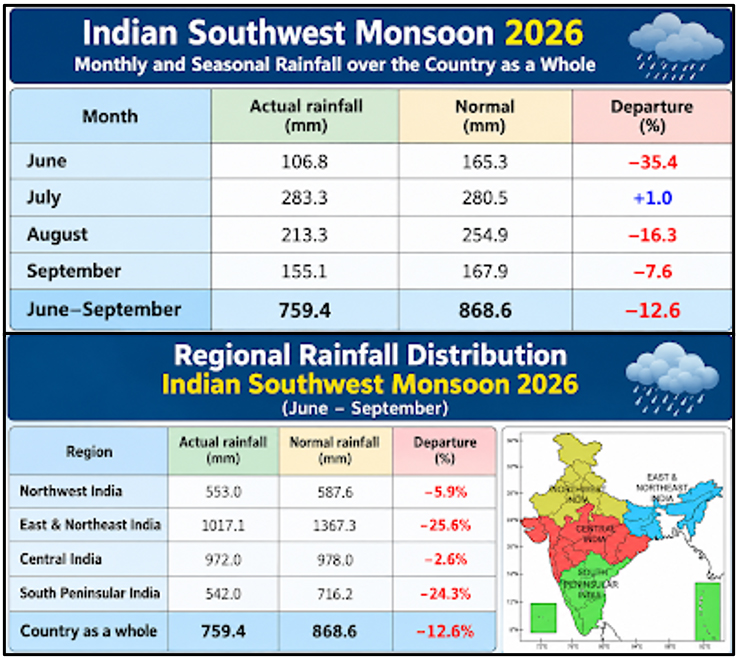
Across India, prolonged dry spells were interrupted by intense cloudbursts, creating a paradox of drought, flash floods, groundwater stress, crop losses, and urban flooding—all within the same season. The year 2026 has experienced a record warming of the eastern and central Pacific in the form of super El Niño, a developing positive Indian Ocean Dipole, and a warming of the western Indian Ocean relative to the east, which draws moisture towards the subcontinent. Cumulative rainfall for the country during summer monsoon season is about 13% below normal. The southern peninsula ended 24.3% short of seasonal normal rainfall. The share was 79% in western India and 65.7% in the south.
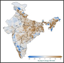
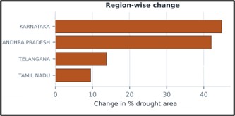
An interesting aspect of this year’s monsoon performance is also that the number of dry days throughout the monsoon season was considerably less across India in line with that has been observed during the past 75 years, a warming climate-induced signal in changing pattern of monsoon rainfall over India (Figure 1). The state-wise percent change in agricultural drought index due to deficient rainfall during monsoon season this year in key South Indian States, as estimated by ICAR-IARI are as depicted in Figure 2.
The withdrawal of the southwest monsoon is closely associated with the transition toward the northeast monsoon over the southern peninsula. The retreat of summer monsoon season by mid-October brings a reversal of circulation under the influence of Northeast (NE) monsoon which is an important source of rainfall during October–December.
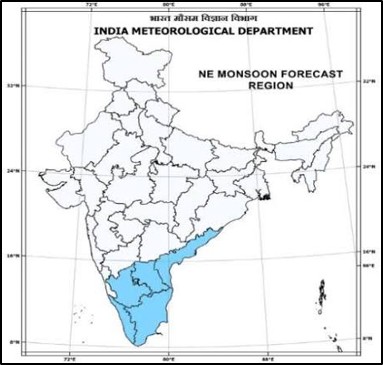
Northeast monsoon is a part of northeast trades and is dry, stable, and has less vertical extent compared to southwest monsoon. This region consists of five meteorological subdivisions viz., Coastal Andhra Pradesh, Rayalaseema, South interior Karnataka, Tamil Nadu, and Kerala (Figure 3). During the NE monsoon season (between October and December), the winds turn northeasterly, cross the Bay of Bengal and pick up moisture, through which India receives about 11% of its annual rainfall, while many of the above-mentioned subdivisions receive 17–49% of their annual rainfall. There is a good influence of NE monsoon rainfall (NEMR) on agricultural production over south peninsular India. The inter-annual variability of NEMR is significantly influenced by ENSO and this relationship has been strengthened during the recent years due to the stronger easterly wind anomalies and anomalous low-level moisture convergence.
During October to December, the South Indian peninsula transitions from the withdrawal of the southwest monsoon into the Northeast Monsoon, which brings essential rainfall primarily to the eastern and southern coastal states like Tamil Nadu and parts of Andhra Pradesh, Kerala and Karnataka. While rabi crops rely heavily on stored or canal irrigation, South India (particularly Tamil Nadu and parts of Andhra Pradesh) receives critical rainfall from the Northeast Monsoon during October–December. This window marks the major sowing period for the Samba/Rabi rice crop and winter pulses.
South Indian States cultivate rice heavily during this season, utilizing northeast monsoon rains in coastal Andhra Pradesh and Tamil Nadu. Maize (Corn) is also extensively sown and cultivated during the Rabi window, notably achieving massive acreage in states like Telangana and Karnataka. Seed spices like coriander and fenugreek have their main sowing windows across southern plains during October and November. Perennial and plantation crops—including coffee, tea, and rubber across Kerala, and Karnataka—undergo regular estate management, harvesting (such as coffee bean picking starting around this time), and farmers also engage in desilting farm ponds, cleaning drainage channels, and managing tank-fed irrigation systems.
A weak or delayed NE Monsoon would lead to severe moisture stress, stunting young Rabi crops and dropping yields for maize and rice while intense, cloudburst-style heavy rains or cyclones common during the October-December window can cause waterlogging, soil erosion, and physical damage to mature or standing crops (such as cotton, paddy, and horticultural crops). It is thus very pertinent to explore what would be the outlook for this year’s NE monsoon rains, more so as the monsoon season rains have been substantially deficient in most South Indian States under the influence of record strength El Niño and other factors due to ongoing climate change.
August-September 2026 was the warmest period on record for the globe, eclipsing the previous tied records of 2023 and 2024 (Northern Hemisphere experienced its warmest summer). The three-month season was also record-warm. Global sea surface temperature reached an all-time high in August with the extreme weather events and climate disasters increasing in frequency and intensity all across the globe. El Niño conditions persisted during the month, driving record-high temperatures across vast areas of the central and eastern tropical Pacific Ocean (2.74oC as on 9th October 2026). The Atlantic and Indian Ocean basin have also continued to run hot over most of their area. Within the Indian Ocean, the El Niño interacts with another system, the Indian Ocean Dipole (IOD), which can either dampen or amplify El Niño conditions regionally.
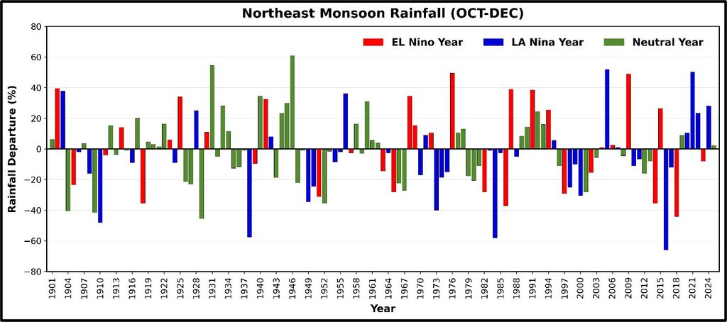
Over the Indian Ocean basin, significant southwestern Indian Ocean (SWIO) warming is induced by El Niño events which activate robust wind-evaporation-Sea Surface Temperature feedback during monsoon season. Higher moisture laden winds over India result in heavy to very heavy rainfall spells but the number of rainy days is suppressed. The four biggest east Pacific El Niño events, 1982-83, 1997-98, 2015-16 and 2023-24 suggest a decline in NE-Monsoon rainfall over Southern India. A similar record is observed in 7 of 8 Niño years, when September through December was drier than the median neutral year in all eight past strong events, and in six of them it was drier than any neutral year in the record (Figure 4). But this year’s forecast models disagree about it (5 of 13 show a wet signal). The main effects of the El Niño are expected to be felt in the northern hemisphere (including India) from November 2026 onwards and well into the next year.
RMSI’s seasonal forecast based on analysis of several dynamical and thermodynamical parameters (Niño 3.4 Sea Surface Temperatures, Southern Oscillation Index, North Atlantic Oscillation, Indian Ocean Dipole, and strength of upper air east-west trough) influencing the circulation over South Peninsular India during September-October this year, suggests that, in 2026 during NE-Monsoon season, rainfall would be deficient by 12%-18% in Karnataka and Tamil Nadu while Andhra Pradesh and Kerala would experience 10% to 20% increase in rainfall against the normal (~90% probability).
Multiple heavy to very heavy rainfall spells with more than average number of thunderstorms and lightning during the season are likely in some districts of coastal Andhra Pradesh, south Tamil Nadu and Kerala. More than 2 severe cyclones originating in Bay of Bengal could hit east coast of India and at least one in Arabian sea could graze through western ghats of India during November – December this year. Sri Lanka is likely to experience (+85% probability) severe flooding events at a few locations along its east coast during this season.
This outlook suggests that the sowing and development of rabi (winter-sown) crops, particularly paddy, maize, coconut, and cotton could be adversely affected this year and would require developing diversified strategies for agricultural operations and decision making in agriculture and water resource sectors in South India.