
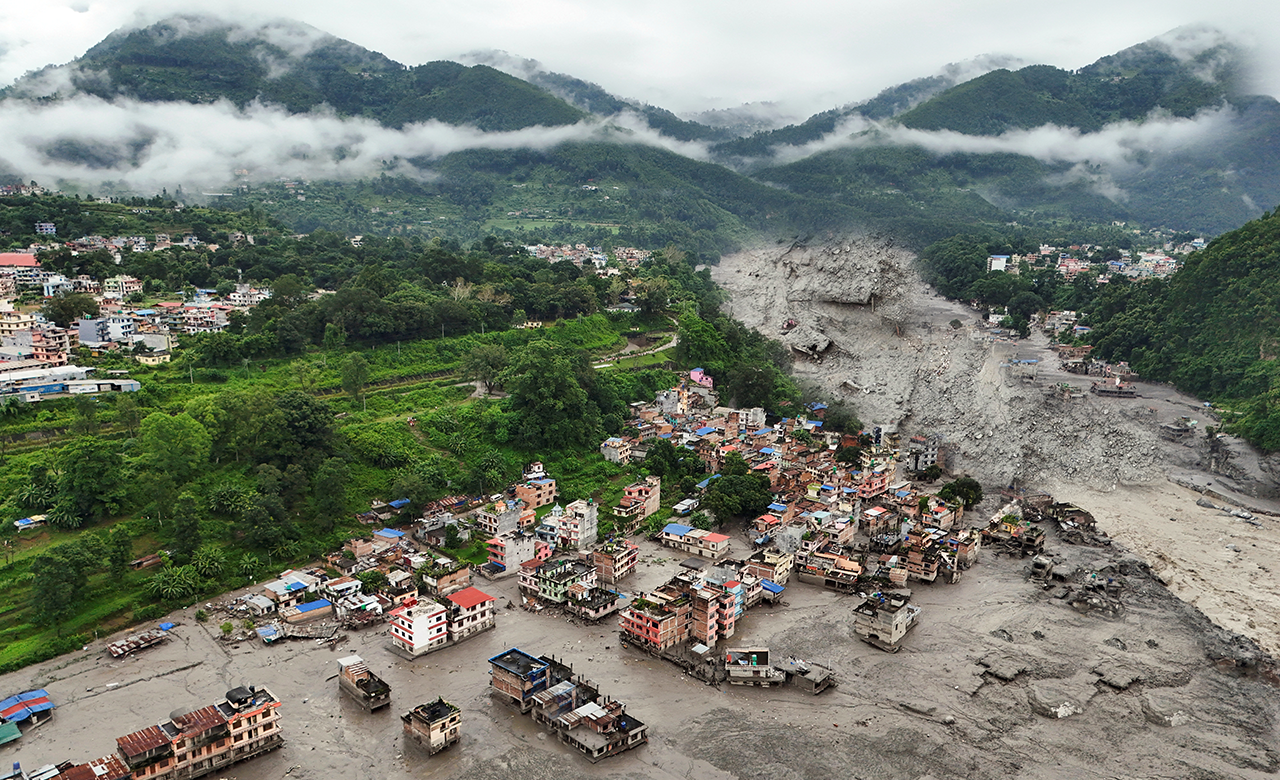
Nepal’s avalanche due to massive rock landslide with a entrained small section of glacier ice between the peaks of Langtang Lirung (7,227 meters) and Tsangbu Ri (6,781 meters) was caused by the collapse on the morning of 26th August 2026. The piled up debris tumbled down vertically below 1200 m and slammed into a tributary of the Bhote Koshi River in China-Nepal border region. A giant hunk of glacier peeled off the side of the mountain and a wall of rocks and muddy water blasted through the Gyriong Port building crossing (or Rasuwagadhi) at 80 to 100 m high (based on Landsat 9 and SRTM terrain data), and at a speed of around 180 kmh-1 as the catastrophic flood barrelled down the valley sweeping away riverbank settlements along more than 100 km, leading to the loss of countless lives (close to 1050 dead and 4500 including 583 foreigners and 83 security personnel still missing after a week; 11,814 people have been rescued thus far, while thousands remain unaccounted for as 22,000 security personnel and at least 16 helicopters continue searching affected areas and hydropower tunnels) and critical infrastructures (Figs. 1 & 2). Authorities in Nepal are now burying hundreds of unidentified victims in a mass grave as efforts continue to identify bodies and reunite them with their families. Entire settlements in Timure, Syabrubesi and parts of Rasuwa, Nuwakot and Dhading were erased in minutes. Roads, bridges, schools, homes and markets were swept away. At least six major hydropower and transmission facilities were directly impacted: Rasuwagadhi, Chilime, Trishuli 3A, Trishuli 3B/Hub 220kV substation, Trishuli Hydropower Station and Devighat. Collectively, this has knocked roughly 430 MW off the national grid. India’s specialised tunnel rescue team has made some progress at two hydropower sites in flood-hit Nepal, establishing a foothold inside a tunnel at Chilime and probing up to 185 metres at Langtang. A thermal drone was sent into a tunnel in Nepal‘s Rasuwa district – part of a hydropower plant devastated by the Bhotekoshi flash flood.
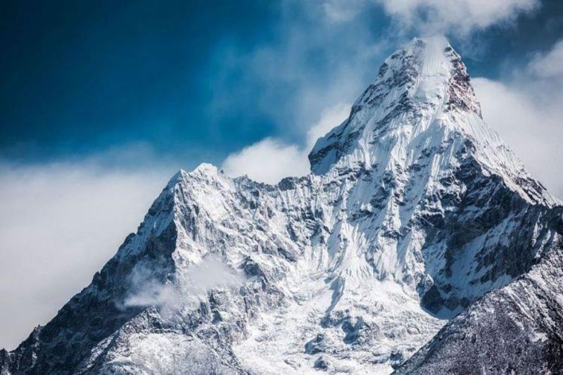
This unprecedented catastrophic disaster can at best be described as ROCK SLOPE FAILURE ? MAJOR ROCKSLIDE ? GLACIER ICE ENTRAINED ? DOWNSTREAM FLOODING. In India also, the Kosi river and its tributaries are bursting their banks and flood waters have reached danger mark at multiple locations. In contrast, the destructive flash floods and debris flow in Kedarnath (2013), Chamoli (2021), Sikkim (2023), Dharali (2025) in India were triggered by intense rainfall and cloudbursts in the surrounding Himalayas which is fundamentally different and explained as CLOUD BURST/INTENSE RAINFALL SPELLS ? OVERTOPPING GLACIAL LAKE ? LAKE/DAM FAILURE ? OUTBURST FLOOD (GLOF). Interestingly, determining where a rock slope might fail, when it might fail, and how large the resulting failure could be remains extremely challenging — and in many situations is not currently predictable with sufficient reliability. Of course, ice can play a structural role in stabilising some high-altitude rock slopes (Fig. 3), so changes in glacier and permafrost conditions may influence slope stability.
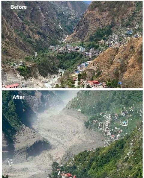
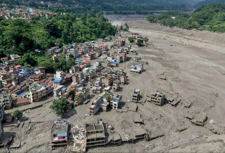
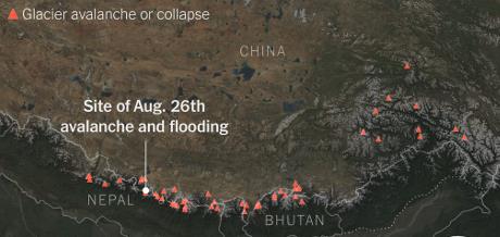
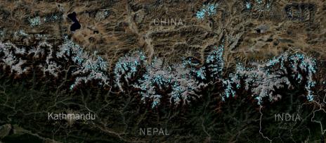
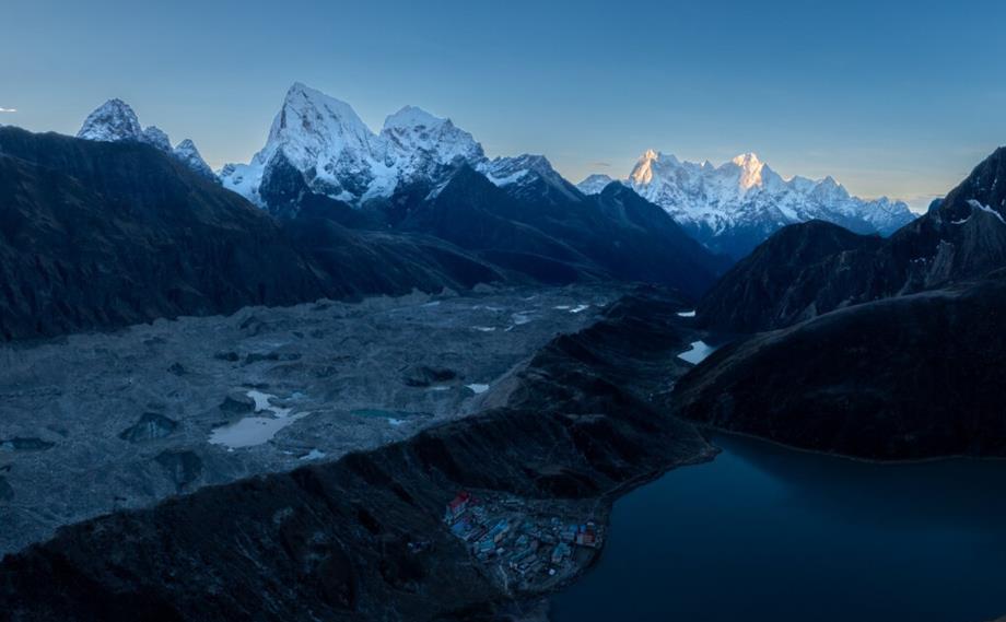
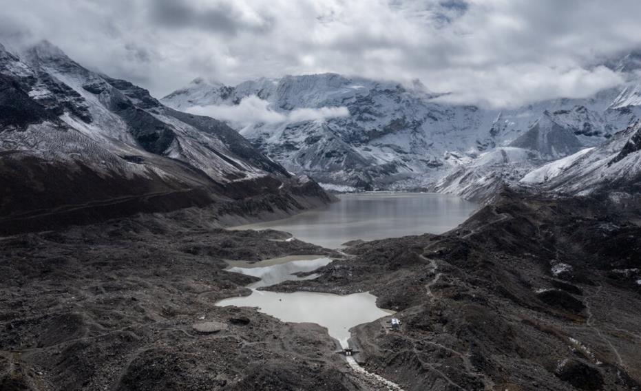
History reveals that glacial failures — the scientific term for a category of events that includes ice avalanches, glacier detachments and rock-ice avalanches — have happened dozens of times since 1900 in the China-Nepal border region that was the site of this devastation (Fig. 4). Glacial lakes have broken their banks in Nepal more than 20 times since the early 1960s (Fig. 5). Three of those incidents have been in and around the Everest region. In 2024 also, a landslide had smacked into a glacier in the Khumbu region, launching a flood wave over the moraine dam that sent 100 million gallons of water through the heart of Thame, a Sherpa village nearby when the flood had destroyed the village’s school, medical clinic, several lodges and homes. The Ngozumpa, Nepal’s longest glacier (a high-altitude glacial lake located at 4,950 meters in the Gokyo Valley of Sagarmatha National Park, was originally a long, ribbon-shaped puddle, near the Sherpa village of Gokyo about 20 years ago, became a lake nearly 230 m wide, measuring about 36 km long and covering an area of roughly 79 km2 in 2025 (Fig. 6). It is blanketed by thick, rocky debris shed by adjacent mountains. Silt and mud trapped by meltwater here has turned lake water a dark grey colour which heats up the water in the lakes to melt the surrounding ice. Imja Glacial Lake, a rapidly expanding meltwater lake located at the foot of the Imja Glacier in the Everest region at a elevation of 5,010 meters above sea level was formed in the 1950s and 1960s as glacier ice melted and collected behind a terminal moraine. About 8,976 feet long, 2112 feet wide and more than 400 feet deep it is one of the largest, and one of the most dangerous glacier lakes in Nepal (Fig. 7). The only thing holding it back is an unstable dam of ice, sand and rock. Because it is held back by an unstable natural dam of ice and loose debris, it poses a severe Glacial Lake Outburst Flood (GLOF) hazard to downstream Sherpa villages by flooding downstream settlements, trekking trails and bridges. In 2016, the Nepali Army and local workers constructed an outlet channel to safely drain millions of cubic meters of water, lowering the lake level. But this as well as many of the lakes are said to be filling up fast because of accelerated melting of glaciers amid rising global temperatures.
Stretching over 3,500 km2 across eight countries including India, Nepal, Bhutan, Pakistan, China, Afghanistan, Myanmar and Bangladesh, the Hindu Kush Himalaya region is a vital ecological zone. It supports over 240 million people directly and up to two billion people downstream, providing water, food and energy security. HKH holds the largest volume of ice outside the poles, feeding at least 10 major river systems across Asia. The rivers of Nepal contribute about 40% of the average annual flow in the Ganges Basin, which alone is home to over 500 million people, about 10% of the total human population of the region. Water from both permanent snow and ice and seasonal snow is released by melting, some are temporarily stored in high altitude wetlands and lakes, but most flowing directly downstream in the large river systems, giving a distinct seasonal rhythm to annual stream flow regimes in these rivers. Global warming in this region (warming in the greater Himalayas has been much greater than the global average) is having a severe impact on the amount of snow and ice, which has serious implications for downstream water availability in both short and long term as up to 50% of the average annual flows in the rivers are contributed by snow and glacial melting. The current trends in glacial melt suggest that the low flow will become substantially reduced as a consequence of regional climate change which would adversely impact food production and economic growth in the most populated areas of downstream region in perhaps a few decades when the river basins run out of water during the dry season.
Over 50 million people live directly within the Himalayan mountain range, where around 15,000 glaciers exist. Since 1975, Hindu Kush Himalaya (HKH) glaciers have lost 27 metres of ice, 12% of their area and 9% of their ice reserves as the planet has warmed and temperatures across the Himalaya have soared. Air over HKH has warmed at a rate of 0.26oC each decade from 1951 to 2020 and at the even higher rate of ~0.5 oC per decade at elevations higher than 4,000 meters. Higher elevations of the Tibetan Plateau (>4 km) have experienced stronger warming due to a phenomenon alluded to as Elevation Dependent Warming. Rising temperatures are melting glaciers faster than ever-forming unstable glacial lakes that can burst without warning thus raising flood risks. The HKH have also experienced a significant decline in snowfall and glacial area in the last 4–5 decades. In the past two decades, ice mass in the region has retreated at @0.3 to 1 m year-1, faster than the world average. The thinning rates of glaciers outside ice sheet peripheries has doubled over the past two decades (mean elevation change rate is reported to be
13 – 15% between 2000-2020). The glaciers have shrivelled, and those moraines have trapped meltwater creating lakes (Fig. 8) that grow until a disturbance causes them to drain catastrophically.
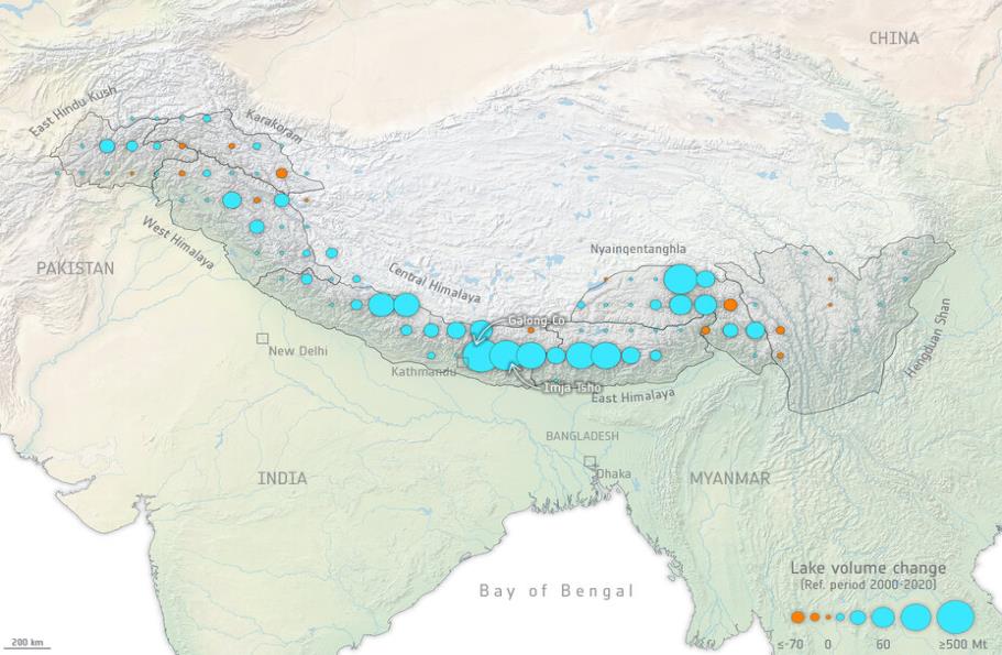
While smaller glaciers, particularly those under 0.5 km², are shrinking the fastest, increasing the risk of local water shortages, meltwater pooling behind moraines and in depressions exposed by the ice will transform thousands of glaciers into large lakes, each one a potential ticking time bomb for cumulative and cascading landscape risks for vulnerable communities downstream. Temperature projections for the 21st Century suggest a significant acceleration of warming over that observed in the 20th Century (could warm by 3.6oC by 2100 under SSP2-4.5 scenario & by 5.2oC under SSP3-7.0 with progressively higher warming with higher altitude). In Himalayan highlands, it is very likely that it would be most significant in the interior including the Tibetan Plateau. A greater proportion of total precipitation in the last few decades appears to be falling as rain than before. Even though heavy rainfall episodes have been reported in Himalayas, the assumed linear relationship between rainfall extremes and cumulative anthropogenic CO? emissions expressed as Radiative Forcing is not a law of nature and its validity over a longer period of time cannot therefore be taken for granted. However, while the retreating glaciers have destabilised surrounding slopes which has given rise to catastrophic landslides resulting in damming of streams and often leading to outbreak floods. Excessive meltwaters, often in combination with liquid precipitation, also triggers flash floods and/or debris flows. Changing Dynamics of Glaciers in the Hindu Kush Himalaya Region could have severe consequences for communities depending on glacier-fed rivers like the Indus, Ganges and Brahmaputra.
Asia’s Indus and Ganges-Brahmaputra basin – fed by the Himalayan, Karakoram, Hindu-Kush, and Ladakh ranges – are the most important storage unit on the planet. Its waters, produced at high elevation from rain and snow, and draining from lakes and glaciers, support more than 200 million people settled across parts of India, Afghanistan, China and Pakistan. One of the defining aspects of the Asian water towers is the way they are able to maintain essential water supplies to populations even in drought years through the steady melt of high-elevation ice in summer months. The Brahmaputra had greatest total glacier mass loss (?4.87 ± 1.01 Gt yr?1), followed by the Indus (?3.53 ± 0.97 Gt yr?1) and Ganges (?3.19 ± 0.58 Gt yr?1).
India is projected to experience the most critical increase in water gaps under warming scenarios. In a 1.5°C warmer climate, India will have an additional 11.1 km3/yr water gap. Water gaps are expected to increase the most in the Ganges-Brahmaputra (5.6 km3/yr). In a 3°C warmer climate, India still presents the largest water gap increase (17.2 km3/yr) compared to baseline conditions (2001-2010). In a 3°C warmer climate, the Ganges-Brahmaputra basin presents the largest water gap increase (11.8 km3/yr) compared to baseline conditions, followed by the Indus (8.4 km3/yr).
These river basins are subject to a range of current and future pressures, from ever greater demand – for more drinking water, for increased irrigation and industry, etc – to issues that could severely curtail supply. Under the baseline climate, the largest water gaps are found in India (124.3 km3/yr). A warmer world will disrupt precipitation patterns and denude glaciers of their storage capacity. Over the next few decades, climate change is going to affect drinking water for people, water for power, water for agriculture – and in these water towers may not cope with the water demand to about 1.9 billion people. The effects of warming between 1.5 °C and 3 °C would be uneven, with the higher temperature scenario exacerbating issues like groundwater depletion, ecological stress, and unsustainable water use more severely.
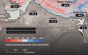
The highland regions of Himalayas (the most extensive and rugged high altitude areas on Earth) and its water resources play an important role in global atmospheric circulation, biodiversity, rainfed and irrigated agriculture, and hydropower, as well as in the production of commodities exported to markets worldwide. Most glaciers in the central and eastern Himalaya receive?80% of their annual accumulation from the summer monsoons. However, the snow anomalies in the region have reported significant negative snow anomaly even during winter season of 2023-24 (Fig. 9). The retreating glaciers of the Hindu Kush Himalayas could pose far-reaching threat to the region. With continuing warming, climate models project a continuing decline in snowfall over the HKH during the twenty-first century (the range of excess glacier meltwater runoff due to negative glacier mass balance in Indo-Gangetic basin constitutes ?23% of the total basin-specific glacier meltwater runoff). Higher rates of glacier and snowmelt in a warmer world would enhance stream flow and compound flood risk in the Himalayan river basins in the future in the absence of additional adaptation and risk mitigation measures. Significant declines in river flow are likely after glacial melt has run its course and the evapotranspiration impacts of increasing temperature begins to dominate (likely beyond 2060s).
Mass wasting is very wide spread constraint faced in all parts of the Himalaya. It is a general term to describe a variety of processes through which large masses of earth (soft sedimentary, foliated metamorphic or fractured igneous – severe freeze – thaw cycle leads to greater erosion of soil and rock formation) move downhill under gravity, both in slow creeping mode or as rapid landslides. Hydrological risks of mountain rivers involve hazards associated with the behaviour of snow and ice e.g. avalanches, glacier dammed lakes, large landslides, glacier outburst floods (GLOFS), surging mudflows should be considered before undertaking water resources developmental projects in high Himalayas.
Hydropower potential of Himalayan river systems is about 78% of the total Indian hydropower resources. This potential of Indus, Ganga and Brahmaputra river basins is assessed to be 19, 988, 10,715 & 34,920 MW at 60% load factor respectively. Mountain environment here is experiencing degradation in terms of accelerated soil erosion, landslides, and rapid loss of habitat and genetic diversity. For structural designing in the Himalaya, the implications of the resulting tremendous locked-in energy due to seismicity have to be taken into account in the light of progressive failures of slopes and the creation of landslides of large volumes. Whether it is road construction, or dam building or house construction, ground tremors and movements along the faults constitute a very serious constraint. It makes partnering with Nature increasingly a question of risk-resilience, strategic capital allocation and competitive advantage. Monitoring thousands of glaciers and lakes, strengthening hydrometeorological networks, developing multi-hazard early-warning systems and making infrastructure climate-resilient require resources and technologies that vulnerable mountain countries cannot mobilise alone. This is where Loss and Damage becomes a lived reality rather than an abstract negotiating concept. While keeping the 1.5C warming target requires rapid emissions reductions at the centre of global ambition, At COP31, mountain risks need greater visibility across these discussions.