
Summary
Development of web and mobile phone based agro-weather tool for dissemination of climate-information and weather forecast based best-bet agronomic management recommendations for farmers in Ethiopia and Kenya. The tool was developed by RMSI for the main cultivated crops in Ethiopia and Kenya. The disseminated climate and crop information helps farmers manage weather risks, maximize productivity, and minimize the environmental impacts of farming practices. In addition to the web-based application for agro-weather Decision Support System (DSS), the tool also offers an android phone app, along with an IVRS and SMS module.
INTRODUCTION
In developing countries such as Ethiopia and Kenya, farmers are ‘weather-watchers’. They use their prior experience to adapt their agricultural practices according to the changing weather. However, changing climate is affecting these age-old practices. Extreme weather events such as drought and flood are becoming more frequent with enhanced climate variability and climate change, and the damage that they cause to agriculture, human health, productive assets and infrastructure affects livelihoods long after.
Managing the risks associated with increasingly variable climate is essential for successfully adapting agriculture, and to reduce the cycle of poverty, vulnerability and dependence brought about by climate-related disasters.
A common problem in developing countries is the lack of integrated means of processing and delivering agro-meteorological information to the farming communities. Even with improved agricultural technology and improved level of farm inputs, the agricultural sectors in these countries operate below their potential level owing to the challenges imposed by marked intra-seasonal weather and inter-annual climate variability. These countries lack a formal system that integrates data from different sources such as agricultural research institutes, meteorological monitoring stations, agricultural advisory agencies and the actual ecological requirements. Now that farmers have access to modern ICT tools (web access and mobile connectivity), it can pave the way for agro-meteorologists to analyse weather and climate induced risks, and provide this valuable information to farmers on a real time basis through these channels. These tools can help assess climate impacts using crop–weather interactions for formulation of highly practical advice that could be shared with famers who can apply these directly to their operations in near real time. The internet provides free information to masses about climate and the environment, and increasingly accurate weather and climate predictions. However, there is a need to better translate this raw information into accessible forms that are understandable and relevant to agricultural decision-making. Innovative ‘agro-climate tools’ can bridge this gap of translating climate information into actionable climate knowledge.
They should address a range of climate-sensitive decisions spanning a range of scales, and generally must share two common features:
- Weather and climate data and critical extremes should be translated into estimates of impacts on various aspects of agricultural systems
- Decision-makers should be allowed to explore the risks and potential consequences of different decisions before they have to put their own livelihoods, or the livelihoods of others, on the line.
With the current global challenges of climate variability and climate change posing risks to food security, it is vital to develop appropriate agro-weather tools for disseminating information on farming practices and alerts, directing weather forecast related decisions during cropping seasons. This will help local and national authorities in unlocking the potential of climate-smart agriculture in developing countries.
Weather/climatic information plays a major role before and during the cropping season and if provided in advance, it can be helpful for the farmer in organizing and activating their own resources in order to reap the benefits. Agro-weather tools contribute to ‘climate-smart agriculture’ by closing the gap between climate information and effective action.
Agriculture represents a core part of the Ethiopian and Kenyan economy and provides food and livelihood activities to much of the country’s population. While the agricultural productivity varies greatly by region due to uneven impacts of daily, monthly and seasonal weather (intra-seasonal variability in temperature and rainfall), climate variability and climate change is expected to exacerbate the impact on agricultural productivity and could contribute to a possible shift in existing crop patterns. The policy implications are far reaching, as changes in agriculture could affect national food security, trade policy, livelihood activities and water conservation issues, affecting the society at large in Kenya.
Hence, appropriate tools are required to better translate raw weather and climate information into accessible forms for all stakeholders and particularly the farmers (preferably in vernacular languages) that are understandable and relevant to make decisions. By translating climate information into actionable climate knowledge, an innovative decision support system comprising an ‘agro-weather tool’ can facilitate farmers and extension personnel to better understand climate variability. Through increased relevant knowledge provided by the decision support system, and collaborative efforts, they can develop on-farm adaptation strategies that reduce potential loss to crops due to impacts of climate variability. It should address a range of climate-sensitive decisions for the best agronomic management practices. Such agro-weather tools are vital to unlocking the potential of climate-smart agriculture in developing countries as weather and climatic information plays a major role before and during the cropping season.
RMSI has developed a web and mobile phone based “agro-weather tool for climate smart agriculture” that incorporates climate-information and best-bet agronomic management recommendations for farmers. This tool, currently developed for the predominantly cultivated crops in the Ada’a district of Ethiopia and Embu district of Kenya, will help farmers manage weather risks, maximize productivity, and minimize climate driven risks.
USAGE
Approach to Develop Agro-advisories
The agro-weather tool developed by RMSI offers advisories for the pre-cultivation strategic choices and the tactical decisions to be made during the crop growing phases (i.e., post-sowing to harvest stage). Pre-cultivation and crop growing phase decisions are important because they cannot be postponed, (are often irreversible), represent a substantial allocation of resources, and have a wide range of consequences that impact farmers for years. Through this tool crop advisories (Wheat, Teff, Lentil, and Chickpea for Ethiopia and Maize, Sorghum, Bean, Coffee, and Tea for Kenya) can be generated and sent to the users (i.e., farmers and extension workers). It may be noted here that all these advisories are based on weather deviations in the cropping calendar under reference with respect to the climatological means of essential climate (weather) variables for the site (see Figure 1 and Figure 2 as example for wheat and bean crops cultivated in Ethiopia and Kenya).
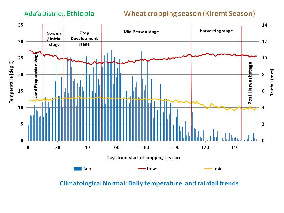
Fig 1: Climatological normal for Ada’a district of Ethiopia (daily temperature and rainfall trends) for Wheat production
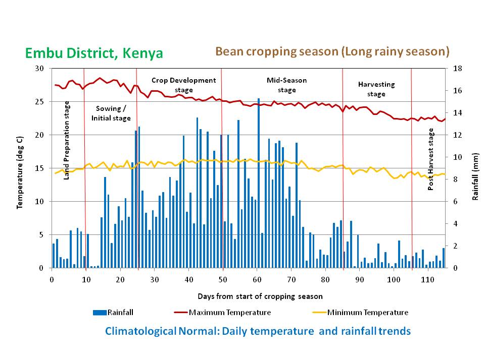 Fig 2: Long rainy season climatological normal for Embu district of Kenya (daily temperature and rainfall trends) for Bean
The agro-weather DSS tool aims at disseminating information on farming practices and alerts focusing on decisions linked to weather forecasts during cropping seasons for local application in Kenya and Ethiopia. RMSI first developed a database and a decision support model linked to climate information, which enables the identification of the most appropriate choices for field-specific climate-smart management practices, and a data/advisory delivery system for agronomic options. The crop-specific agro-advisories disseminated through the tool are generated using historical weather data, historical crop data, crop management practices, and DSSAT (Decision Support System for Agro-technology Transfer) crop simulation model. The tool sends vital information in a variety of formats and in a timely manner, thereby allowing farmers to better plan and manage weather risks and maximize productivity.
It addresses a wide range of climate-sensitive decisions for the best agronomic management practices and includes the following advisories for farmers:
- Advisory to plan for “Land Preparation and Crop Sowing Date” that is generated based on the “Rainfall Onset Date”. The purpose of this advisory is to inform the farmers to sow the seed at right time during the crop sowing window so that farmers can avoid the loss in the event of deficit or excess rainfall. This advisory is generated based on the seasonal rainfall onset date forecast. Two types of advisories are generated in this case: (a) advisory of land preparation start date and (b) advisory for crop sowing start date. For example, “if rainfall onset date is 15th June then farmers will get advisories like – ”Start land preparation from 10th June onward and start crop sowing from 16th June onward for lentil crop in case of Ethiopia”.
- Advisory for the selection of “Crop Type and Crop Variety” that is generated based on the “Seasonal Rainfall and Temperature Forecast”. The purpose of this advisory is to help farmers select the right crop and variety. This advisory will be generated based on the seasonal rainfall and temperature forecast. Types of advisories (in case of Ethiopia) which will be generated based on the seasonal rainfall and temperature forecast is given in Table 1.
Table 1: Advisory for crop type and variety selection based on the Kiremt season rainfall and temperature forecast
| Seasonal rainfall forecast (amount and duration) scenario | Types of advisory that will be generated against the season rainfall forecast information |
| Rainy season is likely to start early and the season will be longer | Go for long duration crops and varieties |
| Rainfall is likely to be normal (±20% of normal rainfall) | Go for conventional crops (e.g., wheat, chickpea, lentil, and teff) as rainfall is likely to be normal during upcoming Kiremt rainy season. |
| Rainfall is likely to be normal but duration of rainy season is likely to be shorter | Go for conventional crops (e.g., wheat, chickpea, lentil, and teff) but select short duration variety of these crops. |
| Rainfall is likely to be deficient by between -20% and -50% of normal rainfall | Either go for drought resistant variety of the conventional crops (e.g., wheat, chickpea, lentil, and teff) or go for sturdy crops only like teff, millet, etc. |
| Rainfall is likely to be deficient by more than 50% of normal rainfall | Go for sturdy crops only like teff, millet, etc. |
| Rainfall is likely to be in excess by more than 20% of normal rainfall | Go for excess water resistant crops like rice. |
| Seasonal temperature forecast scenario | Types of advisory that will be generated against the season temperature forecast information |
| Temperature is likely to be normal | Go for conventional crops (e.g., wheat, chickpea, lentil, and teff) subject to rainfall forecast, as temperature is likely to be normal during upcoming Kiremt rainy season. |
| Temperature is likely to be higher than the normal | Go for conventional crops (e.g., wheat, chickpea, lentil, and teff) but use heat resistant crop variety. |
- Advisory for the “Irrigation Application in the event of Rainfall Deficit or get ready to Drain Out Water from the Land in the event of Excess Rainfall” is generated based on the “Monthly Rainfall Forecast”. The purpose of this advisory is to avoid crop yield loss due to deficit or excess of rainfall in a particular stage of crop growth cycle. This advisory is generated based on the rainfall forecast. In this tool, this advisory was generated using crop simulation model DSSAT model.
This model was calibrated for all identified crops using historical weather data, crop yield data, and prevailing crop management Following the model calibration, artificial stress for water deficit (-25%, -50%, -75%, and -100% to normal rainfall) and excess water (> +20 to normal rainfall) was created for each phenophase of the crop (i.e., Initial Stage, Crop development stage, Early Mid-season stage, Late Mid-season stage, and Late-season stage) and crop yield was estimated using DSSAT model against each stress. Subsequently, irrigation option was used in DSSAT model to overcome the yield reduction against each water deficit stress.
Optimum water required to overcome the yield reduction against each stress was recorded and used in the advisory to be generated if such events are forecasted.
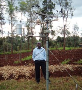
For example, if there is 50% water deficit during Late Crop development stage of Maize then user will get advisory like – “There is chance of water stress during Late Maize Crop Development stage. Apply 40 mm irrigation split over in 3 doses at the interval of 7 days”. Fig 3: Weather monitoring station
- Advisory to plan for “Fertilizer Application” generated based on the “5 Days Rainfall Forecast”. The purpose of this advisory is to avoid the loss of fertilizer due to heavy rain as sometime fertilizer gets leached out if it rains heavily after the fertilizer application in the soil. This can be avoided if farmers get advisory in advance about the probability of rainfall during the next five days. Besides, if it experiences light rain during the fertilizer application then fertilizer can be best utilized due to enrichment of soil moisture. This advisory will be generated based on the 5-day rainfall forecast throughout the cropping season. For example, if 5-day rainfall forecast says that “it is likely to be either sunny-day or light rain during 16-20 June” then farmers will get advisory such as – “It is ideal time to apply fertilizer if required” and if 5-day rainfall forecast says that “heavy rain is expected” then farmers will get advisory like – “Application of any fertilizer is not recommended during this week”.
- Advisory to plan for the “Harvest” generated based on the “5 Days Rainfall Forecast”. The purpose of this advisory is to alert the target farmers against the harvest related losses which may occur due to heavy rainfall immediately after the harvesting.

This loss can be avoided if farmers get advisory about the probability of rainfall during the harvest time. This advisory will be generated based on the 5-day rainfall forecast during the crop harvest window. For example, if crop sowing date is between 16-20 June then, the cropping calendar being 150 days for lentil crop, it would be harvested during 21-25 November.
Fig 4: Consultation Meet – RMSI expert interacts
with a panel of key stakeholders in Kenya
Hence, based on the rainfall forecast during 21-25 November farmers will receive advisory like – “Plan for the harvest during 21-25 November as it is likely to be sunny-day during this time period” (if rain is not expected) and “Harvesting is not recommended during 21-25 November” (if rain is expected).
- Advisory for “Likelihood of Infestation with Pest & Disease” generated based on the “Monthly Relative Humidity Forecast”. The purpose of this advisory is to alert the farmers against infestation with pest and diseases. This advisory is generated based on the relative humidity forecast information. In the advisory, all types of pests and diseases have been listed from the literature which might infest under the different relative humidity level. Additional information on choice of pests and diseases can be added in the list by the administrator according to their preferences at a later stage, if so warranted. For example, if relative humidity is between 70-80% the farmers will receive advisory like – “There is chance of infestation with Angular leaf spot, Halo blight, and/or Alternaria leaf spot during this month. Take appropriate action to protect the lentil crop against these attacks”.
In order to ensure that more number of farmers benefit from the agro-weather DSS tool, multiple delivery channels were developed for the dissemination of the advisories. The tool sends out the advisories at two levels, to users with access to the internet and to users with access to mobile phones (Android based or feature phones). The various channels developed for dissemination of information include:
- Web-based application: A web-based application which provides information on crops and location-specific farming practices and alerts on decisions linked to weather forecasts during cropping seasons for local application. This application was developed using Asp.Net 4.0, C#, .Net 4.0, JQuery 1.4.1, Knockout Js V 3.0.0, and Microsoft WCF, MVC and WPF. In this application PostgreSQL was used to store the database.
- Android phone app: An Android phone application was also developed to make the information easily accessible on a broader scale. Farmers and other users in the agricultural sector can access the outputs of the web-based application through the phone app, which provides all crop advisories directly to Android mobile phone users. Android framework and Java were used to develop this application
- IVRS and SMS module: In the same direction, an IVRS (Interactive Voice Response System) application and SMS module was also developed, which allows for crop-related advisories from the web-based application to be sent to other mobile phone users who do not have access to Android phones. Asterisk and Dialplan were applied to develop the Interactive Voice Response System IVRS.
BENEFITS
How the Agro-Weather Tool Benefits Farmers
The information and advisories provided by the agro-weather DSS tool benefits farmers in the following manner:

- Better planning and management of crops to overcome the weather risks;
- Maximizing crop productivity under the backdrop of climate change;
- Minimizing the environmental impacts on farming practices due to climate change;
- Devising and adapting new strategies for achieving greater climate resilience in agriculture.
Fig 5: Consultation Meet – RMSI expert interacts
with a panel of key stakeholders in Kenya
This agro-weather tool is relevant far beyond the two African nations it is currently implemented in, considering the fact that for the most important cereal crops, it is the developing world where production is likely to be impacted by 2050. It is a tool that might well be replicated in other parts of the developing world with substantial benefits for local farming communities from the withering effects of climatic vagaries.
WAY FORWARD
Agro-meteorological services in developing countries have to shoulder greater responsibilities due to larger population pressure and changing modes of agricultural practices. The future will see a constant increase in demand from the farming communities for agro-meteorological information, on technologies, farming systems patterns and practices, water management, weather based pest and disease control etc. In order to meet the future challenges, a ‘bottoms-up’ approach will be required, so that forecast-based agro-advisories and contingency planning serve even the small farmers for their planning and day-to-day agricultural operations. The ultimate goal of using all agro-meteorological information is to improve and protect the livelihood of farmers in terms of increasing yield quality and quantity, thereby establishing a self sufficient economy in the agricultural sector. Since agriculture is a powerful engine for the economies of developing countries’ (e.g., Ethiopia and Kenya) and it provides food and income to a vast majority of people in these countries, using agro-meteorological information in this sector has supreme importance for establishing sustainable food security in these countries.
During the last decade, grain yields have remained stagnant in most African countries because of high temporal rainfall variability, significant spatial soil nutrient heterogeneity, and weak and volatile markets. This combination calls for location-specific interventions that are aimed at enhancing farmers’ capacity to buffer water variations and address nutrient deficits. A massive investment in agriculture is indeed required, primarily focused on the creation of knowledge that does justice to the local variation in water and nutrient availability. It should aim to empower farmers to experiment and be innovative, and reinvent agricultural extensions and agricultural engineering in line with the changing climate landscape. Using agro-meteorological information has thus gained paramount importance in order to cope more effectively with climate variability and minimize losses in agricultural production.
Agro-meteorological information is part of a continuum that begins with scientific knowledge and understanding and ends with the evaluation of the impact and adaptation. Intermediate processes are collection of data, changing data into useful information and dissemination of information. In principle, these advisories represent the expert knowledge of the national meteorological agency and national agricultural research institute for all the countries in their capacity to provide the rural communities and farmers the opportunity to assess extreme events and disasters in a historical perspective. Agro-meteorological information and advisory systems can contribute effectively in the decision making process, provided they are streamlined to meet the specific needs of policies and farmers and are delivered in a timely and user friendly format. In order to make this tool usable by the farmers and extension workers most effectively, a well equipped, decentralized system for agro-meteorological and remote sensing data handling (to support real time rainfall monitoring), crop modeling, processing and analysis, as well as information product generation compatible with relevant background databases, need to be operational on real time basis. The agricultural institutes would need to regularly focus on improvements in the content and present information in their countries’ agro-meteorological bulletins. Improving the content of these bulletins will facilitate timely and efficient decision making for operational farms.
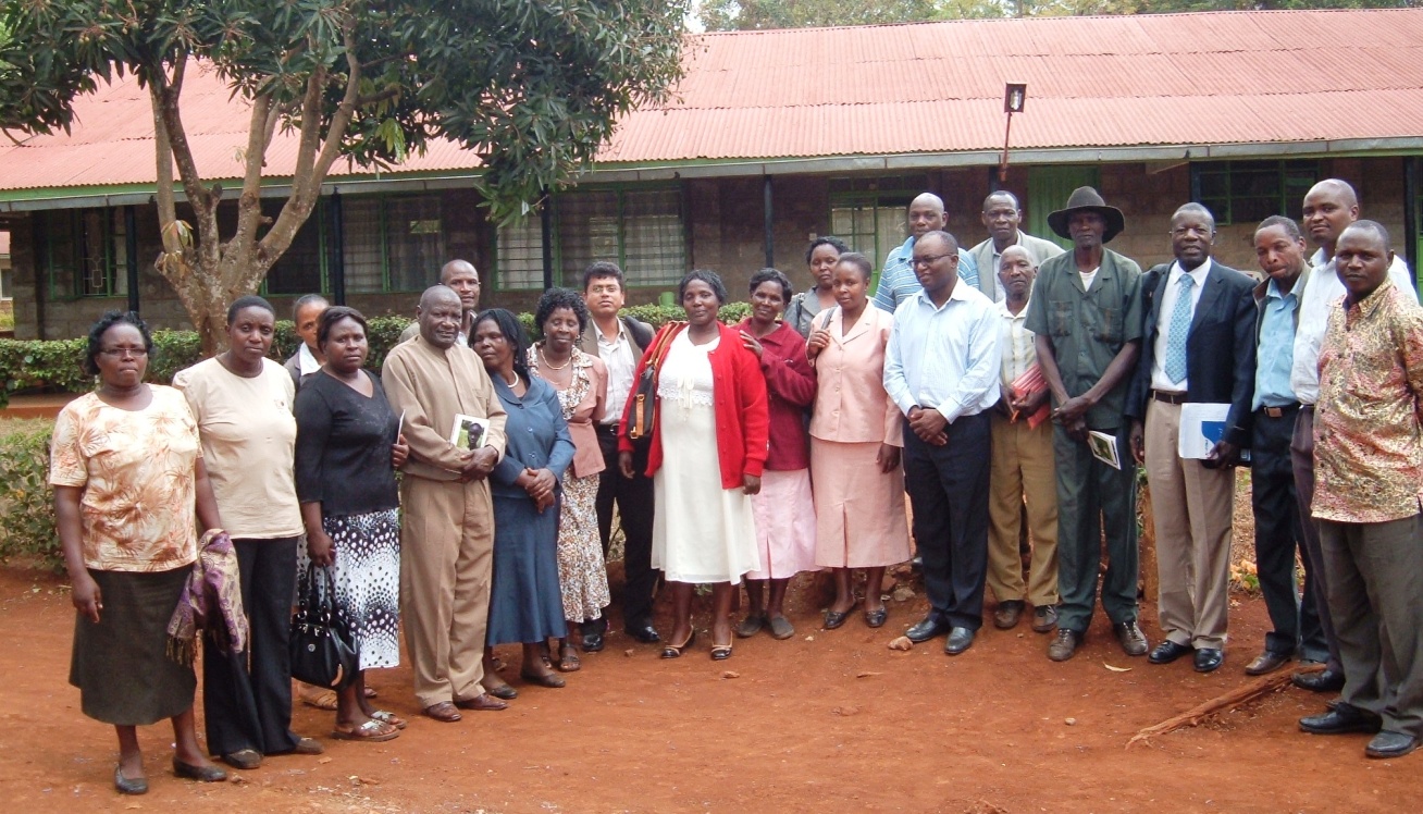
Fig 6: RMSI’s Focused Group Discussion with agricultural experts, meteorologists and the farming community in Kenya
Internet will play a major role in agro-meteorological information either through direct or indirect access. The effectiveness of ICTs for agro-meteorological information dissemination can be enhanced by linking them to other communication media, especially media which are more accessible to farmers such as mobile, radio, and TV and the use of local languages. In this way, a “multiplier effect” can be achieved. Evaluation of impact of information quality, usefulness, and its delivery systems must be undertaken by surveys and through the use of focus groups and innovative end-users (alternatively, develop a monitoring and evaluation tool for obtaining the user feedback on the agro-meteorological products directly through web service). The training needs of end-users and of the various intermediaries that provide them with advisory service, is also crucial. The specific survey instrument or the techniques for gathering information may differ from community to community, but the goal should essentially be the same: to evaluate the impact of information and the information delivery system and to have a quantifiable basis to improve the system. Included in this survey should be a brief on changes in positive behaviour (impacts) as this may positively influence government funding or funding from other sources. While it is true that information and communication technologies will improve in the future as will accessibility, the generation and dissemination of agro-meteorological information in the future will improve only with continued interaction of people, from scientist to extension worker, in the continuum from basic understanding to practical applications. Thus, to prepare for the future now, the country shall have to better integrate the human capital available at all levels of organization.
Impacts of climate change, occurrence of extreme events, changing temperatures, unpredictable seasonality and other stresses are emphasizing the need to redefine the way in which we understand and approach development challenges. Ensuring food security amidst a changing climate is at the top of developing countries’ agendas. Within resource-dependant contexts affected by more frequent and intense climatic manifestations, redefining the approach to food security involves embracing the notions of change and transformation. This includes the adoption of climate-resilient practices, the use of emerging tools, and technologies in close association with proven indigenous knowledge to better prepare for, withstand and recover from climatic aberrations.
The agro-weather tool developed by RMSI is targeted for the dissemination of information on farming practices and alerts focusing on decisions linked to weather forecasts for enabling farmers to protect their crops against the weather vagaries, and thus sustain the livelihood of rural farming communities. This web and mobile-phone based agro-weather tool, which incorporates climate-information and best-bet agronomic management recommendations, will help farming communities to plan and manage weather risks, maximize productivity, and minimize the environmental impacts. In addition to the web-based application i.e. a key part of the tool, the integrated voice and SMS solutions should also find more future users with the increasing use of mobile phones. The SMS platform is designed to be used for alerts, targeted to provide farmers with specific information, which will allow for easy adoption and create further demand for such agro-meteorological tools. The voice solution could by far be the most promising platform for farmers as it is customized for language, and is readily accessible. On making a call, farmers are automatically connected to an IVR (Interactive Voice Recording), which will prompt them to get critical information in either English or their indigenous language (e.g., Oromiffa and Amharic in Ethiopia and Kiswahili in Kenya).
The next priority objective should be to critically consider up-scaling scenarios and move from pilot program to the actual Climate Information Service Program for more wide-spread application of this agro-weather tool.