
With the advent of modern GIS technology, humans have made a major shift from the times of carrying a map in the pocket, to now having it all on the smartphones.
GIS or Geographical Information System, is a framework for gathering, managing, and analyzing all types of geographical data and with time has also transitioned from its old techniques to modern age GIS. Modern GIS is an integration of standard GIS functionalities with technologies such as Internet of Things (IoT), Machine Learning, Deep Learning, Artificial Intelligence, etc. that helps in providing more precise, accurate, and efficient mapping and navigation solutions.

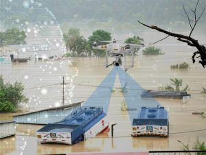
In the last decade, the use of GIS has grown exponentially from mapping and planning to predictive analysis tools. GIS is no longer a vertical but a horizontal, applied across all sectors and doing wonders especially in the field of Disaster Management.
A disaster is a sudden, calamitous event that disrupts the functioning of a community or society causing human, material, economic or environmental losses; losses that exceed the community’s or society’s ability to cope even with its best available resources. These unavoidable situations highlight the requirement for diverse, dynamic and advanced mechanisms for disaster management. Mechanisms that can identify areas vulnerable to destruction and finding unique ways to reduce susceptibility to extreme damage.
GIS Saving Millions by Managing Disasters
Floods, Cyclones, Earthquakes, Avalanches, GLOF’s, and Droughts are some of the many disasters, you may know. Since these disasters are location based, the spatial analysis tools in GIS help to manage them effectively. GIS enables planners and disaster managers to view spatial data through computer programs and provide outcomes that were not obtained with standard procedures.
Disaster Management is important to safeguard not just humans on earth but also the environment, wildlife, and humanity. Having said that, it is very important that we realize, managing a disaster involves rigorous efforts, lengthy procedures and great minds for its effective and efficient management, and this is where modern GIS steps in. This kind of management involves the collection, storage, and analysis of billions and billions of data units. Big Data integrated with GIS plays a pivotal role in making the disaster management process simpler and easier for the organisations managing this data.
In the current scenario, the world is relying greatly on leading technologies such as the Internet of Things (IoT), Deep Learning, Machine Learning, and their applications have been helping solve major disaster-related crises. Let’s know a little more in detail about some of the most impactful technologies:

Internet of Things for Disaster Management
Worldwide, IoT is being used to connect sensors and get spatial information from the ground, on the fly, into the system to develop better databases for site-specific and real-time data preparedness and planning. Devices and networks are being developed across the globe, to mitigate the impacts of future natural disasters and help deploy early warning systems.
Disaster prediction is more than just studying weather changes and patterns. It involves identifying hazard areas and potential zones on maps, facilitating communication through platforms that don’t depend on cellular networks or landlines in the event of a natural disaster, identifying population and built up area at risk on ground, etc. The sensors deployed play a critical role in getting results in the aforementioned processes.
 Big Data in Disaster Management
The numerous data units obtained from IoT based systems and other sources, put into analysis, help identify the specific mobility support or resources that responders can apply to the population hotspots.
Big data-based disaster management helps in predicting events in real-time, enabling proper mitigation and planning measures, and in making real-time assessment of the situation once the event has occurred. The key objective is to minimize harm to life, property, and environment.
Machine Learning for Disaster Management
Machine learning is an application of artificial intelligence (AI) that provides systems the ability to automatically learn and improve from experience without being explicitly programmed. GIS helps in providing the training data to standard modeling approaches, thereby helping them learn and perform better. For e.g. At a landslide location, ANN (Artificial Neural Network)-based models help in providing results with quantitative accuracy patterns which when compared with actual landslide locations have proven themselves to be quite efficient.
 How RMSI is helping clients and countries demystify disasters globally?
At RMSI, we have been using standard modeling techniques for more than a decade and it is now being transitioned into combining the same modeling techniques with Big Data and IoT based Machine Learning algorithms to provide better and precise results to our clients globally. Earlier, the models used to be probabilistic which has now taken a leap into forecasting risks. RMSI has been providing solutions to the Government of India and countries across the globe with technical/financial assistance from multilateral funding agencies.
If you find my blog interesting, read more about such technologies and applications in my next in the series.