
Many countries across the globe are facing the harsh realities of the environment. This has severely impacted the availability of basic necessities, such as freshwater, food security, and energy. Climate change has also increased the frequency of extreme weather events such as floods, droughts, and heatwaves.
Kuwait is no exception to this phenomenon. The country is regularly affected by environmental and climatic hazards such as drought, sand and dust storms, & flash floods. Moreover, technological hazards such as oil spills and air pollution, and emissions have added to the woes. This has increased the vulnerability of the local population, ecosystem, infrastructure, livelihood, and the economy towards such hazards. Inadequate early warning systems and unplanned infrastructure make it difficult to mitigate and manage such risks.
In collaboration with the World Bank, the Kuwait Institute of Scientific Research (KISR) initiated a study for assessing the macro hazards in the entire State of Kuwait, with a specific focus on the populous Kuwait City. This study will act as a precursor for comprehensive disaster risk assessment and management.
Assessing the hazard occurrences
Addressing the environmental, climatic, and technological challenges is critical for a country’s economic competitiveness and sustainable development. To understand the nature of the hazard occurrence over years, a detailed assessment of primary hazards was initiated to help develop a robust disaster risk management system for future.
RMSI conducted a detailed study to develop a national level hazard profile and identify existing geospatial data and its gaps for exposure and vulnerability assessment.
The hazards considered for Kuwait, with a focus on Kuwait City, were flash floods, sand and dust storms (including sand encroachment), drought, air pollution, and oil spills. The following process was initiated for the hazard assessment:
- Flash flood hazard assessment: Developed a probabilistic urban flood assessment model and provided an in-depth analysis of historical flood events and existing stormwater capacity.
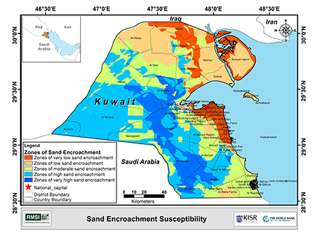
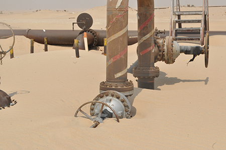
- Sand, dust storm, and sand encroachment assessment: Developed and mapped scenarios for sand and dust storms resulting in sand encroachment. As part of the model, the encroachment rate, direction, source, and magnitude for various scenarios were analyzed.
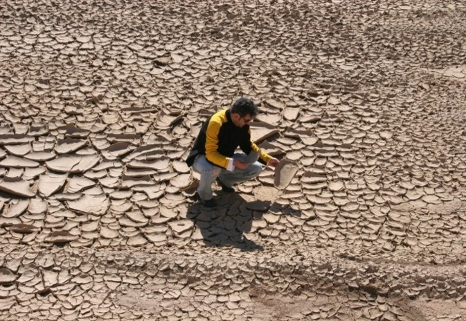
- Drought assessment: Developed a probabilistic drought hazard assessment model based on an analysis of the deviation of the averages of temperature, moisture, and precipitation.
- Air pollution: Assessed spatial distribution of probabilistic events of air pollutants like Carbon Monoxide (CO), Particulate Matter (PM5), Ozone (O3), and Nitrogen Dioxide (NO2).
- Oil spills: Mapped events of historical oil spills, accident based and natural, onshore and offshore, and identified hotspot areas that are likely to experience oil spills. It will help determine highly “sensitive zones” and prepare mitigation plans to avoid severe repercussions on the environment, tourism, aquaculture, and fisheries in the affected areas.
Findings & Recommendations
Basis the detailed hazard assessment, RMSI experts had the following findings & recommendations:
Flash Floods
- Flood modeling for Kuwait indicated that Sabah Al Ahmad City and Fahaheel City are highly susceptible to higher flood water depth during heavy rainfall events
- Recommended development of an early warning system for floods for the State of Kuwait
Sand and Sand Encroachment
- Sand encroachment susceptibility map indicated that very high and high classes of sand encroachment in Kuwait constituted 35% and 22% of the land area, respectively.
- Most of the vital desert installations are located within the zones of very high and high sand encroachment, situated in the main corridor of the sand pathway.
Dust Storm
- Most of the districts located to the western boundary of the State of Kuwait were vulnerable to severe dust deposition during strong to moderate dust storm events.
- Dust storms are more severe during noon to late evening hours and gradually slow down during the night hours. Sometimes the strong dust storm events may last up to 2-3 days in a row.
Drought
- Kuwait is likely to experience drought and hot conditions once in a five-year period.
- Study results will help in taking appropriate adaption measures to deal with the drought and hot conditions hazards.
Air Pollution
- Particulate Matter (PM10 and PM2.5) was frequently exceeding the Kuwait Environment Public Authority standards and the International Standards followed by WHO/China/India.
- Current situation demands immediate attention to pollution mitigation and control.
Oil Spills
- Majority of offshore oil spill events occurred between 100-150 km from the Kuwait City.
- Most of the offshore oil spill events were found in the south-east direction with reference to the Kuwait City.
Strengthening disaster risk management capabilities
The study emphasized using real time forecasting tool and early warning system to minimize any hazard and ensure informed planning measures to save the people, communities, and other assets. This can be beneficial in sand and dust storm as Kuwait is severely impacted by dust storms, especially during the summers.
An Early Warning and Dissemination System (EWDS) will reduce the adverse impacts of frequent sand and dust storms. Through this, oil extraction, distribution, and refining infrastructure can be safeguarded from the sand and dust storm. The citizens can be better prepared by taking cover, sealing windows and doors, vacating streets, ensuring proper parking for their vehicles, and other movable equipment. With the rising frequency of droughts compared to floods, similar interventions can also be planned to avert any severe impact/loss. The detailed hazard assessments shall enable decision-makers to prepare for appropriate action and planning measures to deal with such hazards.
Such a multi-hazard analysis study was essential to comprehend the intensity, severity, and extent of these hazards on Kuwait City and bridge data gaps to arrive at an updated picture of various hazards impacting the country. The multi-hazard analysis recommendations shall aid in comprehensive or sectorial (portfolio) risk assessments, depending on these hazards’ priorities, to estimate the potential losses. These assessments benefit in better planning and disaster mitigation initiatives.