NASA and U.S. Geological Survey estimate that almost 80% of Maldives could be impacted by 2050. In addition, World Economic Forum estimates that Dhaka, Bangladesh, Lagos, Nigeria, Bangkok, and Thailand could have vast tracts of their land submerged by 2100.
Glaciers are melting, rising sea levels, and more intense storms; global warming causes these visible effects by increasing carbon dioxide levels and other greenhouse gases in the atmosphere and ocean.
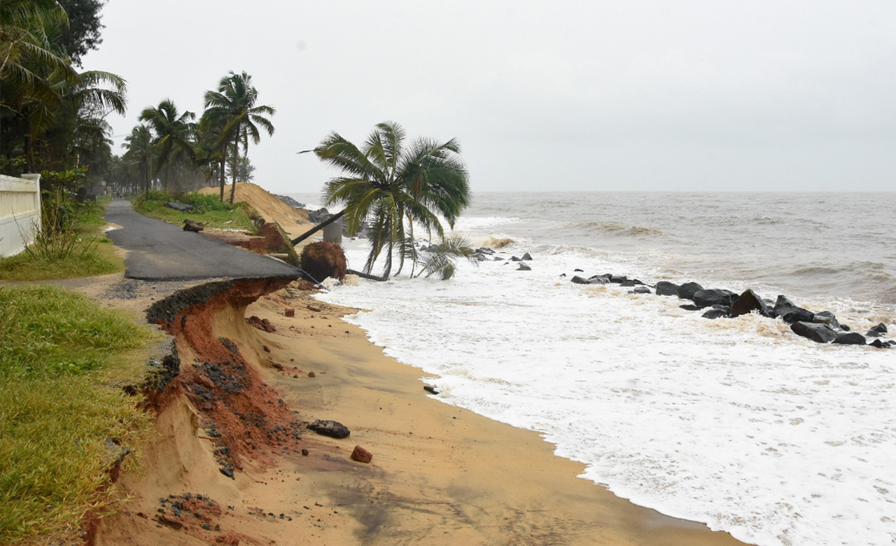
According to the latest Inter-Governmental Panel on Climate Change (IPCC) report, it is expected that the global mean sea level (GMSL) will rise between 0.43 m (0.29–0.59 m, RCP2.6) and 0.84 m (0.61–1.10 m, RCP8.5) by 2100. As a result, it will intensify coastal erosion around the globe, inundating coastal areas with some parts of the coast getting submerged under the ocean.
Why is a slight increase in global temperature causing such big problems for Earth’s ecosystems?
Global sea levels are rising
In 2020, the global mean sea level was 91.3 millimeters (3.6 inches) above the 1993 average, making it the highest annual average in the satellite record (1993-present).
The ocean absorbs and releases more than 80 percent of global warming, storing and releasing heat. It is a significant cause of rising sea levels and the water added to the ocean by melting land-based glaciers and ice sheets. As a result, the global sea level has increased approximately eight inches per the IPCC report since the late 19th century, leading to the destruction of coastal wetlands, salt marshes, and mangrove swamps, as well as flooding and flooding damage to aquatic ecosystems.
Coastal areas are sensitive to sea-level rise, storm frequency, intensity changes, and increased precipitation caused by climate change. Additionally, as atmospheric carbon dioxide (CO2) concentrations rise, more gas is absorbed by the oceans, and the seas become acidic and impact the coastal and marine ecosystems.
Why does sea level matter?
In the past few decades, the ocean has absorbed more than 90% of all heat gained by the planet. This has resulted in various impacts, including coral bleaching, longer and more frequent marine heatwaves, and an energy source for more powerful storms. Globally, 8 of the world’s ten largest cities are near a coast, according to the U.N. Atlas of the Oceans.
Rising seas threaten the infrastructure necessary for local jobs and regional industries in urban settings along coastlines worldwide. Roads, bridges, subways, water supplies, oil and gas wells, power plants, sewage treatment plants, and landfills—the list is endless—are all at risk from sea-level rise.
Key challenges to be addressed
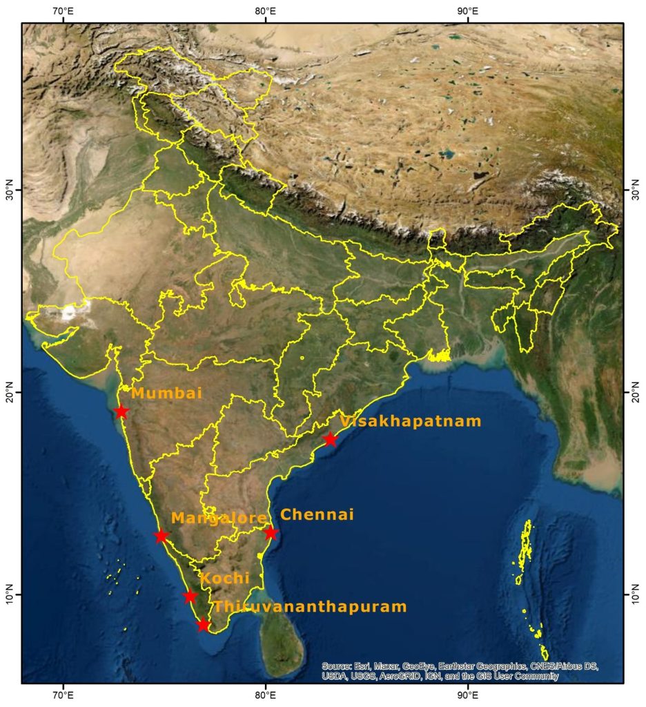
A study conducted by RMSI of the coastal cities in India reveals that by 2050 the mean sea level rise will impact a significant population and infrastructure in and around Mumbai, Kochi, Mangalore, Chennai, Vishakhapatnam, and Thiruvananthpuram.
There is a potential for climate change to worsen problems that coastal areas face today. As per the study conducted by RMSI, most climate change-related issues are currently being addressed in silos. There is a strong need to integrate them as climate change aggravates hydro-meteorological hazards. Secondly, the scope is limited to the state and national authorities without a clear delegation of activities and strategies at the decentralized level. Thirdly, a proper methodology needs to be built for up-scaling the pilot projects.
Based on our study of these cities with limited resources, we believe a detailed analysis of India’s entire coastline is essential. Furthermore, with increasing climate-related impact, it is high time for the government to engage and exchange high-quality topography data with the key stakeholders, professionals, and local communities to address these issues.
How to address this challenge?
RMSI study communicates and highlights the alarming situation of continuous warming in line with current trends of sea-level rise over the coming century and the risk this poses to coastlines worldwide.
The solution to the above problem lies in adopting a scientific approach by mapping coastal changes through the amalgamation of standard and machine learning-based approaches, identifying vulnerable coastal areas, forecasting inundations along the coast, and formulating mitigation & adaptation strategies. Such an approach will help governments around the globe to make more informed decisions and bring forth better planning strategies to develop integrated coastal management plans, having the key focus areas as:
- Identify sea level rise in 2050 and 2100 (will be different at different locations)
- Use of a High-resolution inundation model to identify the areas at risk with higher accuracy
- Create a list of high-risk areas by sector so that respective authorities could work on the mitigation options (e.g., There can be a potential impact on a lot of fisheries along the coast of India)
- Improving the existing infrastructure to be able to handle more flooding
- Upgrading stormwater drainage systems and elevating the sea walls
As global warming continues, we can expect more significant changes along the world’s coasts and a greater risk of disasters in the coming decades.