Climate change has emerged as one of the Earth’s most critical challenges. Increasing sea levels, droughts, floods, extreme weather conditions, and a reduction in wet days are all consequences of global warming. Unfortunately, the growing human population and accompanying economic activities have reduced the resilience of our cities to climate change.
UN and International Organization for Migration estimated that approximately 3 million people are moving to cities weekly. Worldwide 54% of people live in cities, which is estimated to go up to two-thirds of the world’s population in the next fifteen-thirty years. Thus, cities play a critical role in confronting climate change as their exposure to climate and disaster risk increases yearly.
Around half-billion urban dwellers live in coastal regions, making them more vulnerable to flash floods, storm surges, and sea level rise. In the 136 largest coastal cities, 100 million people and $4.7 trillion of assets are exposed to coastal flooding. In addition, 90% of urban growth in developing countries occurs near hazard-prone regions, primarily unplanned and haphazard.[1]
The global expected average annual loss to the built environment associated with tropical cyclones (wind and storm surge), earthquakes, tsunamis, and floods is estimated at US$314 billion as per GAR 2015 report[2]. This is the amount of money required worldwide to shield the future disaster losses associated with these hazards each year.
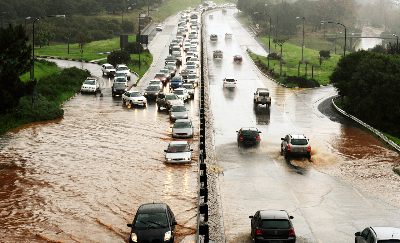
The global increase in intense floods, storms, droughts, and heat waves has a likely and ominous link to climate change. Urban areas are experiencing an additional urban heat island effect. This effect generates more rainfall in the form of short but intense downpours. In turn, the cities are facing an increased risk of flash floods and coastal flooding (due to higher sea levels). Similar impacts can be witnessed as several regions and cities are being hit by disaster events, leading to business interruption and heavy losses to the rebuilt infrastructure facilities, including transportation networks, utility services, and telecommunication networks.
RMSI has analyzed the recent global incidents of intense rainfall resulting in incessant flooding, causing substantial infrastructure losses. The subsequent section highlights a few events where the sudden floods have resulted in huge infrastructure losses.
Flood scenarios for Kwazulu-Natal Province (South Africa), Sydney (Australia), and Telangana (India) have been analyzed by our experts based on RMSI’s proprietary model.
KWAZULU-NATAL (KZN), SOUTH AFRICA
Kwazulu-Natal Province experienced floods in April 2022, resulting in areas in and around Durban being severely hit with major damages to homes and critical infrastructure, including major roads, transportation networks, communication networks, industrial establishments, and electrical systems. This damage significantly hindered recovery and relief efforts.
RMSI modeled flood scenarios for eThekwini Metropolitan Municipality, KZN Province, which has one of the worst affected municipalities. As per the analysis, approximately 331 km of the road network, 283 km of the railway network, two bus stops, and four railway stations were heavily flooded. Around 96,000 people were exposed to this severe localized incident. Other municipalities of Llembe, Ugu, Uthukela, King Cetshwayo, uMgungundlovu, and Umzinyath were also severely impacted.
RMSI’s analysis indicated that the flood forecast and Early Warning System (EWS) could have alerted the authorities at least 72 hours ahead of time. It could have saved more lives and reduced infrastructure damage if accurate information had been promptly transferred.

NEW SOUTH WALES FLOOD, July 2022
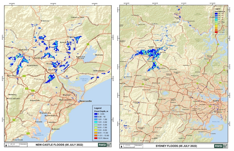
The State of New South Wales, Australia, has experienced three flooding events till July this year. The worst hit was Sydney, with an enormous impact on the infrastructure, such as the road network, telecommunication towers, etc. RMSI analyzed the flood scenarios in and around New Castle and Sydney. As a result, flood maps were created for New Castle (Left) and Sydney (Right) for 5th July 2022, when the flooding was at its peak.
This thematic bulletin (focused on the telecommunications network) is an essential component during any disaster and is necessary for timely rescue management.
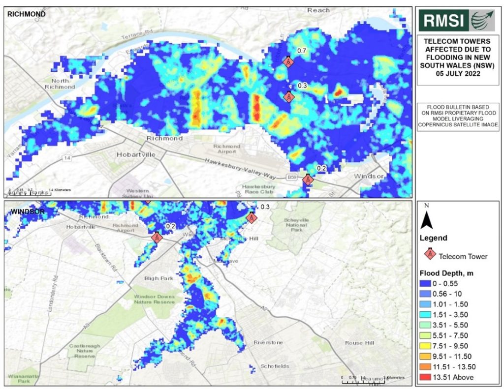
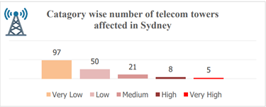
RMSI had collected data for telecom towers across Sydney. Out of 11,700 telecom infrastructure locations, 181 telecom towers were impacted due to the floods. The maximum observed flood depth at any telecom tower was 4.53 m. The below chart depicts the impact of the July 2002 flood event on the telecom towers.
RMSI’s analysis indicates that the repeated flood-like situation in NSW is not the consequence of climate change alone. The local government has taken several steps, such as emergency response, upgrading the evacuation routes, recovery planning, etc. Nevertheless, these measures are insufficient since the State lacks strict regulations for not building in flood-prone and low-lying areas. As a result, construction has continued despite flood risks due to population growth and housing shortages. Lismore is also planning to shift its entire central business district to a flood-prone area.
Furthermore, climate change is projected to bring far worse extreme rainfall events in the long term, which could be more disastrous, causing substantial threats to the cities and infrastructure losses. Consequently, creating future disaster mitigation plans to minimize disaster risk is a prerequisite.
Telangana Floods, July 2022
Intense rainfall over the last week of July 2022 led to floods and water-logging in many parts of Andhra Pradesh and Telangana regions. The submergence of several villages impacting agriculture, major highways, bridges, roads, and railway tracks has led to very high losses across the State. In addition, the incessant rainfall caused heavy runoff, feeding more water in the already swelled-up rivers and reservoirs, leading to rivers overflowing above the danger mark in the State. As a precautionary measure, the disaster management agencies and police imposed restrictions in low-lying areas and closed the Bhadrachalam bridge on the Godavari river. The Godavari has received such a high level of floods after 32 years. As a result, many villages in Dummagudem, Cherla mandals, and colonies in Bhadrachalam were reported to be submerged. RMSI analyzed the rainfall accumulation over the region and depicted it on a map.
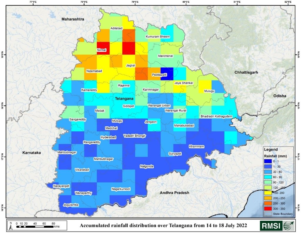
As per the analysis, the districts of Kumuram Bheem, Adilabad, Nirmal, Nizamabad, Jagtial, Peddapalli, and Jaya Shankar Bhupapally experienced heavy rainfall. Maximum accumulated rainfall over the analysis period ranged between 300-350 mm in Adilabad and Nirmal Districts.
Further, RMSI has also modeled the impact based on RMSI’s proprietary flood model and in-house exposure data for Telangana. We have analyzed the extent of different exposure elements (roads, railways, telecom towers, bridges, residential, commercial & industrial buildings, and electric power transmission networks) affected due to rainfall-induced flooding in Telangana.
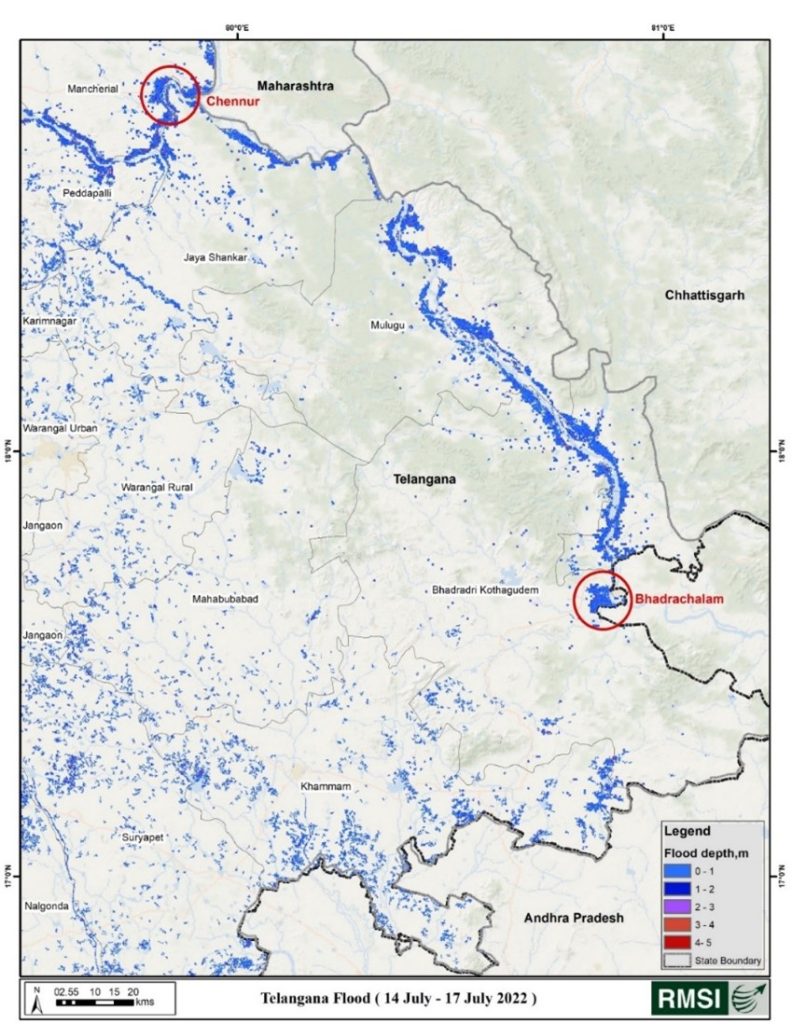
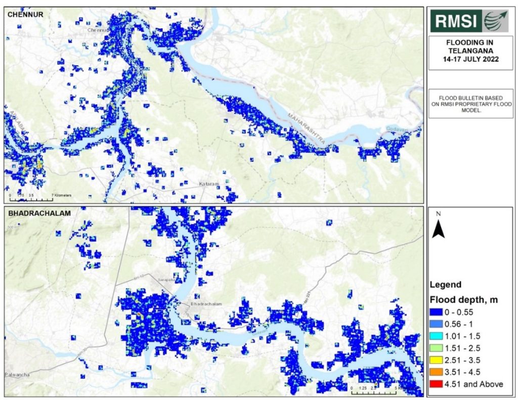
Analysis of the above flood map revealed that floods majorly impacted areas of Bhadrachalam and Chennur. RMSI analyzed these areas in detail and conducted an impact assessment. Our analysis indicated that the Kothagudem district experienced severe flooding with around 35 km of the railway line, 12 km of bridge network, 713 km of transmission line, and 4,060 km of road length. At the same time, the Mancherial district has also experienced a widespread impact on infrastructure due to floods – 1,011 km on road length, 76 km on the transmission line, 47 km on the railway network, and 4 km on the bridge network. Approximately 4.5 m and above flood depth has been observed in some places in Bhadrachalam. In Chennur, the estimated flood depth ranges from 3.5-4.5 m.
Conclusion
All these above studies reveal a scenario where we urgently need to rethink our existing urban planning modes. Urban local bodies or planning agencies should act and build disaster-resilient infrastructure to reduce the risk of losses during a crisis.
While dialogue has been initiated on climate-sensitive urban planning, it is up to local bodies and agencies to implement it on a timed basis.
The above studies also indicate that if strict actions are not taken to reduce greenhouse gases, it will become the most critical challenge for urban cities and planet earth. Presently, climate change issues are being handled in silos. However, collective actions and strategic measures to reduce the carbon footprint and greenhouse gases and strengthen urban services and systems will prove crucial in helping cities battle disaster risk. These strategic measures should be a crucial part of the government’s effort up to the lowest administrative level. Below are some listed efforts for the same.
- A common pattern running across these case studies indicates that extreme events are becoming more and more localized in nature. Private agencies, academicians, and policymakers should come together to develop an understanding of how the impact and risks of climate change can be reduced for sustainable development, especially in developing nations like India, which are vulnerable to climate change. We should look at the best practices and solutions that have worked from past experiences.
- Cities have years-old utility infrastructure; they should strategically make serious efforts to improve the infrastructure, including the age-old stormwater drains and pipelines. But unfortunately, they aren’t designed for the kind of rainfall climate change brings. Hence, there needs to be a detailed analysis and related action on the city’s stormwater system and infrastructure.
- As the global population is growing at an unprecedented rate, it is imperative to include population dynamics in climate change-related education and advocacy. It will help raise awareness of how population growth is worsening the climate change impacts by straining the resources and exposing more people to climate-related risks—especially in low-resource regions.
- Integration of disaster resilience component with land use planning strengthens climate resilience and builds adaptive capacity for people around the globe.
- There is a strong need to integrate the climate change issue with the multi-hazard risk assessment studies as they aggravate the hydro-meteorological hazards.
- Countries are making a global effort (making huge investments) to reduce their carbon footprint by adopting renewable sources (such as solar and wind) and electrifying transportation to reduce emissions from coal, oil, and natural gas. Instead, developed countries like the UK, the US, and Canada should develop solutions more specific to their country’s needs to combat climate change issues.
To address this situation and to ensure that our infrastructure is resilient to changing vagaries of nature, there needs to be an integrated approach from all the relevant stakeholders of the economy.
From installing a robust early warning system to quick response, the district administration should closely coordinate and monitor mitigation activities. Furthermore, the herculean task of overhauling the civic infrastructure should be taken in a staggered manner so that an immediate drain on the public exchequer is not witnessed.
[1] https://www.worldbank.org/en/topic/urbandevelopment/overview