Over the past few decades, innovations have been focused on enhancing and optimizing the user experience, be it the digitization of analog services or business models – digital banking, payment wallets, online shopping, social networking, and open source mapping. As we look ahead to the next decade, a new wave of tech innovation is emerging – autonomous vehicles, 5G, smart cities and even the metaverse – which will reshape how we connect, collaborate, and consume. The environment has changed dramatically, from how new cities are imagined to how micro-towns are planned. There is exponential growth in location-based economies, from e-commerce to food delivery and mobility. Micro location and hyperlocal data are crucial for this new paradigm’s success. The new-age open-source maps like OpenStreetMap, Mapillary, and Ushr will allow users to edit their location-based data on maps in order to personalize the space.
OpenStreetMap (OSM) is one such well-recognized platform in the mapping community worldwide. It’s a freely available and openly editable map of the world founded in 2004 by Steve Coast. It is the world’s largest volunteer Geographic Information Project and is characterized by its map and the active community of the millions of mappers who produce it.
OpenStreetMap is a valuable source of geospatial data & considered Wikipedia for maps. Currently, there are more than 8 million registered users & over 4 million map changes/day. Community is what makes OSM unique, and the most exciting thing is that data can be created or edited by the users and made live in a matter of minutes, making it available instantly.
Moreover, users have access to add any attributes like tourist attractions, schools, shops, lakes & even tiny objects like benches, street lamps, post boxes, etc.
At RMSI, our mission is to work towards bringing the digital and physical worlds together through technology-driven solutions. In that direction, RMSI, while working on a national mapping project in India, experienced missing and obsolete Point of Interest (POI) data that needed attention.
In the era of volunteer geographic information (VGI), such as OpenStreetMap (OSM), user-generated content has become a valuable resource for capturing all aspects of our environment and lives. OSM data is widely used, and the quality of its Point-of-interest (POI) component needs to be evaluated more carefully.
In this blog, we will share our experience and knowledge of implementing, updating/modifying the missing POI data on the OSM Platform.
Map Intelligence with OpenStreetMap (OSM):
OSM is a web-based public platform that collects data describing the position of roads, rivers, towns, points of interest, etc., used to create maps.
RMSI mapping experts recently witnessed loads of missing POI data while working on a national mapping project in India.
Hence, we started an initiative towards adding missing POIs in OSM data across the country (India) with the help of the latest sources available.
While on this initiative, our mapping experts noticed that many major POIs didn’t even exist on most maps. Therefore, we saw the need to add and modify the existing outdated POI attributes/tags as per the latest available Open resources.
Data is the key to solving most problems, but first, let’s define POI.
Point of Interest ( POI ) in OSM
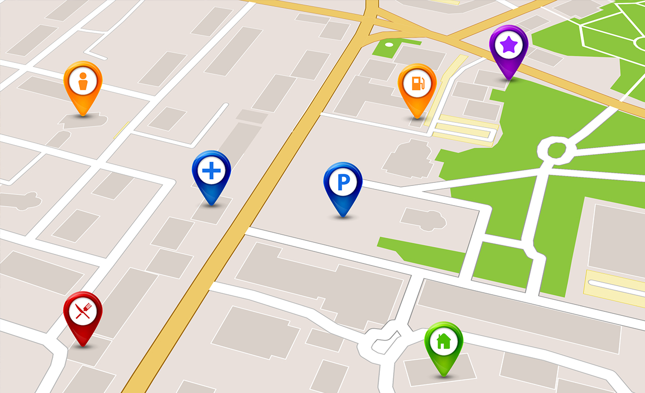
A point of interest is a specific place or location on a map that someone might find interesting or useful. A POI has multiple attributes that provide valuable information about a place/business. It can be a restaurant, a hotel, a tourist attraction, or places like ATMs, gas stations, schools, or parks. A point of interest can be temporary, such as an event, or it can be permanent such as a building or even a city.
Point of Interest (POI) is usually defined by their geographical coordinates along with additional attributes such as name, category, address, opening hours, and contact details. This information is important because it feeds many location-based applications, such as digital maps and navigation systems. By connecting to this data, we can add a deep level of location information to our website or app.
In the era of ‘at your door’ services, point-of-interest data becomes increasingly important. A precise location reference would make delivering these services more accessible.
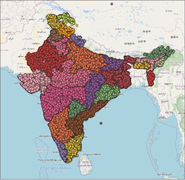
OpenStreetMap has millions of Points of Interest & India has the most extensive POI data in the World.
What are the major challenges in India’s existing Point of Interest ( POI ) Data?
- Inconsistency in existing POI data that requires upgradation
- Important POIs within the country, such as Public Service Facilities, Transportation Terminals, and Educational Facilities, need to be upgraded as per the recent ground truth to locate accurately.
- Lack of awareness of free editable mapping platforms like Openstreetmaps in remote parts of the country.
- Lack of Street Level Imagery coverage like Mapillary across the country except few major cities to validate the POI existence.
- Missing detailed address of the POI in a majority of home websites of POIs
- Dynamic real-time changes in the location and existence of the POIs per the available location coordinates.
To resolve the key challenges in the existing POI data, RMSI is working on adding major POI data across the nation.
Challenges observed in the OpenStreetMap with respect to POI:
- Spam contribution by users
- New community users lack awareness of how to add POIs except in major cities.
- The vandalization of POI data due to lack of tool knowledge by new mappers
- Lack of ground-level resources like mapillary support limits users to confined regions
- Unavailability of the source of information to get enough details about a location & attributes of the POI
Key Benefits of POIs
- Accurate and complete POI data in maps will ensure efficient navigation.
- One can use POI as their destination when traveling to an unfamiliar route.
- Navigation system becomes easier to provide routes.
- It helps to generate statistics of data.
- It is a combination of spatial and non-spatial data that helps to capture pictures and collation of attributes of related assets like name and address.
How RMSI is Contributing/ Enhancing Point of Interest (POI) Data on OSM in India?
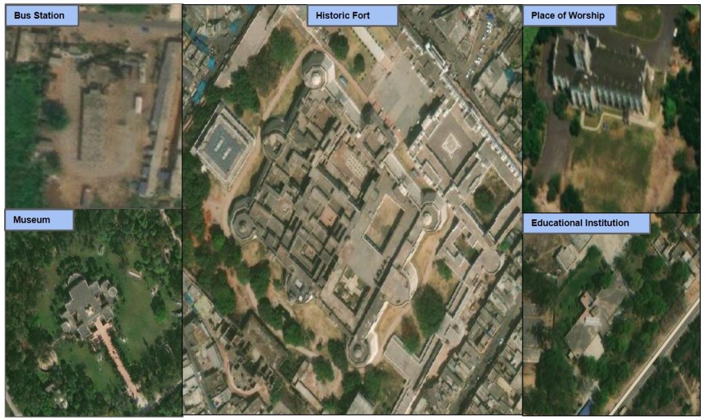
RMSI has enhanced the Point of Interest data in major cities and towns of India. RMSI OSM team also identified and modified Major POI’s In India , upgraded outdated tags. RMSI team identified major POI’s such as Tourism Spots, Public Service Facilities, Transportation Terminals, Educational Facilities, Cultural and Historic Facilities, Religious Facilities etc. which are missing and also need upgradation of tags/attributes for existing POI’s.
Point of Interest ( POI ) Workflow
RMSI improved the workflow of POI data additions with various resources like the PMGSY dataset and OGD data. Secondary resources such as Mapillary were used in reference to the latest and updated imagery. We also used Aerial Imagery, OSM Country wiki, and other website address information to validate the POI.
Workflow Methodology
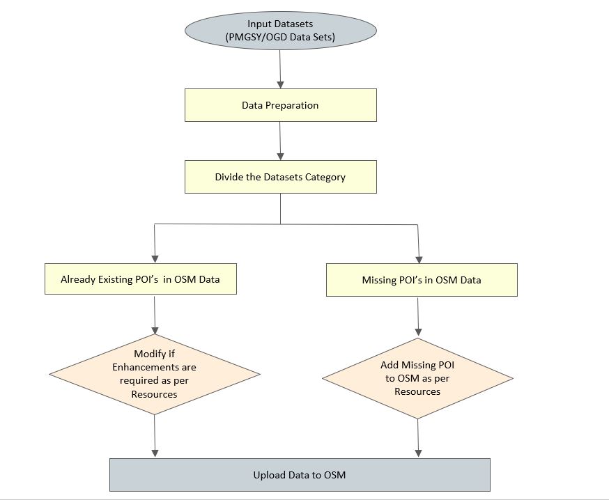
Finding POI data
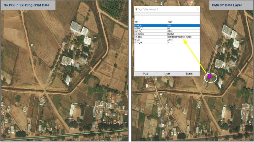
Identifying POI data is of vast importance, and we have multiple ways to acquire and upload the POI data in OSM. For example, in India, we have a huge open data set on various facilities in the form of a PMGSY dataset where multiple categories of POIs across India are listed. Another way to identify the POIs is through web searches and ground surveys through customized applications.
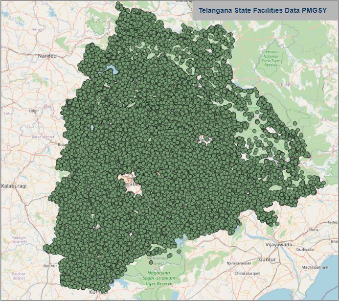
In the PMGSY dataset, we have multiple POI categories listed with massive coverage of around 7.8 Lakh POIs across India.
Below is the overall category-wise list of the various facilities’ data released under PMGSY
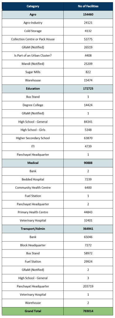
In the above category list, if you observe, there are some facilities where the categories are incorrectly added.
Example: A bus stand facility is added to the Education category, and banks, fuel stations, and panchayat headquarters have been incorrectly added to the Medical category.
For all such cases, we have to manually check and validate the category of the facility per its characteristics and update the data accordingly.
PMGSY facilities availability across India
Using Mapillary to enhance the data
Mapillary is one of the prominent street-level imagery providers across the globe. Mapillary is the platform that makes street-level images and maps data available to scale and enhance mapping. While working with open datasets like PMGSY, we take the help of Mapillary to validate the existence of POI through street-level imagery wherever mapillary exists.
Mapillary as a Resource Example :
Here is one example where Mapillary is used as a resource to validate the school, which is available in the PMGSY data set but missing in OSM Map Data.
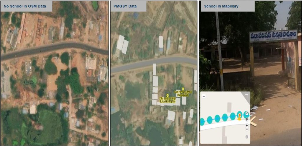
Hence as per the above example, we have validated the existence of the exact location of the school building and added the school POI to OSM Maps.
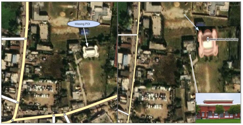
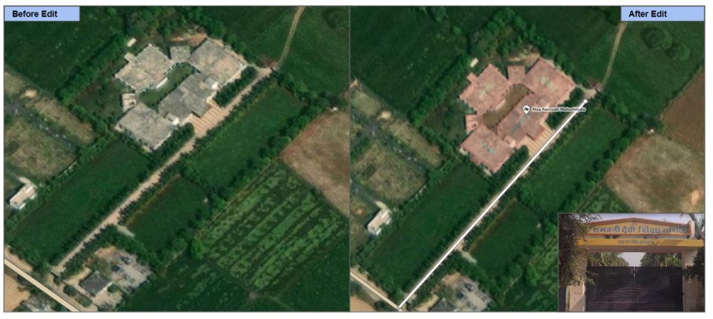
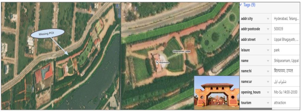
Example: There are multiple cases where the POI data is missing or needs an upgrade in various edits like attributes, polygon alignment, etc.
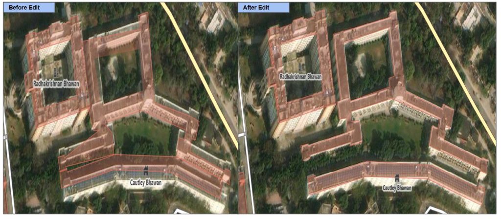
In the example below, An historical fort is missing in OSM.
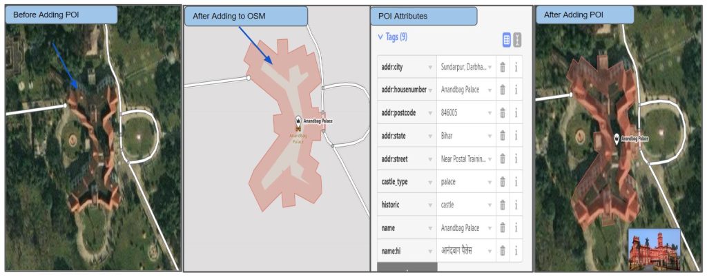
RMSI’s Solution for POI Additions / Enhancement
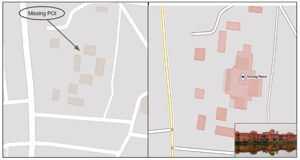
1. Missing Major POI additions: In India’s OSM data, the most important POI was missing in OpenStreetMap data.
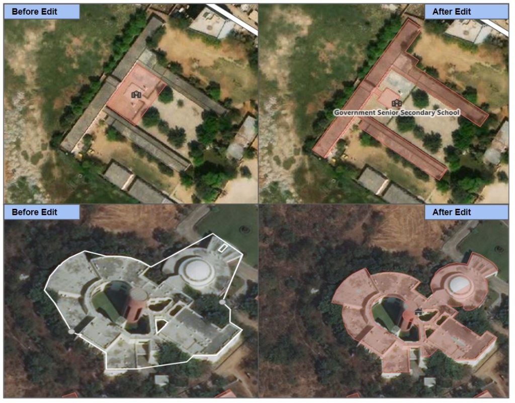
2. Existing POI Data Upgradation: Attributes
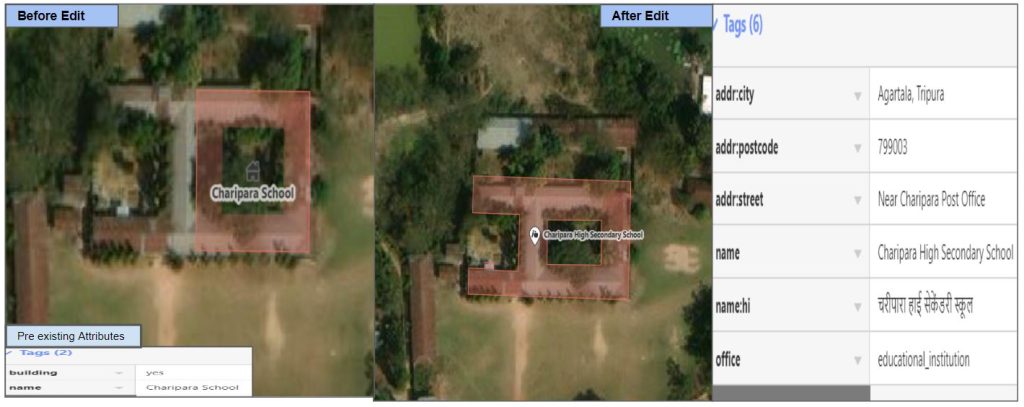
3. Alignment of Polygon as per Ground Truth:
RMSI’s Role in Data Maintenance and Upgradation
Since OSM is an open-source platform, there are chances of unintentional data vandalism by any new users; hence, there is a need to monitor the data and make the necessary changes when required. Therefore, RMSI frequently uses various tools to monitor the data and make the required corrections.
We use error-detecting tools to examine the OSM POI data for potential errors and inaccurately mapped places. We ignore false positive cases to maintain the real-time data as per ground truth.
Since the quality and accuracy of POI placement/position plays a major role in POI, we check for data vandalism and ensure data is consistent and updated in terms of accuracy. Apart from these, we also look for POI Building Geometry, POI attributes, etc.
Quality Assurance:
As the OSM is a live database, it is crucial to ensure the uploaded data is accurate with high precision. To achieve this high precision data, the RMSI team performs Quality checks on a minute level by using various tools like JOSM, Osmose, OSM Inspector, Openhoursvalidator, and various other customized overpass queries to ensure data is highly accurate.
Data Maintenance:
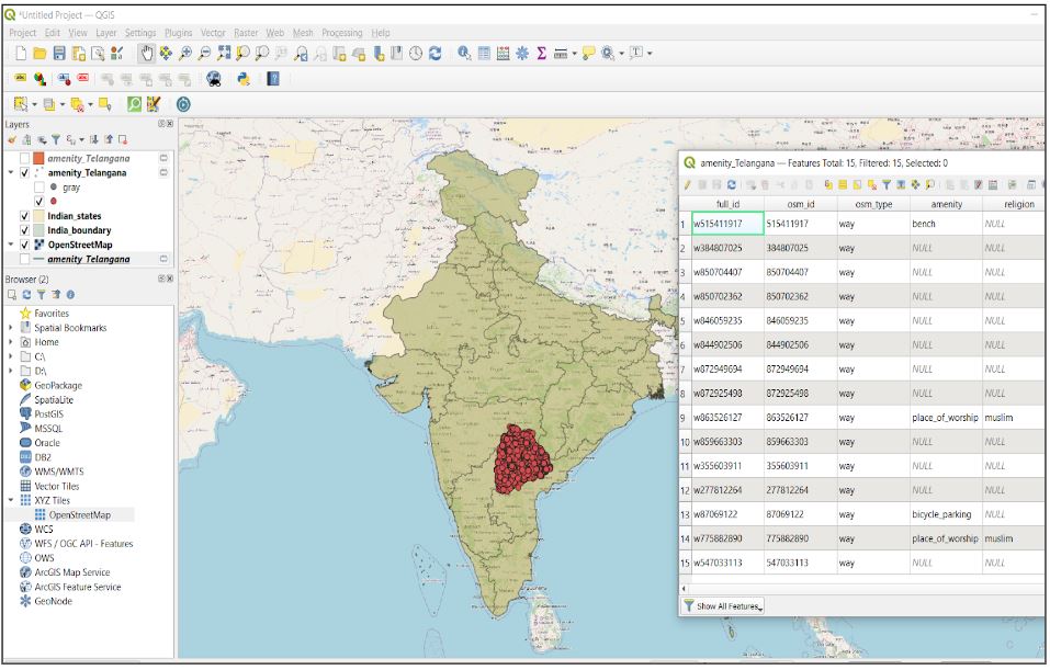
Due to OSM’s open-source nature, data is continually being modified and updated in real time. Hence, maintenance plays a prominent role in safeguarding the data. We use the QGIS tool, and various overpass queries to constantly monitor the data and address all the changes performed on these POIs. The maintenance team simultaneously validates the changes with all the available resources and makes necessary changes wherever required.
Acknowledgment
RMSI is currently working to support expanded Information Management capacity within India. We aim to provide accessible data of accurate Road Network Information useful for those using OpenStreetMap.
RMSI aims to collaborate with the OpenStreetMap community to create high-priority road data, major missing POIs validated by trained mappers and local OSM communities in India.
Our team constantly works to add & modify accurate major POI data across the country. But, core to the above goal is also ensuring that Major data is easily accessible to everyone using OpenStreetMap (OSM).
If you are interested in improving the major POI network, please get in touch with us at osm@rmsi.com.
Happy Mapping & Happy New Year 2023!