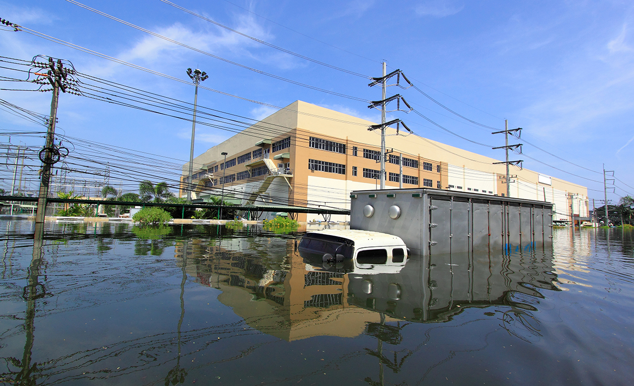
I recently visited Bengaluru, India, known for its high-tech innovation centers and thriving urban development. However, I was taken aback when I learnt that the city used to have 1000 lakes at one time, but now only 80 of them remain! (source: https://mgiep.unesco.org/article/the-bangalore-lake-diaries)
This drastic decrease is due to the city’s rapid expansion over the last four decades, which has caused an impending water scarcity crisis, as reported by NITI Aayog (http://social.niti.gov.in/uploads/sample/water_index_report2.pdf ). Apart from this, the city has been grappling with severe floods since 2000, caused by the reclamation of natural lakes and ponds and the proliferation of impermeable surfaces. These changes have disrupted the natural slopes of the city, leading to increased flooding. The BBMP report on Lake Development Authority also confirms this fact.
What’s happening in Bengaluru is not unique only to this city. Rapidly increasing urban sprawls in Asian cities are increasingly contributing to climate change, posing a significant risk to communities in these cities. It has caused substantial changes in the area’s topography pattern and land cover. However, this growth has also negatively affected the physical environment, including loss of agricultural land, depletion of surface and groundwater, changes in geomorphic features, flooding, and landslides. As the population grows alarmingly, it is crucial to adopt proper urban planning to achieve a sustainable environmental balance.
These cities have tremendous potential to help in climate adaptation, especially through transit-oriented development (TOD) strategies. In this blog, we will discuss the importance of TOD, the need to address shortsighted urban development, and measures to be taken in accordance with proper planning for the urban expansion of cities in the future.
What is Transit-Oriented Development?
Transit Oriented Development (TOD) is an urban planning and design concept that prioritizes development around public transit infrastructure, such as train or bus stations. Such strategies can contribute significantly to climate adaptation in managing and preventing disaster risks in these cities. It includes building resilience to disaster risks by supporting high-density housing and activities in lower-risk zones, reducing traffic congestion, improving air quality, increasing access to jobs and services, and promoting physical activity.
Why is the TOD strategy ideal for Asian cities?
According to the data from the United Nations, 7 out of the top 10 most densely populated cities in the world in 2021 are Asian cities. The combination of high population density, robust public transportation systems, rapid urbanization, and land scarcity make Asian cities ideal for implementing TOD strategies. Moreover, the cities could leverage this combination with TOD to co-benefit other major urban improvements, like controlling GHG emissions and the urban heat island effect.
Due to the high densities of cities in Asia, TOD can drive up the land value, which could capture additional finance improvements. For example, between 1980 and 2005, the implementation of land value capture in Hong Kong SAR resulted in revenue of HK$140 billion. It made land available for the construction of 600,000 affordable public housing units. (https://openknowledge.worldbank.org/handle/10986/26405)
Where, When, and How to Implement TOD: the 3V Framework by World Bank
To determine the suitability of a neighborhood for Transit Oriented Development (TOD) and to identify the appropriate type of development for each area, a recent World Bank study suggests evaluating the “three values” (3V) of the neighborhood: transit connectivity, quality of the urban environment, and market potential. (https://openknowledge.worldbank.org/handle/10986/26405)
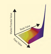
These three values are quantified using indexes.
- Node value is quantified using an index based on passenger traffic volume, intermodality, and centrality within the network.
- The place value index is based on the urban quality of a place and its attractiveness in terms of amenities, schools, health care, the type of urban development, etc.
- The market potential value is quantified based on an index that considers market analysis and potential changes in zoning, such as increasing floor area ratios (FARs) and market vibrancy.
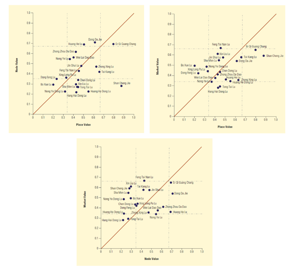
To make well-informed decisions regarding Transit-Oriented Development (TOD), research institutions and governments have created different methodologies given in the 3V framework. These methodologies can aid in identifying station areas that are suitable for TOD, assessing the level of density that the area around a station can accommodate, and determining the appropriate development mix that strikes a balance between housing, job opportunities, and other amenities.
Successful cases of TOD strategy for building climate adaptation and disaster resilience
The potential of Transit Oriented Development (TOD) to contribute towards climate adaptation has been largely overlooked and underutilized.
Implemented strategically, TOD can potentially increase a city’s resilience to natural disasters compared to other forms of development. It is due to the fact that TOD encourages the clustering of activities and residences within a city, allowing for the identification of low-risk zones to accommodate high-density development. This enables cities to systematically address risks in those areas and ensure that high concentrations of people occur in zones with high levels of network redundancy. Consequently, the government can transform such areas into well-connected emergency refuge zones.
Let us look at some successful cases of applying TOD for building climate adaptation and resilience to natural hazards.
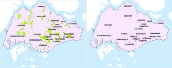
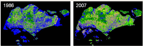
The Concept Plan of Singapore for reducing flood-prone areas and increasing green cover
Singapore adopted a long-term integrated land use and transportation plan for 40 to 50 years, which resulted in significant changes. The Concept Plan determined locations for major infrastructure projects like the Mass Rapid Transit (MRT) Network, future housing, and commercial and industrial clusters. Because of this plan, the green cover in the city increased by 1/3 between 1986 and 2007 (NParks, 2016). It also reduced its flood-prone area from 3,178 ha in the 1970s to only 34 ha in 2013 (IWRM, 2014).
The Role of Transit in Improving emergency evacuation in New York
The New York metropolitan area faces significant danger from hurricanes. To prepare for this, New York City Transit (NYCT) has created comprehensive evacuation strategies that consider varying intensities of hurricanes and the geographic distribution of the population in storm surge-prone areas.
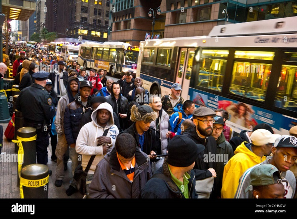
These strategies rely on population estimates provided by the NYC Office of Emergency Management. In addition, there is close coordination between transit agencies and the Chicago Office of Emergency Management and Communications for emergency evacuation management.
Promoting Green Growth in Copenhagen through Transit-Oriented Development – The Finger Plan
The implementation of TOD (Transit-Oriented Development) has resulted in the emergence of highly concentrated, pedestrian-friendly city centers that are well-connected by public transportation systems based on the rail in Copenhagen.
Between 1993 and 2010, Copenhagen’s metropolitan and regional economy experienced a growth of 30%, as determined by its gross value added per capita. During this time, transport-related carbon emissions also decreased by 9%.
Copenhagen has set comprehensive objectives for cycling that encompass both the quantity and quality of cyclists, considering factors such as safety, security, travel duration, and comfort. As a result, the city has successfully established nearly 370 kilometers of exclusive cycling lanes. It has seamlessly integrated cycling into its public transportation system, alongside implementing diverse measures such as information campaigns, training programs, and safety initiatives.
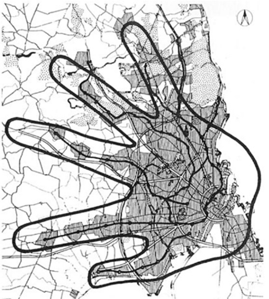
Transit Routes in Copenhagen – The Five-Finger Plan
Based on TOD strategies, the Five Finger Plan has successfully promoted green growth in the city.
Five Finger Plan
The Five Finger Plan, a development plan from 1947 created in collaboration with urban planners Steen Eiler Rasmussen and Christian Erhardt “Peter” Bredsdorff, focused on metropolitan train lines and green spaces between them. The plan designated five corridors for urban development, all of which were situated along railway lines to provide convenient transportation to Copenhagen’s central business district.
Toyama, Japan – a model city for the District Energy Cities Initiative at the UN Climate Summit
Increasing CO2 emissions from automobiles led Toyama to change its urban development policies from expansive to compact. The urban blueprint identified railway and tram routes within the city and specific bus lines that serve as public transportation corridors, linking the city center with suburban centers and essential facilities such as the airport, hospitals, and university.
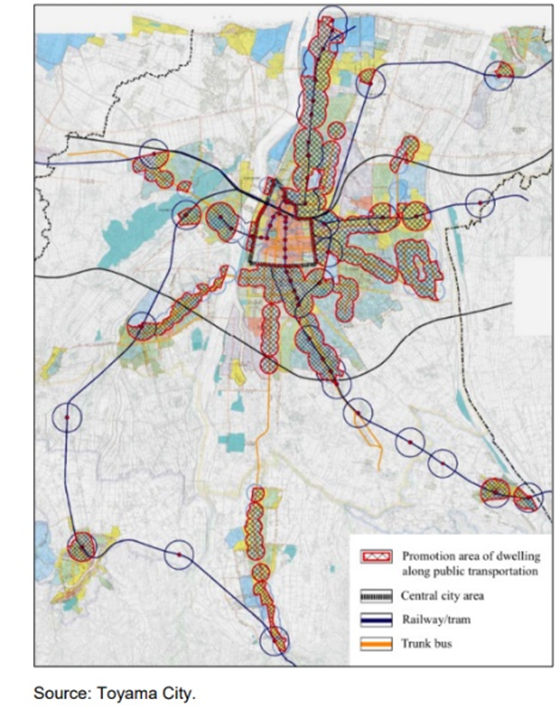
The city’s administration implemented a 7.6 km Light Rail Transit (LRT), which transformed the conventional suburban railway into a contemporary LRT network and initiated a loop-line operation in the city center that connects the city tram with LRT. The model has been successful in controlling the CO2 emissions from automobiles.
What can we learn from successful cases?
The approach of Transit Oriented Development aims to identify and rectify any possible discrepancies between the values of nodes, places, and market potential, as we have seen in the examples above. It is done to create fresh economic opportunities, such as enhancing the urban environment around a significant transit hub or upgrading public transit services to an expanding area. It also builds climate and disaster-resilient cities, which is the need of the hour, particularly in Asia.
Overall, integrating TOD principles into urban planning and development has enormous potential in Asia. It can also help achieve the Sendai Framework (SFDRR) goals by creating safer, more resilient, and sustainable communities better equipped to withstand and recover from disasters. RMSI provides services closely aligned with the Sendai Framework, focusing on reducing causalities and people affected by disasters and improving infrastructure resilience to make the world more resilient to climate change. We are now looking forward to tapping the potential of Transit Oriented Development for building climate and disaster-resilient Asian cities in the near future.
In conclusion, transit-oriented development strategies have the potential to contribute significantly to climate adaptation in rapidly developing Asian cities like Bengaluru. The cities can contain their populations and promote environmentally friendly urban developments while minimizing disaster risks.